
Sør-Varanger Municipality facts for kids
Quick facts for kids
Sør-Varanger kommune
|
|||||
|---|---|---|---|---|---|
|
Municipality
|
|||||
 |
|||||
|
|||||

Sør-Varanger within Finnmark
|
|||||
| Country | Norway | ||||
| County | Finnmark | ||||
| District | Øst-Finnmark | ||||
| Established | 1 Jul 1858 | ||||
| Administrative centre | Kirkenes | ||||
| Area | |||||
| • Total | 3,971.42 km2 (1,533.37 sq mi) | ||||
| • Land | 3,458.85 km2 (1,335.47 sq mi) | ||||
| • Water | 512.57 km2 (197.90 sq mi) 12.9% | ||||
| Area rank | #6 in Norway | ||||
| Population
(2024)
|
|||||
| • Total | 10,063 | ||||
| • Rank | #112 in Norway | ||||
| • Density | 2.5/km2 (6/sq mi) | ||||
| • Change (10 years) | -0.3% | ||||
| Demonym(s) | Varangværing | ||||
| Time zone | UTC+01:00 (CET) | ||||
| • Summer (DST) | UTC+02:00 (CEST) | ||||
| ISO 3166 code | NO-5605 | ||||
| Official language form | Bokmål | ||||
| Preceded by | Vadsø Municipality | ||||
|
|
|||||


Sør-Varanger is a municipality in Finnmark county, Norway. It is also known by its names in other languages, like Máttá-Várjjat in Sami. The main town and administrative center is Kirkenes.
Sør-Varanger is special because it is the only Norwegian municipality that shares a land border with Russia. The main border crossing is at Storskog. Other villages in the municipality include Bjørnevatn, Bugøynes, Neiden, and Sandnes.
This municipality is very large, covering about 3,971 square kilometers. It is the 6th largest municipality in Norway by area. About 10,063 people live here, making it the 112th most populated municipality in Norway.
Contents
About the Name
The name Sør-Varanger comes from the large Varangerfjorden (Varanger Fjord). This fjord is located along the northern coast of the municipality. The word "Varanger" might come from an old Norse word meaning "fishing village" and "bay" or "small fjord."
The name was first spelled Sørvaranger or Sydvaranger. In 1917, the spelling was officially changed to Sør-Varanger.
A Look at History
Early Times
People have lived in the Sør-Varanger area for a very long time. Ancient stone structures called labyrinths found at Holmengrå might have been used for religious ceremonies.
The first people to live here were the Skolt Sami. This group of Sami people moved between the coast and inland areas. They lived in parts of what are now Norway, Finland, and Russia. In the 1500s, they became Russian Orthodox Christians. The old chapel of Saint George at Neiden, built in 1565, shows this eastern influence.
Border Changes
Sør-Varanger became part of Norway in 1826. Before that, it was a shared area between Russia and Norway. This area had a small group of Eastern Sami people who were under Russian rule. When the borders were set in 1826, it caused problems for the Sami who used to move freely.
The Norwegian government encouraged Norwegian settlers to move to the area. They built Lutheran churches to balance the Orthodox traditions. One famous church is the King Oscar II Chapel. It was built in 1869 right near the Russian border to mark it.

In the 1800s, Finnish settlers, called Kven, also came to the valleys. Later, many Norwegians arrived after 1906 because of iron mining near Kirkenes. The area's border changed again in 1944. The Petsamo area, which bordered Sør-Varanger, was given to Finland after the Treaty of Tartu. This meant Norway no longer bordered Russia directly. But in 1944, Finland gave Petsamo back to the Soviet Union, and Sør-Varanger once again bordered Russia.
Mining and War
In 1906, a company called Sydvaranger started the Bjørnevatn Mine near Bjørnevatn. Four years later, a railway was built to connect the mine to the port in Kirkenes. This railway, called the Kirkenes–Bjørnevatn Line, was once the world's northernmost. The mine closed in 1996 but reopened in 2009.
During World War II, in October 1944, Soviet forces pushed Nazi-Germany's forces out of the municipality. Many people in Kirkenes hid in mining tunnels during heavy bombing.
Becoming a Municipality
Sør-Varanger officially became a municipality on July 1, 1858. It was created when the larger Vadsø Municipality was divided. The part south of the Varangerfjorden became the new Sør-Varanger municipality. Its borders have stayed the same since then.
On January 1, 2020, Sør-Varanger became part of the new Troms og Finnmark county. Before that, it was part of the old Finnmark county. Then, on January 1, 2024, the Troms og Finnmark county was divided again. Sør-Varanger once more became part of Finnmark county.
The Coat of Arms
The coat of arms for Sør-Varanger was approved on April 16, 1982. It has a diagonal line shaped like flames, dividing the shield into yellow and red parts.
The three flames on the shield are very symbolic. They represent three important things for the municipality:
- The three main ways people earn a living: agriculture (farming), mining, and fishing.
- The three main rivers that form borders with Norway, Russia, and Finland: the Neiden, Pasvikelva, and Jakobselva.
- The three main cultures in the municipality: Norwegians, Finns, and Sami.
The artist who designed the arms was Sissel Sildnes.
Geography and Nature


Sør-Varanger is a huge area of about 3,700 square kilometers. It is located between Finland and Russia. Most of the land is covered by low-lying forests of pine and birch trees. The areas facing the Barents Sea are more barren. The highest point in the municipality is Báhttervárri mountain, which is 497.1 meters tall.
The Varangerfjorden runs along the northern part of the municipality. The Bøkfjorden cuts into the municipality from north to south. The large island of Skogerøya is on the west side of the Bøkfjorden. Skogerøytoppen is the tallest mountain on Skogerøya. The Bøkfjord Lighthouse is at the mouth of the Bøkfjorden.
The main town, Kirkenes, is on a peninsula in the Bøkfjorden. Other places to live include Bugøynes, Neiden, and small villages along the Pasvikelva river. The local airport, Kirkenes Airport, Høybuktmoen, is also a military base. The Garrison of Sør-Varanger (GSV) is located there.

The plants in this area are similar to those found in Russian and Siberian taiga forests. You can even find a few hundred Russian spruce trees here. Bears also live in the upper valley, especially in the Øvre Pasvik National Park, Øvre Pasvik Landscape Protection Area, and Pasvik Nature Reserve.
Important lakes in the area include Ellenvatnet, Gardsjøen, and Klistervatnet. Korsfjorden is one of the fjords.
Climate
Sør-Varanger has a boreal climate, also known as subarctic. This means it has long, cold winters. Summers are short, but they can sometimes be warm.
| Climate data for Kirkenes Airport 1991–2020 (89 m, extremes 1957–2020) | |||||||||||||
|---|---|---|---|---|---|---|---|---|---|---|---|---|---|
| Month | Jan | Feb | Mar | Apr | May | Jun | Jul | Aug | Sep | Oct | Nov | Dec | Year |
| Record high °C (°F) | 5.3 (41.5) |
7.3 (45.1) |
6.1 (43.0) |
14.4 (57.9) |
28.8 (83.8) |
31.6 (88.9) |
32.7 (90.9) |
30.7 (87.3) |
22.2 (72.0) |
13.6 (56.5) |
8.8 (47.8) |
7 (45) |
32.7 (90.9) |
| Mean daily maximum °C (°F) | −6.8 (19.8) |
−6.8 (19.8) |
−2.9 (26.8) |
1.7 (35.1) |
7.2 (45.0) |
12.2 (54.0) |
16.2 (61.2) |
14.7 (58.5) |
10.1 (50.2) |
3 (37) |
−2.2 (28.0) |
−4.3 (24.3) |
3.5 (38.3) |
| Daily mean °C (°F) | −10.1 (13.8) |
−9.9 (14.2) |
−5.6 (21.9) |
−0.8 (30.6) |
4.3 (39.7) |
8.7 (47.7) |
12.4 (54.3) |
11.3 (52.3) |
7.3 (45.1) |
1.2 (34.2) |
−4.4 (24.1) |
−7.3 (18.9) |
0.6 (33.1) |
| Mean daily minimum °C (°F) | −13.2 (8.2) |
−13 (9) |
−9.1 (15.6) |
−4.2 (24.4) |
1.2 (34.2) |
5.6 (42.1) |
9.2 (48.6) |
8.3 (46.9) |
4.8 (40.6) |
−0.8 (30.6) |
−6.9 (19.6) |
−10.2 (13.6) |
−2.4 (27.8) |
| Record low °C (°F) | −41.8 (−43.2) |
−38.9 (−38.0) |
−29.8 (−21.6) |
−20.9 (−5.6) |
−13.6 (7.5) |
−2.5 (27.5) |
2.4 (36.3) |
−1.5 (29.3) |
−5.9 (21.4) |
−21.7 (−7.1) |
−27.5 (−17.5) |
−34 (−29) |
−41.8 (−43.2) |
| Average precipitation mm (inches) | 31.3 (1.23) |
30 (1.2) |
28.7 (1.13) |
26.9 (1.06) |
26.8 (1.06) |
49.2 (1.94) |
56.2 (2.21) |
55.4 (2.18) |
37.9 (1.49) |
43.7 (1.72) |
36.8 (1.45) |
32.5 (1.28) |
458.8 (18.06) |
| Average precipitation days (≥ 1.0 mm) | 9 | 7 | 6 | 6 | 6 | 7 | 9.0 | 9 | 7 | 10 | 9 | 8 | 93 |
| Source 1: yr.no/statistics Kirkenes Airport | |||||||||||||
| Source 2: Météo Climat | |||||||||||||
| Climate data for Kirkenes Airport, Høybuktmoen 1961-90 | |||||||||||||
|---|---|---|---|---|---|---|---|---|---|---|---|---|---|
| Month | Jan | Feb | Mar | Apr | May | Jun | Jul | Aug | Sep | Oct | Nov | Dec | Year |
| Mean daily maximum °C (°F) | −8.2 (17.2) |
−7.8 (18.0) |
−3.8 (25.2) |
0.6 (33.1) |
5.7 (42.3) |
12.5 (54.5) |
16.1 (61.0) |
13.9 (57.0) |
8.8 (47.8) |
2.4 (36.3) |
−2.8 (27.0) |
−5.9 (21.4) |
2.6 (36.7) |
| Daily mean °C (°F) | −11.8 (10.8) |
−11.3 (11.7) |
−7.4 (18.7) |
−2.4 (27.7) |
3.0 (37.4) |
8.5 (47.3) |
12.1 (53.8) |
10.5 (50.9) |
6.2 (43.2) |
0.4 (32.7) |
−5.5 (22.1) |
−9.7 (14.5) |
−0.6 (30.9) |
| Mean daily minimum °C (°F) | −16.2 (2.8) |
−15.1 (4.8) |
−10.8 (12.6) |
−5.7 (21.7) |
0.0 (32.0) |
5.2 (41.4) |
8.7 (47.7) |
7.5 (45.5) |
3.6 (38.5) |
−1.9 (28.6) |
−8.7 (16.3) |
−13.4 (7.9) |
−3.9 (25.0) |
| Average precipitation mm (inches) | 32 (1.3) |
23 (0.9) |
21 (0.8) |
20 (0.8) |
23 (0.9) |
41 (1.6) |
60 (2.4) |
62 (2.4) |
47 (1.9) |
35 (1.4) |
33 (1.3) |
33 (1.3) |
430 (16.9) |
| Average precipitation days (≥ 1 mm) | 8.5 | 6.5 | 6.0 | 6.2 | 6.0 | 8.2 | 8.9 | 10.5 | 9.8 | 9.5 | 8.6 | 9.0 | 97.7 |
| Source: Norwegian Meteorological Institute | |||||||||||||
Economy and Work
The service sector is very important for jobs in Kirkenes. Kimek, a company that repairs boats and ships, is one of the largest employers. The municipality itself also employs many people.
A small part of the workforce, about 2.8%, works in the primary sector, which includes farming, fishing, and mining.
Cruise ships stopped using the port at Kirkenes in 2022. This was because the port was considered too close to the Russian border after the war in Ukraine started.
The mining company Sydvaranger went out of business in 2015. However, a new American company, Tacora Resources, bought it in 2021. In 2024, Grangex bought Sydvaranger Mining. There are plans to restart mining operations, which could create 400-500 jobs. These jobs would be at the mining complex in Bjørnevatn and at the processing and shipping complex in Kirkenes.
A research station at Svanvik is part of the Norsk institutt for bioøkonomi. It employs people who work for the national government.
Getting Around
Airport
Kirkenes Airport, Høybuktmoen is the main airport for eastern Finnmark county. It is run by the state-owned company Avinor. The airport is about 10 kilometers west of Kirkenes. It has a long runway that allows Scandinavian Airlines and Norwegian Air Shuttle to fly directly to Oslo. Widerøe also uses this airport as a central point for flights to other regional airports in Finnmark.
Railway
The Kirkenes–Bjørnevatn Line is an 8.5-kilometer long railway. It runs between Kirkenes and Bjørnevatn. Until 2010, it was the world's northernmost railway.
Highways
The European route E6 highway ends in Kirkenes. This highway goes west and then south to connect with the rest of Norway. The European route E105 highway ends in the village of Hesseng, just south of Kirkenes. This highway goes south into Russia through the Storskog border crossing. This is the only legal public crossing on the Norway-Russia border.
Churches
The Church of Norway has one parish in Sør-Varanger. It is part of the Varanger prosti (deanery) in the Diocese of Nord-Hålogaland.
| Parish (sokn) | Church name | Location of the church | Year built |
|---|---|---|---|
| Sør-Varanger | Bugøynes Chapel | Bugøynes | 1989 |
| Kirkenes Church | Kirkenes | 1959 | |
| King Oscar II Chapel | Grense Jakobselv | 1869 | |
| Neiden Chapel | Neiden | 1902 | |
| Svanvik Church | Svanvik (in the Pasvikdalen valley) |
1934 |
Old Discoveries
In 2015, ancient rock carvings were found at Tømmerneset. These carvings are believed to be from 4200–5200 B.C. They were discovered along an old path that reindeer used to follow.
Fun Things to Do
Many people in Sør-Varanger enjoy outdoor activities. Popular hobbies include salmon fishing in the many rivers. People also hunt for moose and grouse. Snowmobile driving is another favorite activity. Many residents own a cabin in remote areas and use them often.
Famous People from Sør-Varanger


- Kathrine Bugge (1877–1951), an educator and politician.
- John Savio (1902–1938), an artist known for his woodcuts.
- Osvald Harjo (1910–1993), a resistance fighter during WWII.
- Alfred Henningsen (1918–2012), a military officer and politician.
- Gudmund Grytøyr (1920–2001), a sailor, farmer, and politician.
- Annemarie Lorentzen (1921–2008), a politician and ambassador.
- Aino Hivand (born 1947), a Sami artist and children's book writer.
- Helga Pedersen (born 1973), a politician and former Minister.
- Pavel Zakharov (born 2001), a college basketball player.
Gallery
-
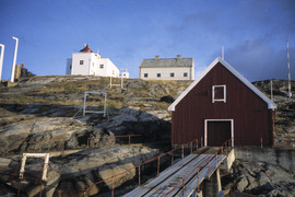
Bøkfjord lighthouse in Sør Varanger
-
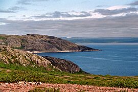
Jarfjord, seen from N886, Sør-Varanger
-
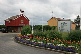
Svanhovd miljøsenter, Nasjonalparksenter, Bioforsk
-
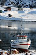
Hilde Kristin i vinteropplag


See also
 In Spanish: Sør-Varanger para niños
