San Simeon, California facts for kids
Quick facts for kids
San Simeon
|
|
|---|---|

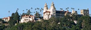
View of Hearst Castle
|
|
| Country | United States |
| State | California |
| County | San Luis Obispo |
| Area | |
| • Total | 0.797 sq mi (2.063 km2) |
| • Land | 0.797 sq mi (2.063 km2) |
| • Water | 0 sq mi (0 km2) 0% |
| Elevation | 230 ft (70 m) |
| Population
(2020)
|
|
| • Total | 445 |
| • Density | 558.3/sq mi (215.71/km2) |
| Time zone | UTC-8 (Pacific (PST)) |
| • Summer (DST) | UTC-7 (PDT) |
| ZIP codes |
93452
|
| Area code(s) | 805 |
| GNIS feature ID | 248966 |
San Simeon (in Spanish: San Simeón, meaning "St. Simon") is a small community on the Pacific coast of San Luis Obispo County, California, United States. It is not officially a city but an unincorporated community.
San Simeon is located along State Route 1, a famous scenic highway. It sits about halfway between the big cities of Los Angeles and San Francisco. Each city is roughly 230 miles (370 km) away.
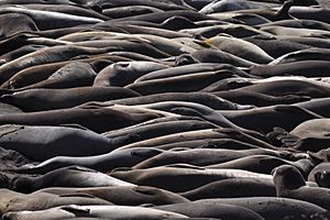
A major attraction here is Hearst Castle. This huge mansion was built for William Randolph Hearst in the early 1900s. It is now a very popular place for tourists to visit. The area is also famous for a large group of northern elephant seals. This group, called the Piedras Blancas rookery, lives about 7 miles (11 km) north of San Simeon on Highway 1.
Contents
History of San Simeon

People first lived in the San Simeon area at least 11,000 years ago. Before Europeans arrived, the Chumash people lived here. They had a large village south of San Simeon near Morro Creek.
In 1542, a Spanish explorer named Juan Cabrillo discovered the bay. He named it the Bay of Sardines.
The first European land exploration of Alta California happened in 1769. The Spanish Portolà expedition traveled along the coast. On September 11–12, they passed the future site of San Simeon.
San Simeon began as a small outpost for Mission San Miguel Arcángel. This mission was founded in 1797, east of San Simeon. The Bay of San Simeon is mentioned in the mission's records from 1830.
The area was named after Rancho San Simeon. However, the town itself is actually north of that rancho. It is on what used to be Rancho Piedra Blanca. This land was given to José de Jesús Pico in 1840. In 1865, Pico sold part of this land to George Hearst. He was the father of William Randolph Hearst.
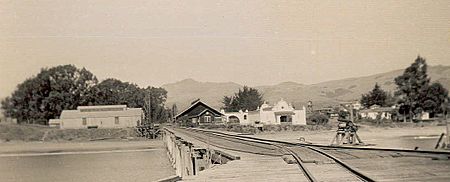
The first Europeans to settle near San Simeon Bay were Portuguese whalers. They arrived around 1864, led by Captain Joseph Clark. In 1869, Captain Clark built a wharf (a type of pier) for his whaling station.
A small community grew around this wharf. But the waves were too strong there, so the wharf was abandoned. In 1878, George Hearst built a new wharf. The community then moved closer to this new pier.
A general store, later known as Sebastian's Store, was built near the first wharf. It then moved to the new 1878 wharf. Whaling continued until the mid-1890s, stopped briefly, then started again until about 1908.
In 1953, the Hearst Corporation gave the William Randolph Hearst Memorial State Beach to San Luis Obispo County. This included the Hearst Pier. Today, it is part of Hearst San Simeon State Park. The pier you see today in San Simeon was built in 1957.
Geography and Climate
San Simeon is officially a "census-designated place" (CDP). This means it's an area defined by the government for counting people. It covers about 0.8 square miles (2.1 square kilometers) of land.
The original town of San Simeon is at San Simeon Bay. This was an important shipping point in the 1800s. San Simeon Acres is about 4 miles (6.4 km) south of the old town. It is halfway between old San Simeon and Cambria.
Most of San Simeon Acres was built between the 1960s and 1980s. Many motels and cafes are there to serve visitors going to Hearst Castle.
Weather in San Simeon
San Simeon and the Hearst Castle area have a warm-summer Mediterranean climate. This type of climate has warm, dry summers and mild, wet winters. The nearby Pacific Ocean helps keep the temperatures moderate. Weather records for San Simeon have been kept since December 1999.
| Climate data for San Simeon, California (Hearst Castle), 1999–2020 averages, extremes 1999–present | |||||||||||||
|---|---|---|---|---|---|---|---|---|---|---|---|---|---|
| Month | Jan | Feb | Mar | Apr | May | Jun | Jul | Aug | Sep | Oct | Nov | Dec | Year |
| Record high °F (°C) | 84 (29) |
83 (28) |
85 (29) |
95 (35) |
94 (34) |
102 (39) |
101 (38) |
102 (39) |
109 (43) |
100 (38) |
89 (32) |
80 (27) |
109 (43) |
| Mean maximum °F (°C) | 74.6 (23.7) |
73.9 (23.3) |
76.8 (24.9) |
81.9 (27.7) |
84.6 (29.2) |
91.0 (32.8) |
91.9 (33.3) |
94.7 (34.8) |
96.1 (35.6) |
90.9 (32.7) |
83.1 (28.4) |
72.1 (22.3) |
100.3 (37.9) |
| Mean daily maximum °F (°C) | 59.8 (15.4) |
59.5 (15.3) |
62.3 (16.8) |
64.9 (18.3) |
69.3 (20.7) |
72.9 (22.7) |
75.0 (23.9) |
77.3 (25.2) |
78.2 (25.7) |
74.0 (23.3) |
65.6 (18.7) |
58.9 (14.9) |
68.1 (20.1) |
| Daily mean °F (°C) | 53.2 (11.8) |
52.4 (11.3) |
54.6 (12.6) |
56.2 (13.4) |
60.5 (15.8) |
63.9 (17.7) |
66.1 (18.9) |
67.8 (19.9) |
69.1 (20.6) |
65.1 (18.4) |
58.0 (14.4) |
52.4 (11.3) |
59.9 (15.5) |
| Mean daily minimum °F (°C) | 46.5 (8.1) |
45.3 (7.4) |
46.9 (8.3) |
47.4 (8.6) |
51.6 (10.9) |
54.9 (12.7) |
57.1 (13.9) |
58.3 (14.6) |
60.0 (15.6) |
54.3 (12.4) |
50.3 (10.2) |
45.8 (7.7) |
51.5 (10.9) |
| Mean minimum °F (°C) | 36.5 (2.5) |
34.5 (1.4) |
36.4 (2.4) |
37.3 (2.9) |
41.3 (5.2) |
44.7 (7.1) |
47.3 (8.5) |
48.2 (9.0) |
46.9 (8.3) |
46.4 (8.0) |
40.0 (4.4) |
35.5 (1.9) |
32.4 (0.2) |
| Record low °F (°C) | 28 (−2) |
25 (−4) |
32 (0) |
34 (1) |
38 (3) |
42 (6) |
45 (7) |
46 (8) |
42 (6) |
42 (6) |
32 (0) |
32 (0) |
25 (−4) |
| Average precipitation inches (mm) | 5.96 (151) |
6.15 (156) |
4.80 (122) |
2.00 (51) |
0.71 (18) |
0.06 (1.5) |
0.08 (2.0) |
0.01 (0.25) |
0.07 (1.8) |
1.11 (28) |
2.34 (59) |
6.05 (154) |
29.34 (744.55) |
| Average precipitation days (≥ 0.01 in) | 7.6 | 8.9 | 7.3 | 5.2 | 2.4 | 0.3 | 0.2 | 0.2 | 0.5 | 3.3 | 4.6 | 8.4 | 48.9 |
| Source 1: NOAA | |||||||||||||
| Source 2: National Weather Service (mean maxima/minima 2006–2020) | |||||||||||||
Population and People
| Historical population | |||
|---|---|---|---|
| Census | Pop. | %± | |
| 2010 | 462 | — | |
| 2020 | 445 | −3.7% | |
| U.S. Decennial Census | |||

The United States Census Bureau counts San Simeon as a special area called a "census-designated place" (CDP). In 2010, the population of San Simeon was 462 people. By 2020, it was 445 people.
The people living in San Simeon come from many different backgrounds. In 2010, about 58.4% of the population was White. About 55.8% of the people were of Hispanic or Latino origin.
There were 197 households in San Simeon. About 26.9% of these households had children under 18 living there. Many households were married couples.
The average household had 2.34 people. The average family size was 3.00 people. About 22.9% of the population was under 18 years old. About 18.0% of the people were 65 years or older. The average age in San Simeon was 40.7 years.
Community Services
The San Simeon Community Services District provides important services for the area. These include water and sewerage (wastewater) services. A private company manages the wastewater treatment plant. This plant also handles sewage from Hearst Castle.
See also
 In Spanish: San Simeón (California) para niños
 | Sharif Bey |
 | Hale Woodruff |
 | Richmond Barthé |
 | Purvis Young |


