Sanders County, Montana facts for kids
Quick facts for kids
Sanders County
|
|
|---|---|

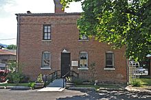
Historic Sanders County Jail in Thompson Falls, Montana
|
|

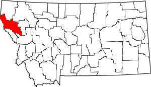
Location within the U.S. state of Montana
|
|
 Montana's location within the U.S. |
|
| Country | |
| State | |
| Founded | 1905 |
| Named for | Wilbur Fiske Sanders |
| Seat | Thompson Falls |
| Largest city | Thompson Falls |
| Area | |
| • Total | 2,790 sq mi (7,200 km2) |
| • Land | 2,761 sq mi (7,150 km2) |
| • Water | 29 sq mi (80 km2) 1.1% |
| Population
(2020)
|
|
| • Total | 12,400 |
| • Estimate
(2022)
|
13,442 |
| • Density | 4.444/sq mi (1.716/km2) |
| Time zone | UTC−7 (Mountain) |
| • Summer (DST) | UTC−6 (MDT) |
| Congressional district | 1st |
|
|
Sanders County is a county located in the state of Montana in the United States. In 2020, about 12,400 people lived there. The main town and county seat is Thompson Falls. Sanders County was created in 1905.
Every year, the county hosts a fun fair with a rodeo in Plains.
Contents
Geography of Sanders County
According to the United States Census Bureau, Sanders County covers a total area of 2,790 square miles. Most of this area, 2,761 square miles, is land. The remaining 29 square miles, or about 1.1%, is water.
Sanders County is located on Montana's western edge. It shares a border with Idaho to the west. The county is part of the Coeur d'Alene Mountains, which are a section of the Bitterroot Range. The Clark Fork River flows through the middle of the county. To the south are the Bitterroot Mountains, and to the north are the Cabinet Mountains.
The county's climate varies. The western mountain slopes get a lot of rain, almost 40 inches a year in Heron. This is similar to the amount of rain Seattle gets. However, the eastern part, like Dixon, gets much less rain, sometimes under 12 inches a year.
During the last ice age, a huge ice dam formed here. This dam held back a massive body of water called glacial Lake Missoula. When the ice dam broke, it caused huge floods. These floods created the unique Scablands in eastern Washington.
Neighboring Counties
- Lincoln County – to the north
- Flathead County – to the northeast
- Lake County – to the east
- Missoula County – to the southeast
- Mineral County – to the south
- Shoshone County, Idaho – to the west (Pacific Time Border)
- Bonner County, Idaho – to the northwest (Pacific Time Border)
Protected Natural Areas
- Kaniksu National Forest (part of it)
- Kootenai National Forest (part of it)
- Lolo National Forest (part of it)
- Bison Range (part of it)
Animals of Sanders County
Sanders County is home to many different birds and other wildlife. The Tufted duck has been seen along the Bull River. A special type of amphibian, the Rough-skinned Newt, lives in Thompson Falls. This group of newts is separate from other newt populations in the Western United States.
Sanders County is a popular place for wildlife viewing. You can find many large animals here. These include White-tailed Deer, Mule Deer, Rocky Mountain Elk, Shiras Moose, Mountain Goat, and Bighorn Sheep. Other animals like Black Bear, Cougar (mountain lion), and Wolves also live in the area.
Grizzly bears, which are Montana's state animal, also live in the county. However, they are an endangered species, so hunting them is not allowed. The Western Meadowlark, Montana's state bird, can be found in the county's meadow areas. Redwing Blackbirds and Mountain Bluebirds are also common.
The westslope cutthroat trout is a fish native to the rivers and streams of Sanders County. Another threatened native fish, the bull trout, eats these cutthroat trout. To help these native fish populations, people are encouraged to practice catch-and-release fishing. These native fish now compete with other fish that have been introduced. These include rainbow trout, largemouth bass, yellow perch, Northern Pike, and walleyes. These new fish thrive in the changed habitats of the Clark Fork River's reservoirs.
Plants of Sanders County
Sanders County is in the mountainous western part of Montana. It is covered mostly by a mixed coniferous forest. Douglas fir and Ponderosa pine, which is Montana's state tree, are very common. Many other types of conifers also grow here in areas that suit them. These include Western red cedar, Western Hemlock, Mountain Hemlock, White Spruce, Subalpine Fir, Grand Fir, Western White Pine, and Lodgepole Pine. One of the most beautiful is the Western larch. This is a special type of conifer that turns gold in the fall before losing its needles.
Many broadleaf trees also grow in Sanders County. These include Rocky Mountain Maple, Red Alder, Paperbark Birch, Chokecherry, cottonwood, and poplar.
Perhaps the most popular broad-leaf shrub in Sanders County is the Rocky Mountain huckleberry. Trout Creek is known as the "Huckleberry Capital of Montana." It holds an annual huckleberry festival in August. Even though it is related to the common blueberry, it is very hard to grow Rocky Mountain huckleberry at home. It often grows with beargrass, a plant found in areas of the mountains that have been burned or logged.
The bitterroot, Montana's state flower, can also be found in limited amounts in Sanders County.
Population of Sanders County
| Historical population | |||
|---|---|---|---|
| Census | Pop. | %± | |
| 1910 | 3,713 | — | |
| 1920 | 4,903 | 32.0% | |
| 1930 | 5,692 | 16.1% | |
| 1940 | 6,926 | 21.7% | |
| 1950 | 6,983 | 0.8% | |
| 1960 | 6,880 | −1.5% | |
| 1970 | 7,093 | 3.1% | |
| 1980 | 8,675 | 22.3% | |
| 1990 | 8,669 | −0.1% | |
| 2000 | 10,227 | 18.0% | |
| 2010 | 11,413 | 11.6% | |
| 2020 | 12,400 | 8.6% | |
| 2022 (est.) | 13,442 | 17.8% | |
| U.S. Decennial Census 1790–1960 1900–1990 1990–2000 2010–2020 |
|||
2020 Census Information
In 2020, the census showed that 12,400 people lived in Sanders County.
2010 Census Information
In 2010, the census counted 11,413 people living in the county. There were 5,121 households and 3,204 families. The population density was about 4.1 people per square mile. There were 6,678 housing units, with an average of 2.4 units per square mile.
Most of the people in the county were white (91.6%). About 4.4% were American Indian, and 0.3% were Asian. About 0.1% were black or African American. About 0.4% were from other races, and 3.1% were from two or more races. People of Hispanic or Latino origin made up 2.0% of the population.
When it came to ancestry, many people had German roots (32.2%). Others had English (16.4%), Irish (16.1%), Norwegian (9.1%), or Swedish (6.3%) ancestry. About 3.3% identified as American ancestry.
Of the 5,121 households, 22.4% had children under 18 living with them. About 52.8% were married couples. About 6.2% had a female head of household with no husband present. Around 37.4% were not families, and 32.8% of all households were single individuals. The average household size was 2.19 people, and the average family size was 2.75 people. The average age of people in the county was 49.8 years old.
The average income for a household in the county was $30,622. For a family, the average income was $37,514. Men earned an average of $32,857, while women earned $22,274. The income per person in the county was $18,472. About 16.6% of families and 21.3% of the population lived below the poverty line. This included 33.9% of those under 18 and 11.1% of those aged 65 or older.
Transportation in Sanders County
The Hot Springs Airport is an airport owned by the county. It is open for public use and is located east of Hot Springs.
Towns and Communities
Cities in Sanders County
- Thompson Falls (This is the county seat, where the main government offices are located)
- Population: 1,336
Towns in Sanders County
- Hot Springs
- Population: 557
- Plains
- Population: 1,106
Census-Designated Places
These are areas that are like towns but are not officially incorporated as cities or towns.
- Belknap
- Population: 161
- Camas
- Population: 57
- Sčilíp
- Population: 221
- Heron
- Population: 173
- Lonepine
- Population: 177
- Niarada (partially in the county)
- Population: 28
- Noxon
- Population: 255
- Old Agency
- Population: 81
- Paradise
- Population: 166
- Trout Creek
- Population: 277
- Weeksville
- Population: 81
Unincorporated Communities
These are small communities that do not have their own local government.
- Bend
- Camas Prairie
- Donlan
- Eddy
- Larchwood
- Perma
- Quinns
- Talc
- Tuscor
- White Pine
See also
 In Spanish: Condado de Sanders para niños

