
Scheduled monuments in Greater Manchester facts for kids
There are 37 special historic places in Greater Manchester called scheduled monuments. Greater Manchester is a big area in North West England. In the UK, a scheduled monument is a very important old place or building, like an archaeological site, that is protected by the government. This protection stops people from changing it without permission. These places are chosen by Historic England and then officially listed by the Secretary of State. There are almost 20,000 such places across the UK! Sometimes, a scheduled monument can also be a listed building, which means it's also protected for its special architecture.
Greater Manchester is made up of 10 areas called metropolitan boroughs: Bolton, Bury, Manchester, Oldham, Rochdale, Salford, Stockport, Tameside, Trafford and Wigan. Interestingly, Rochdale doesn't have any scheduled monuments. The monuments in the other boroughs are listed below. They include everything from very old structures, like those from the Bronze Age (thousands of years ago), to more recent ones like the Astley Green Colliery from 1908.
Greater Manchester has seven monuments from the Bronze Age or Iron Age (even older times!). You can find these in Bury, Oldham, Salford, Stockport, and Tameside. The Bronze Age sites are mostly cairns (piles of stones) and barrows (mounds of earth), which were often used for burials. The two Iron Age sites are promontory forts, which were military strongholds.
The idea of military sites continued into the Roman times. Two Roman forts in Greater Manchester are scheduled monuments. These were the main places where the Romans were active in the area. Out of nine castles in Greater Manchester, four are scheduled monuments: Buckton Castle, Watch Hill Castle, Bury Castle, and Radcliffe Tower. The last two were like fortified manor houses, meaning they were strong homes, not just military forts. They probably also served as important centers for the local area. Many other manor houses and country homes, some with moats (ditches filled with water for defence), are also protected. Places like the Astley Green Colliery, the Marple Aqueduct, Oldknows Limekilns, and the Worsley Delph are protected because they show Greater Manchester's important industrial past.
Contents
Monuments in Bolton
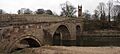
Ringley Old Bridge
This stone bridge crosses the River Irwell. It was built in 1677 to replace an older bridge that was washed away. Today, it's only used by people walking or cycling. It's also a Grade II* listed building, meaning it's very important historically.
Smithills Hall

Smithills Hall was first built in the early 1300s. It was made bigger in the 1400s and 1500s. The oldest part you can still see is the great hall, from the early 1400s. The hall used to have a moat around it, but you can't see it anymore. Smithills Hall is now a Grade I listed building and is open to the public as a museum.
Monuments in Bury
Affetside Cross

This stone pillar was once a cross. It replaced an older medieval marker in the 1600s or 1700s. The pillar stands on three round steps, which were likely added in 1890 when the cross was repaired.
Bury Castle
Bury Castle was a manor house built in 1469. It replaced an even older building from the late 1300s. Sir Thomas Pilkington built it and got permission from the king to make it strong like a castle. But when Sir Thomas supported the losing side in the War of the Roses, the castle was torn down. Some parts of the castle have been dug up and you can see them today.
Castlesteads
Castlesteads is an promontory fort located by the River Irwell. A promontory fort is a type of fort built on a piece of land that sticks out, making it naturally protected on some sides. This site is protected by a 120-meter (390 ft) long and 6-meter (20 ft) wide ditch. The inside of the fort is shaped like a triangle. Old pottery found here shows people lived there from 200 BC to 250 AD.
Radcliffe Tower

Radcliffe Tower is the only part left of a medieval manor house that belonged to James de Radliffe. It was a stone hall with two towers and a moat around it. The house was made stronger with crenellations (gaps at the top of walls for defence) and battlements, with the king's permission. The rest of the manor house was taken down in the 1800s. The tower is now a Grade I listed building.
Monuments in Manchester
Baguley Hall

The original building might have been from the 1000s or 1100s. But the current timber-framed house is from the 1300s. The old north wing was covered with bricks later. In the 1700s, a new brick south wing was added. Baguley Hall is considered one of the best medieval halls still standing in the northwest of England. It is a Grade I listed building.
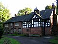
Clayton Hall

This hall probably dates back to the 1400s. It might have been a square building or had three wings. Much of the hall was taken down in the 1600s and replaced with a new house. Clayton Hall was changed and fixed up again in the 1700s and in 1900. The hall is on a rectangular island surrounded by a moat and is a Grade II* listed building.
Hanging Bridge

The bridge we see today was built in 1421, but it was first mentioned in 1343. This bridge is 33 meters (108 ft) long and 2.7 meters (9 ft) wide. It crossed Hanging Ditch and was part of Manchester's defences in medieval times. The bridge was hidden by houses in the 1770s as Manchester grew. It was found again in the 1880s and in the late 1900s. Now, you can see it in Manchester Cathedral's visitor centre.
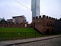
Mamucium
Mamucium was a Roman fort built in 79 AD. It was located on a sandstone cliff near the River Medlock. This fort was part of a Roman road between Chester and York. It was built to house 500 Roman soldiers. A town of traders and families grew up around the fort. Around 140 AD, the fort was taken down, and the town was left empty. But the fort was rebuilt in 160 AD, and people moved back to the town. It was abandoned by the mid-200s, but the fort was used until the early 300s. You can visit a part of the fort that has been rebuilt today.
Nico Ditch

Nico Ditch is a long earthwork (a ditch dug into the ground) that stretches from Ashton Moss in the east to Hough Moss in the west. A legend says the ditch was dug in one night to defend against Viking invaders in 869–870. However, the shape of the ditch suggests it wasn't for defence. It was probably used to mark a boundary between different areas. The ditch can still be seen in parts, and it's about 1.5 meters (5 ft) deep and up to 4 meters (13 ft) wide in some places.
Peel Hall
Peel Hall was built in the mid-1300s by Sir John de Arderne. The site is surrounded by a moat that is between 8 and 14 meters (26 and 46 ft) wide and 1.2 meters (4 ft) deep. Peel Hall was taken down in 1809 and replaced by a farmhouse. That farmhouse was also taken down in 1975.
Monuments in Oldham
Castleshaw Roman fort

In 79 AD, the Romans built a fort at Castleshaw. It was for 500 soldiers and was part of their border defences along the road between Chester and York. It was partly destroyed in 90 AD. But a smaller fort, or "fortlet," was built there in 105 AD for fewer than 100 soldiers. A town of traders grew around the fort in the 100s. The fortlet was abandoned in the mid-120s when other forts became more important. The town was also abandoned around the same time. You can still see ditches and earthworks that mark the site.
Saddleworth Bowl Barrow
A barrow is a mound of earth, often used for burials. This barrow is oval-shaped, measuring 17 meters (19 yd) by 18 meters (20 yd) and is 0.5 meters (1.6 ft) high. Archaeologists have dug here, but they haven't found any burial items or human remains. The site is still in good condition.
Monuments in Salford
Iron Age promontory fort
This promontory fort is surrounded by two ditches. Inside the fort, there are four round areas that were probably used for industry or keeping animals. Pottery found here is the only proof of an old pottery industry in Greater Manchester from prehistoric times.
Worsley Delph

In 1759, people started building a system of underground canals here. These canals helped transport coal from Worsley Colliery to the Bridgewater Canal. They were used until 1887. The canals closed completely after the last coal mine in the area shut down in 1968.
Monuments in Stockport
Brown Low
Brown Low is a bowl barrow, which is a round burial mound. It's 25.5 meters (84 ft) across and 2 meters (6.6 ft) high. The site is covered in grass. Two hollows on the barrow are from an excavation that happened in 1809.
Cairn (Ludworth)
This cairn (a mound of stones) from the late Bronze Age is 12 meters (39 ft) across and 0.4 meters (1.3 ft) high. It has several chambers and places where cremated remains were buried. Because it's on a hill, it's easy to see.
Marple Aqueduct

The Marple Aqueduct was built between 1794 and 1801. Its job was to carry the Peak Forest Canal over the River Goyt. This aqueduct is still used today by boats for fun.
Oldknows Limekilns
Between 1797 and 1800, Samuel Oldknow built three lime kilns here. Lime kilns are ovens used to heat limestone to make lime, which was used in building and farming. The kilns are 11 meters (36 ft) deep and were built into the hillside. They were used until the 1900s. The remaining walls of the kilns are protected as a Grade II listed building.
Peel Moat
This is a dried-up, rectangular moat that surrounded a square fortified tower. There are no parts of the tower left above ground. The tower was on a piece of land 29 meters (95 ft) square, and the moat around it was between 5.5 meters (18 ft) and 10 meters (33 ft) wide.
Torkington Moat
This moat in Torkington is filled with water. It surrounds the place where a manor house was first built in 1350. The moat is 1.6 meters (5.2 ft) deep and between 8 and 20 meters (26 and 66 ft) wide. It forms the edge of an island that is 46 meters (151 ft) by 43 meters (141 ft). Torkington Hall, a newer building, replaced the medieval manor house in the early 1600s.
Monuments in Tameside
Buckton Castle

Buckton Castle is an enclosure castle that was probably built by the earls of Chester in the 1100s. It might have been built to protect the Longdendale Valley. The castle was first mentioned in 1360, when it was already falling apart. The castle is circular, measuring 35 meters (115 ft) by 45 meters (148 ft). It's surrounded by a 10-meter (33 ft) wide and 6-meter (20 ft) deep ditch. Buckton Castle has been damaged by people looking for treasure in the 1700s and by quarrying (taking stone from the ground) in the 1800s and 1900s.
Cairn (Stalybridge)
This round cairn (mound of stones) is covered in grass and sits on top of a hill. It's a mound of stones with a flat top, 1 meter (3.3 ft) high and 16 meters (52 ft) across. Part of the southern edge has been destroyed. Modern changes include a stone wall and a pillar for surveying.
Monuments in Trafford
Watch Hill Castle
This castle is a motte-and-bailey type. This means it has a conical mound (the "motte") that is 40 meters (130 ft) across and 17 meters (56 ft) high. Around it is a triangular lower area (the "bailey") that covers 2400 square meters (0.6 acres). It probably belonged to Hamon de Massey, a powerful baron in the 1100s. The castle was no longer used by the 1200s.
Monuments in Wigan
Astley Green Colliery

The Pilkington Colliery Company started building this coal mine in 1908. It began producing coal in 1912. The colliery closed in 1970 and is now the Astley Green Colliery Museum. Most of the buildings and one of the mine shafts have been destroyed.
Cross bases (Standish)
There are three stone cross bases in Standish. These crosses were part of four known crosses that marked the old medieval road from Wigan to Chorley. Some of them have been moved from their original spots when roads were made wider. One of them is also a Grade II listed building.
Gidlow Hall
The current building is from around 1574, but it probably replaced an older one. In 1840, the hall was rebuilt in the Gothic Revival style, which means it looked like older Gothic buildings. Gidlow Hall is protected as a Grade II listed building.
The Great Haigh Sough Portal
Between 1653 and 1670, the Haigh Sough drainage system was built. Its purpose was to drain water from the local coal mines. The system is 936 meters (3,071 ft) long and has only one entrance. It was used until 1929. The entrance is now covered by a steel grille to stop people from going inside.
Mab's Cross

Mab's Cross is a stone cross stub from the 1200s. It was one of four crosses that marked the medieval road from Wigan to Chorley. In 1922, the cross was moved when the road was widened. It is protected as a Grade II* listed building.
Standish Market Cross
The base of this stone cross is medieval, but the cross part itself is modern. It is protected as a Grade II listed building.
Moat of Moat House
All that's left here is a dried-up square moat that surrounded the 1700s Moat House.
Morleys Hall
The current hall was built in the 1800s, but it includes some timber framing from the 1500s and 1600s. In 1641, it was the home of Ambrose Barlow. The site is surrounded by a 12 to 15 meter (39 to 49 ft) wide and 3 meter (9.8 ft) deep moat that is filled with water. Morleys Hall is a Grade II* listed building.
New Hall moated site
This moat surrounds the place where an original medieval building stood. That building was later replaced by a farmhouse. The moat is filled with water, but the ruined farmhouse is not part of the protected monument.
Winstanley Hall

Winstanley Hall was built in the 1560s for the Winstanley family, who were important local landowners. It's connected to other nearby halls like Bispham Hall (1573), Birchley Hall (1594), and Hacking Hall (1607). Winstanley Hall was made bigger in the 1600s and 1700s, and more work was done in the 1800s, including by architect Lewis Wyatt in the Jacobean style. The building is currently in a bad state and is empty. It is also a Grade II* listed building.
Images for kids
-
Ringley Old Bridge in Ringley
-
Clayton Hall, in Clayton
-
A reconstructed section of the wall of Mamucium fort


