
Scheduled monuments in West Somerset (A–G) facts for kids
West Somerset was a local government area in the English county of Somerset. It joined with Taunton Deane to create Somerset West and Taunton on April 1, 2019.
Contents
Amazing Ancient Places in West Somerset
West Somerset is full of fascinating historical sites. These places tell us about people who lived here long, long ago. From ancient burial mounds to old bridges and forts, there's a lot to explore!
Mysterious Burial Mounds and Stone Rows
Many ancient people buried their dead in special ways. In West Somerset, you can find many burial mounds and stone rows from the Bronze Age and Neolithic periods. These were built thousands of years ago!
Alderman's Barrow
Near Exford, you can find Alderman's Barrow. This is a large bowl barrow, which is a type of burial mound shaped like a bowl. It's about 24 meters (79 feet) wide! It was built during the Bronze Age.
.jpg)
Almsworthy Common Stone Alignment
Also near Exford, there's a cool stone row on Almsworthy Common. This site has four rows of standing stones. There are 14 stones in total, ranging from 10 centimeters (4 inches) to 70 centimeters (28 inches) tall. These mysterious stones were put here between the late Neolithic and middle Bronze Age.
.jpg)
Black Barrow
On Exmoor, you can see Black Barrow. This is a round barrow, another type of burial mound. It's about 22 meters (72 feet) wide and 1.5 meters (5 feet) high. It dates back to the Bronze Age.

Brightworthy Barrows
On Withypool Common, there are two bowl barrows called Brightworthy Barrows. One of them is even used as a triangulation station by the Ordnance Survey! These mounds are from the late Neolithic to the Bronze Age.

Dunkery Beacon
Dunkery Beacon is the highest point on Exmoor and in Somerset. It has several ancient burial mounds nearby. These mounds are from the Bronze Age. The land, including Dunkery Beacon, was given to the National Trust in 1935.
Caratacus Stone
Near Winsford, you can find the Caratacus Stone. This is a special Celtic inscribed stone from the 6th century. It has an inscription in Latin that means "grandson or immediate descendant of Caratacus." People think it was a memorial to someone related to the famous British chieftain Caratacus. The stone has been known since at least 1219!

Ancient Forts and Settlements
Many hills in West Somerset were once home to ancient forts and settlements. These were often built on high ground for defense.
Bat's Castle
Bat's Castle is an Iron Age hill fort located on top of a 213-meter (699-foot) high hill near Carhampton. It has two stone walls and two ditches that helped protect it. It might be connected to another nearby fort called Black Ball Camp.

Black Ball Camp
Also an Iron Age hill fort, Black Ball Camp is on Gallox Hill near Dunster. It has a 3-meter (10-foot) high wall and a 2-meter (7-foot) deep ditch. It's also known as British Camp and might be linked to Bat's Castle.

Bury Castle (Brompton Regis)
There are two places called Bury Castle! This one, near Brompton Regis, was an Iron Age hillfort that was later used as a castle in the 12th century. During a civil war, a "motte and bailey" castle was built here. A motte is a raised earth mound, and a bailey is a walled courtyard.
Bury Castle (Selworthy)
The other Bury Castle is an Iron Age enclosure near Selworthy. It covers about 0.21 hectares (0.52 acres) and is surrounded by a bank and ditch.

Clatworthy Camp
Clatworthy Camp is an Iron Age hillfort on the Brendon Hills, overlooking Clatworthy Reservoir. It's shaped like a triangle and covers about 5.8 hectares (14 acres). It has a single bank and ditch carved out of solid rock.
Cow Castle
Cow Castle is another Iron Age hillfort on Exmoor, located in the valley of the River Barle. It sits on an isolated hilltop and has a single wall and ditch, covering about 0.9 hectares (2.2 acres). It's on the "Heritage at Risk" list because of bracken growing there.

Daw's Castle
Daw's Castle is a special hillfort on a sea cliff west of Watchet. It's about 80 meters (262 feet) above the sea! It might have been an Iron Age fort, but it was definitely rebuilt and strengthened by King Alfred around 878 AD. He used it as part of his defense against Vikings raiding from the Bristol Channel.

Historic Buildings and Structures
West Somerset also has many interesting buildings and structures from more recent history, like medieval times.
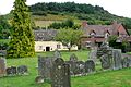
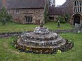
Agnes Fountain
In Selworthy, you can find Agnes Fountain, a medieval holy well. It's made from stone slabs and has been there since the Middle Ages.

Allerford New Bridge
The Allerford New Bridge near Luccombe is a medieval stone bridge. It was largely rebuilt in 1630 and again in 1866. It crosses the Horner Water.
Allerford Packhorse Bridge
The Allerford packhorse bridge crosses the River Aller. It's thought to be from the Middle Ages. It was originally 3.7 meters (12 feet) wide, but another 1.8 meters (6 feet) was added in 1866.

Barle Bridge
The Barle Bridge in Dulverton is a medieval stone bridge with five arches over the River Barle. It was made wider in 1819 and fixed again after floods in the 1950s.

Barlinch Priory
Barlynch Priory was an Augustinian priory founded between 1154 and 1189 near Brompton Regis. It was closed in 1537. Today, only some wall fragments remain near Barynch farmhouse. Some of its beautiful stained glass is now in St Peter's Church in Huish Champflower.
Burrow Farm Iron Mine
Near Brompton Regis, you can see the remains of the Burrow Farm iron mine. This mine was active in the 19th century, starting around 1863. The West Somerset Mineral Railway was built to carry iron ore from the Brendon Hills to Watchet for shipping. You can still see the old beam engine house!

Bury Bridge
Bury Bridge is a medieval stone Packhorse bridge near Brompton Regis. It has four arches and carries a small track over the River Haddeo.

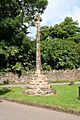
Dunster Butter Cross
The Butter Cross in Dunster is a wayside cross from the late 14th or early 15th century. It has an octagonal base and shaft. It used to be in the High Street, maybe near the Yarn Market, but was moved to its current spot.

Cleeve Abbey
Cleeve Abbey near Washford was a medieval monastery founded in the late 12th century for Cistercian monks. In 1536, Henry VIII closed it during the Dissolution of the Monasteries, and it became a country house. Later, it was used as farm buildings. Now, English Heritage looks after it, and you can visit! The church is gone, but the other buildings still have roofs and cool features like the "angel" roof in the refectory and wall paintings.

Dunster Dovecote
The Dunster Dovecote was likely built in the late 16th century. It's a round building about 5.8 meters (19 feet) high and wide, with thick walls. It has 540 nest-holes for pigeons! In the 18th century, changes were made to protect against Brown Rats. A spinning ladder called a "potence" was added to help reach the nests.

Blackford Farm Dovecote
The Dovecote at Little Blackford near Selworthy was built in the 11th century. It's now owned by the National Trust and used as a farm store. It's made of local Devonian sandstone and has over 300 nest holes for pigeons.

Gallox Bridge
The Gallox Bridge is a narrow stone packhorse bridge on the edge of Dunster. It has two arches over the River Avill. It's about 13.5 meters (44 feet) long and was built in the 15th century. English Heritage helps to protect it.

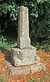
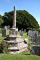
Churchyard Crosses
Many churches in West Somerset have old stone crosses in their churchyards. These were often built in the Middle Ages.
Bicknoller Churchyard Cross
The churchyard cross in Bicknoller was built in the late 14th century. It has an octagonal shaft on a three-step base.

Crowcombe Churchyard Cross
The churchyard cross at Holy Ghost Church in Crowcombe is a medieval cross. Its octagonal shaft is 2.8 meters (9 feet) high and sits on a three-step base.

Watchet Churchyard Cross
The churchyard cross at St Decuman's Church in Watchet is from the 14th or 15th century. It has a tapering octagonal stone shaft on an octagonal base. The top part was restored with wood in the mid-20th century.

Treborough Churchyard Cross
The churchyard cross at St Peter's Church in Treborough is a medieval cross. It has a stone shaft on an octagonal base with three steps. The head of the cross, with a figure of St Peter, was added in the 19th century.

Images for kids
-
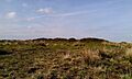
A bowl barrow and round cairn on Withypool Hill.
-
Thorncombe Barrow, a bowl barrow.
-
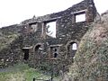
The derelict wheelhouse at Carnarvon New Pit iron mine.
-
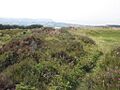
A stone cist in Langridge Wood.
-
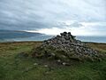
A cairn on Bossington Hill.
-
The churchyard cross in Luccombe.
-
Remains of the churchyard cross in Dunster.
-
Remains of the churchyard cross at St Peter's Church, Williton.
-
The churchyard cross at All Saints' Church, Selworthy.
-
The village cross in Crowcombe.
-
Great Rowbarrow, a Bronze Age cairn.
-
A group of round barrows.

.jpg)
.jpg)
.jpg)

.jpg)
.jpg)


.jpg)
.jpg)
