Sierra Ancha facts for kids
The Sierra Ancha is a mountain range in central Arizona. Its name means "broad range" in Spanish. In the Western Apache language, it's called Dził Nteel, which means "Wide Flat Mountain."
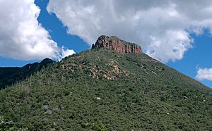
This mountain range is in Gila County, Arizona, and sits between Theodore Roosevelt Lake to the south and the Tonto Basin to the west. To the east is Cherry Creek, and to the north is Pleasant Valley. The Sierra Ancha is part of a special "transition zone" in Arizona. This zone connects the hot, low deserts of southern Arizona with the higher, cooler Colorado Plateau in the northeast. The tallest point in the range is Aztec Peak, which stands at 2,345 meters (7,694 feet) high.
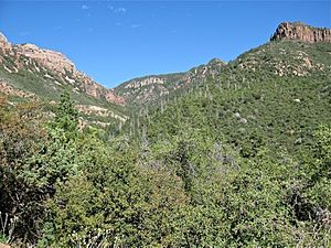
Not many main roads go into the Sierra Ancha. Instead, you'll find many deep and amazing canyons, especially on the eastern side. There isn't much farming, businesses, or homes here. In the past, people mined for asbestos in one area. Today, cattle ranching is still a common activity. Nearby towns include Roosevelt, Tonto Basin, Punkin Center, and Young. The entire Sierra Ancha range is located inside Arizona's Tonto National Forest.
The Sierra Ancha is home to two special protected areas called U.S. Wilderness Areas. These are the Salome Wilderness, which includes Salome Creek and its canyon, and the Sierra Ancha Wilderness, which protects the tall peaks and deep canyons on the eastern side. There's also the Sierra Ancha Experimental Forest, where scientists study how water flows in the Southwestern United States.
This area is rich in archaeological sites, especially cliff dwellings hidden in the rugged canyons that open towards Cherry Creek. We don't know for sure who built these ancient homes, but they show features of both the Salado culture and Mogollon culture. Scientists used tree rings from the roof beams to figure out that construction started around 1280 AD. The homes were then left empty by 1350 AD.
Nature and Wildlife
The Sierra Ancha has important streams like Workman Creek and Salome Creek. The types of plants you see change as you go higher up the mountains.
Plants of Sierra Ancha
- Lower areas (650–1,000 meters or 2,133–3,281 feet): Here, you'll find plants typical of the Sonoran Desert. These include tall saguaro cacti, green palo verde trees, and creosote bush.
- Middle areas (1,200–1,800 meters or 3,937–5,906 feet): In these elevations, you'll mostly see oak trees and juniper bushes.
- Higher areas (above 1,829 meters or 6,000 feet): The highest parts of the Sierra Ancha have large forests of ponderosa pine trees. On the coolest slopes, you can also find Douglas fir trees.
A special plant called coastal woodfern (Dryopteris arguta) grows here. It's usually found closer to the Pacific Ocean. Its presence in the Sierra Ancha shows that the higher parts of the range have a surprisingly humid (moist) climate.
| Climate data for Sierra Ancha, Arizona Altitude: 5,100 feet (1,550 m) |
|||||||||||||
|---|---|---|---|---|---|---|---|---|---|---|---|---|---|
| Month | Jan | Feb | Mar | Apr | May | Jun | Jul | Aug | Sep | Oct | Nov | Dec | Year |
| Record high °F | 76 | 79 | 84 | 91 | 97 | 105 | 104 | 103 | 103 | 96 | 83 | 78 | 105 |
| Mean daily maximum °F | 53.0 | 56.7 | 61.6 | 69.9 | 78.1 | 88.5 | 91.5 | 89.0 | 85.2 | 75.0 | 62.9 | 54.9 | 72.2 |
| Mean daily minimum °F | 30.3 | 32.6 | 35.6 | 41.7 | 48.5 | 57.7 | 62.6 | 61.7 | 58.3 | 48.4 | 37.6 | 31.8 | 45.6 |
| Record low °F | 0 | 10 | 11 | 16 | 22 | 30 | 34 | 38 | 29 | 20 | 12 | 2 | 0 |
| Average precipitation inches | 3.29 | 2.57 | 2.78 | 1.24 | 0.53 | 0.45 | 2.95 | 3.46 | 2.10 | 1.96 | 1.90 | 3.29 | 26.52 |
| Average snowfall inches | 7.1 | 4.2 | 3.5 | 0.7 | 0.5 | 0.0 | 0.0 | 0.0 | 0.0 | 0.0 | 0.6 | 3.8 | 20.4 |
| Record high °C | 24 | 26 | 29 | 33 | 36 | 41 | 40 | 39 | 39 | 36 | 28 | 26 | 41 |
| Mean daily maximum °C | 11.7 | 13.7 | 16.4 | 21.1 | 25.6 | 31.4 | 33.1 | 31.7 | 29.6 | 23.9 | 17.2 | 12.7 | 22.3 |
| Mean daily minimum °C | −0.9 | 0.3 | 2.0 | 5.4 | 9.2 | 14.3 | 17.0 | 16.5 | 14.6 | 9.1 | 3.1 | −0.1 | 7.6 |
| Record low °C | −18 | −12 | −12 | −9 | −6 | −1 | 1 | 3 | −2 | −7 | −11 | −17 | −18 |
| Average precipitation mm | 84 | 65 | 71 | 31 | 13 | 11 | 75 | 88 | 53 | 50 | 48 | 84 | 673 |
| Average snowfall cm | 18 | 11 | 8.9 | 1.8 | 1.3 | 0.0 | 0.0 | 0.0 | 0.0 | 0.0 | 1.5 | 9.7 | 52.2 |
| Average precipitation days (≥ 0.01 in) | 7 | 6 | 6 | 3 | 2 | 2 | 9 | 10 | 6 | 4 | 4 | 6 | 65 |
| Source: WRCC | |||||||||||||
How the Mountains Formed
The Sierra Ancha mountains show off some very old rocks, part of what geologists call the Apache Group. This group includes different types of rock like conglomerate (rocks made of pebbles and gravel), shale, limestone, and quartzite. These rocks also have large amounts of diabase mixed in.
The purplish Dripping Spring Quartzite and the white-pinkish Troy Quartzite are much harder than the rocks around them. Because they resist weathering (breaking down by wind and water), they form the amazing cliffs you see in the Sierra Ancha. For example, in lower Parker Canyon, the Dripping Springs Quartzite forms cliffs that drop 200 meters (656 feet) straight down! The light-colored cliffs at the top of upper Parker Canyon are made from the Troy Quartzite.
The very bottom layer of rock in the whole range is a type of Granite called Ruin Granite. The top of Aztec Peak is covered with a coarse, brown sandstone rock. This sandstone is similar to the Tapeats Sandstone found in the Grand Canyon. In the Grand Canyon, the Tapeats Sandstone is found at about 850 meters (2,789 feet) high. But at Aztec Peak, it's found at about 2,350 meters (7,710 feet) high. This big difference in height (about 1,500 meters or 4,921 feet) tells us that the Sierra Ancha area was once much higher than it is today. It also means that layers of rock that are still present in the Grand Canyon have been worn away by erosion in the Sierra Ancha.
See also
 In Spanish: Sierra Ancha para niños
 | Sharif Bey |
 | Hale Woodruff |
 | Richmond Barthé |
 | Purvis Young |


