St. Albans (city), Vermont facts for kids
Quick facts for kids
St. Albans, Vermont
|
|
|---|---|
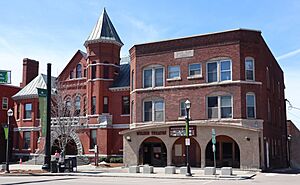
St. Albans City Hall and Welden Theatre on Main Street
|
|
| Nickname(s):
Railroad City of Vermont
|
|
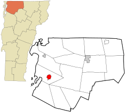
Location in Franklin County and the state of Vermont.
|
|
| Country | United States |
| State | Vermont |
| County | Franklin |
| Settled | 1783 |
| Organized (town) | 1785 |
| Chartered (city) | 1896 |
| Area | |
| • Total | 2.03 sq mi (5.25 km2) |
| • Land | 2.03 sq mi (5.25 km2) |
| • Water | 0.00 sq mi (0.00 km2) |
| Elevation | 200 ft (61 m) |
| Population
(2020)
|
|
| • Total | 6,877 |
| • Density | 3,387.68/sq mi (1,309.90/km2) |
| Time zone | UTC−5 (EST) |
| • Summer (DST) | UTC−4 (EDT) |
| ZIP code |
05478
|
| Area code(s) | 802 |
| FIPS code | 50-61675 |
| GNIS feature ID | 1462196 |
| Website | www.stalbansvt.com |
St. Albans is a city in Franklin County, Vermont, United States. It is the main city of the county. In 2020, about 6,877 people lived there.
St. Albans City is completely surrounded by St. Albans Town. The town is a separate place. The city is in northwestern Vermont. It is about 29 miles north of Burlington. Burlington is Vermont's largest city.
Contents
History of St. Albans, Vermont
St. Albans was first given its charter on August 17, 1763. This was done by Governor Benning Wentworth. The city is named after St Albans in Hertfordshire, England.
The first person to settle here was Jesse Welden. This happened during the American Revolution. The war stopped more people from moving here until 1785. After that, more pioneers came from southern New England.
Farming and Railroads in St. Albans
Farmers found the land in St. Albans very good for growing crops. It was also great for raising animals like cattle, horses, and sheep. A lot of butter and cheese were made here.
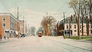
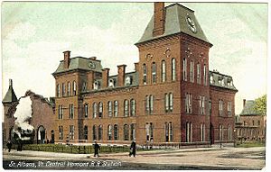
St. Albans also became known as "The Rail City." This was because it had a big train depot. It was also a center for train operations and repairs. This was for the Vermont and Canada Railroad.
When the village became a city in 1859, it had many businesses. These included an iron foundry and a factory that made freight cars. There were also many mechanic shops.
Important Events in St. Albans
The St. Albans Raid happened here on October 19, 1864. This was the northernmost battle of the American Civil War.
In 1869, a group of nuns called the Congrégation de Notre Dame started a school here. It was called Villa Barlow Convent and St. Mary High School.
In 1902, St. Albans officially became a city. It covered about two square miles within the town of St. Albans.
St. Albans Today
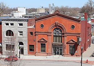
Today, St. Albans is a place many tourists visit. It is known for its beautiful buildings. Many of these buildings were built when the railroad was very busy. More than 200 trains passed through the city every day back then.
St. Albans is also important for people studying genealogy. This is because many European immigrants came to the United States through Canada. They would land in places like Halifax, Nova Scotia or Montreal, Quebec. Then, they would take a train through the border to St. Albans. From here, some traveled to other parts of Vermont, New York, or further west. The National Archives has records for St. Albans from 1895 to 1954.
Culture and Events in St. Albans
In late April, St. Albans holds its yearly Vermont Maple Festival. This festival has many food contests. It also includes the Sap Run. This is a footrace from Swanton, about 8.2 miles north.
The city was once home to the Vermont Voltage. This was a semi-professional men's soccer team. However, the team stopped playing in 2014.
Geography of St. Albans
The city of St. Albans covers about 2.0 square miles (5.3 km2) of land. There is no water within the city limits. The city is surrounded by the town of St. Albans. The town has green farmland and gentle hills. Stevens Brook flows through the city.
Major roads like Interstate 89, U.S. Route 7, Vermont Route 36, 38, 104, and 105 cross St. Albans. The city is about 15 miles from Vermont's border with Quebec, Canada.
Climate in St. Albans
St. Albans has a climate with warm summers. It is called a warm-summer humid continental climate.
| Climate data for St Albans Radio, 1991–2020 normals, 1929-2020 extremes: 380ft (116m) | |||||||||||||
|---|---|---|---|---|---|---|---|---|---|---|---|---|---|
| Month | Jan | Feb | Mar | Apr | May | Jun | Jul | Aug | Sep | Oct | Nov | Dec | Year |
| Record high °F (°C) | 64 (18) |
63 (17) |
80 (27) |
88 (31) |
92 (33) |
96 (36) |
98 (37) |
99 (37) |
95 (35) |
86 (30) |
74 (23) |
66 (19) |
99 (37) |
| Mean maximum °F (°C) | 49.8 (9.9) |
49.6 (9.8) |
58.2 (14.6) |
75.5 (24.2) |
83.5 (28.6) |
89.5 (31.9) |
88.7 (31.5) |
88.5 (31.4) |
83.1 (28.4) |
72.4 (22.4) |
65.0 (18.3) |
52.8 (11.6) |
89.7 (32.1) |
| Mean daily maximum °F (°C) | 25.1 (−3.8) |
28.5 (−1.9) |
36.8 (2.7) |
52.0 (11.1) |
65.7 (18.7) |
74.4 (23.6) |
79.4 (26.3) |
77.2 (25.1) |
69.4 (20.8) |
56.1 (13.4) |
44.0 (6.7) |
32.3 (0.2) |
53.4 (11.9) |
| Daily mean °F (°C) | 16.7 (−8.5) |
19.4 (−7.0) |
28.4 (−2.0) |
42.7 (5.9) |
56.0 (13.3) |
65.1 (18.4) |
70.1 (21.2) |
68.0 (20.0) |
60.2 (15.7) |
47.9 (8.8) |
36.8 (2.7) |
25.0 (−3.9) |
44.7 (7.1) |
| Mean daily minimum °F (°C) | 8.2 (−13.2) |
10.4 (−12.0) |
20.0 (−6.7) |
33.4 (0.8) |
46.2 (7.9) |
55.8 (13.2) |
60.9 (16.1) |
58.9 (14.9) |
51.0 (10.6) |
39.7 (4.3) |
29.5 (−1.4) |
17.8 (−7.9) |
36.0 (2.2) |
| Mean minimum °F (°C) | −13.3 (−25.2) |
−8.4 (−22.4) |
−1.0 (−18.3) |
22.4 (−5.3) |
32.4 (0.2) |
43.6 (6.4) |
50.3 (10.2) |
46.0 (7.8) |
34.6 (1.4) |
24.9 (−3.9) |
14.2 (−9.9) |
−4.5 (−20.3) |
−15.1 (−26.2) |
| Record low °F (°C) | −32 (−36) |
−30 (−34) |
−19 (−28) |
6 (−14) |
25 (−4) |
31 (−1) |
38 (3) |
36 (2) |
14 (−10) |
15 (−9) |
−6 (−21) |
−36 (−38) |
−36 (−38) |
| Average precipitation inches (mm) | 2.12 (54) |
1.85 (47) |
2.63 (67) |
3.23 (82) |
3.24 (82) |
4.11 (104) |
4.10 (104) |
3.74 (95) |
3.93 (100) |
3.86 (98) |
2.86 (73) |
2.62 (67) |
38.29 (973) |
| Average snowfall inches (cm) | 16.90 (42.9) |
18.30 (46.5) |
16.20 (41.1) |
6.20 (15.7) |
0.10 (0.25) |
0.00 (0.00) |
0.00 (0.00) |
0.00 (0.00) |
0.00 (0.00) |
1.20 (3.0) |
5.00 (12.7) |
16.00 (40.6) |
79.9 (202.75) |
| Source 1: NOAA | |||||||||||||
| Source 2: XMACIS (temp records & monthly max/mins) | |||||||||||||
Population and People of St. Albans
| Historical population | |||
|---|---|---|---|
| Census | Pop. | %± | |
| 1900 | 6,239 | — | |
| 1910 | 6,381 | 2.3% | |
| 1920 | 7,588 | 18.9% | |
| 1930 | 8,020 | 5.7% | |
| 1940 | 8,037 | 0.2% | |
| 1950 | 8,552 | 6.4% | |
| 1960 | 8,806 | 3.0% | |
| 1970 | 8,082 | −8.2% | |
| 1980 | 7,308 | −9.6% | |
| 1990 | 7,339 | 0.4% | |
| 2000 | 7,650 | 4.2% | |
| 2010 | 6,918 | −9.6% | |
| 2020 | 6,877 | −0.6% | |
| U.S. Decennial Census | |||
In 2020, most people in St. Albans were White (91.1%). About 1.2% were Black, and 1.3% were Native American. About 1.9% of the people were Latino.
In 2000, there were 7,650 people living in the city. There were 3,235 households. About 31.6% of these households had children under 18. The average household had 2.35 people.
The median age in St. Albans was 35 years old. This means half the people were younger than 35 and half were older.
Economy and Jobs in St. Albans
Income in St. Albans
In 2010, the average income for a household was about $37,221. For families, it was about $44,286. The average income per person was $17,853. About 9.6% of the people lived below the poverty line.
Main Employers in St. Albans
St. Albans has several important employers. The biggest one is the U.S. Department of Homeland Security's U.S. Citizenship and Immigration Services (USCIS). They employ about 650 people.
Other major employers include:
- Northwestern Medical Center (612 employees)
- Maple Run Unified School District (608 employees)
- Mylan Technologies Inc. (425 employees)
- Dairy Farmers of America (95 employees)
The Dairy Farmers of America has a factory in St. Albans. They make cream, condensed skim milk, and milk powder. The company Barry Callebaut, which supplies chocolate, also has a factory here.
Transportation in St. Albans
Train Services in St. Albans
St. Albans is the last stop for the Vermonter train. This train is run by Amtrak. It travels daily between St. Albans and Washington, D.C..
The train used to go all the way to Montreal, Canada. It was called the Montrealer. But this train service stopped in 1995.
Education in St. Albans
St. Albans has its own elementary school, St. Albans City School. It teaches students from kindergarten to eighth grade.
The city is also home to Bellows Free Academy, St. Albans. This is a public high school. It serves students from many towns in the southern part of Franklin County.
Notable People from St. Albans
Images for kids
See also
 In Spanish: St. Albans (ciudad en Vermont) para niños
 | Delilah Pierce |
 | Gordon Parks |
 | Augusta Savage |
 | Charles Ethan Porter |


