
St. Marys River (Michigan–Ontario) facts for kids
Quick facts for kids St. Marys River |
|
|---|---|

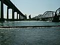
The Sault Ste. Marie International Bridge crossing the river at the Canada–United States border
|
|

|
|
| Other name(s) | Rivière Sainte-Marie |
| Countries | |
| Province/State | |
| Cities | Canada:
United States: |
| Physical characteristics | |
| Main source | Whitefish Bay (Lake Superior) 600 ft (180 m) 46°30′02″N 84°36′14″W / 46.50056°N 84.60389°W |
| River mouth | North Channel (Lake Huron) 577 ft (176 m) 46°03′20″N 83°54′34″W / 46.05556°N 83.90944°W |
| Length | 74.5 mi (119.9 km) |
The St. Marys River is a very important river that connects two of the Great Lakes: Lake Superior and Lake Huron. It flows for about 74.5 miles (120 kilometers) from Whitefish Bay in Lake Superior southeast into Lake Huron. Along its entire path, the St. Marys River forms the border between the United States (specifically Michigan) and Canada (specifically Ontario).
The river is famous for its "rapids," which are fast-flowing, shallow parts of the river. To help large ships get around these rapids, people built special waterways called "locks." These locks, known as the Soo Locks, allow huge cargo ships to travel between the lakes. The cities of Sault Ste. Marie, Ontario in Canada and Sault Ste. Marie, Michigan in the U.S. are located on opposite sides of the river and are connected by a large bridge.
Many smaller rivers flow into the St. Marys River. On the Canadian side, these include the Garden River and the Bar River. On the American side, you'll find rivers like the Gogomain River and the Munuscong River.
Contents
History of the St. Marys River

Long before Europeans arrived, the Ojibwe (also known as Chippewa) Native American people lived along the St. Marys River. They used the river for fishing and trading. They had a special path, called a portage, to carry their canoes and goods around the fast-moving rapids. They called the rapids Baawitigong, which means "at the cascading rapids."
Early European Explorers
Around 1621, a French explorer named Étienne Brûlé was likely the first European to travel up the rapids. Later, in 1641, two Jesuit priests, Isaac Jogues and Charles Raymbault, visited the area. They found many Ojibwe people there and named the place "Sault Ste. Marie." The word Sault comes from an old French word meaning "jump," which refers to how the water "jumps" over the rapids.
Forts and Borders
In 1796, Fort St. Joseph was built on the Canadian side of the river. This fort helped protect a trading post and made sure the British kept control of the area. It played a role in the War of 1812.
Building the Locks
Because the rapids made it hard for ships to pass, people decided to build locks. A lock is like a water elevator that raises or lowers boats between different water levels.
The first modern lock, called the "American Lock," was finished in May 1855. Today, there are four locks on the American side, but usually only two are used regularly. These Soo Locks became a key part of the Great Lakes Waterway system in 1959, allowing large ships to travel easily between the lakes.
A separate Canadian Lock was built in 1895. Today, this Canadian Lock is mainly used by smaller recreational boats and is a special National Historic Site of Canada.
The River During World War II
During World War II, the Soo Locks and the St. Marys River were extremely important. In 1939, about 90 percent of the iron ore used in the United States for making steel and weapons passed through this waterway. Because it was so vital for war production, both U.S. and Canadian forces heavily guarded the river and the locks. Thousands of soldiers were stationed there to protect against any possible attacks.
Islands in the River
The St. Marys River is home to several islands. Some of the larger ones include:
- Drummond Island (in Michigan)
- Neebish Island (in Michigan)
- St. Joseph Island (in Ontario)
- Squirrel Island (in Ontario, part of the Garden River First Nation)
- Sugar Island (in Michigan)
- Whitefish Island (in Ontario, part of the Batchewana First Nation)
- Lime Island (in Michigan)
Structures on the St. Marys River
Bridges Connecting Countries

Two main bridges cross the St. Marys River, connecting Canada and the United States:
- The Sault Ste. Marie International Bridge carries cars and trucks. It's a steel arch bridge.
- The Sault Ste. Marie International Railroad Bridge, located just west of the road bridge, carries trains.
Power Plants Using River Power
The St. Marys River's flowing water is used to create electricity at several power plants:
- The Edison Sault Electric Hydroelectric Plant is one of the longest hydroelectric (water-powered) plants in the world. It was finished in 1902 and can generate a lot of electricity.
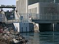
- The United States Army Corps of Engineers also runs a hydroelectric plant north of the American locks.
- The Francis H. Clergue Generating Station, owned by Brookfield Renewable Energy, Inc., is another hydroelectric plant near the Canadian lock. It was completed in 1981.
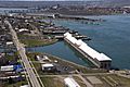
The Edison Sault Power Canal
The Edison Sault Power Canal is a man-made channel that helps power the Saint Marys Falls Hydropower Plant. This canal, which is about 2.25 miles (3.6 kilometers) long, was started in 1898 and finished in 1902. It carries water from Lake Superior to the power plant, making the downtown area of Sault Ste. Marie, Michigan, into an island.
Important Locks for Ships
The American Soo Locks are the main way large ships travel around the St. Marys Rapids. However, the Canadian Sault Ste. Marie Canal is still used by smaller boats for recreation and tours.
-
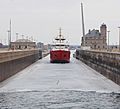
CCGS Samuel Risley breaking ice in the Poe Lock to start the shipping season.
-
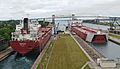
The Edgar B. Speer (downstream) and the Richelieu (upstream) sharing the Soo Locks.
-
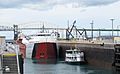
The tour boat Hiawatha and the laker Cason J. Callaway in the Poe Lock.
-
A view of the Sault Ste. Marie Canal.
.jpg)
.jpg)
.jpg)

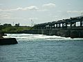
Controlling Water Flow
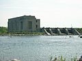
To manage the amount of water flowing out of Lake Superior, there are "compensating works" at the mouth of the rapids. These are like large gates that can be opened or closed to control the water level. There are 16 gates in total, split between the American and Canadian sides of the river. They were built between 1901 and 1921. The amount of water flow is carefully managed by the International Joint Commission.
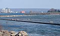
A concrete wall, called a berm, was also built along the north side of the rapids. This was done to help protect places where fish lay their eggs (called spawning habitat). This was needed because the hydroelectric dams increased the water outflow, which could affect the fish.
Pollution Concerns

The St. Marys River is listed as a "Great Lakes Area of Concern." This means that there are pollution issues in the river that need to be addressed. Both the United States and Canada are working together to improve the water quality as part of the Great Lakes Water Quality Agreement.
Images for kids
-
Saint Marys Falls Hydropower Plant at the mouth of the Edison Sault Power Canal
-
US Army Corps of Engineers hydroelectric plant seen from across the St. Marys Rapids
-
Francis H. Clergue Generating Station
-
Remedial concrete berm along the St. Marys Rapids, an effort to improve fish spawning habitat
-
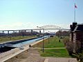
International Bridge (left) and rail bridge (right) with the remedial berm in the foreground
-
Lake Superior compensating works with a high rate of water flow (equivalent of 6 gates fully open)


See also
 In Spanish: Río St. Marys para niños
