Stanton County, Kansas facts for kids
Quick facts for kids
Stanton County
|
|
|---|---|

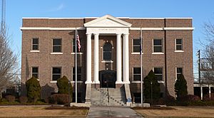
Stanton County Courthouse in Johnson City (2010)
|
|

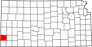
Location within the U.S. state of Kansas
|
|
 Kansas's location within the U.S. |
|
| Country | |
| State | |
| Founded | 1887 |
| Named for | Edwin Stanton |
| Seat | Johnson City |
| Largest city | Johnson City |
| Area | |
| • Total | 680 sq mi (1,800 km2) |
| • Land | 680 sq mi (1,800 km2) |
| • Water | 0.07 sq mi (0.2 km2) 0.01% |
| Population
(2020)
|
|
| • Total | 2,084 |
| • Estimate
(2021)
|
2,044 |
| • Density | 3.1/sq mi (1.2/km2) |
| Time zone | UTC−6 (Central) |
| • Summer (DST) | UTC−5 (CDT) |
| Congressional district | 1st |
Stanton County is a special area in Kansas, a state in the United States. It's like a local government area. The main town and place where the county government works is called Johnson City. In 2020, about 2,084 people lived here. The county got its name from Edwin Stanton, who was an important government official during the American Civil War. He was the U.S. Secretary of War.
Contents
History of Stanton County
For thousands of years, the wide-open Great Plains of North America were home to Native American groups. These groups often moved around, following animals and seasons.
In 1854, the area became known as the Kansas Territory. Later, in 1861, Kansas officially joined the United States as the 34th U.S. state.
Stanton County was officially created in 1887. It was named after Edwin Stanton, a key figure in American history.
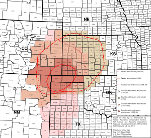
During the 1930s, the county faced a very tough time. It was part of the Dust Bowl, a period when severe dust storms hit the central United States. This natural disaster made the economic problems of the Great Depression even worse for the people living there.
Geography and Location
Stanton County covers a total area of about 680 square miles (1,761 square kilometers). Almost all of this area is land. Only a tiny part is water.
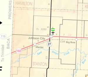
Main Roads in Stanton County
These are the most important roads that help people travel through Stanton County:
 U.S. Highway 160
 Kansas Highway 27
Neighboring Counties and States
Stanton County shares its borders with several other counties and even another state:
- Hamilton County (to the north)
- Grant County (to the east)
- Stevens County (to the southeast)
- Morton County (to the south)
- Baca County, Colorado (to the west)
- Prowers County, Colorado (to the northwest)
People and Population
| Historical population | |||
|---|---|---|---|
| Census | Pop. | %± | |
| 1880 | 5 | — | |
| 1890 | 1,031 | 20,520.0% | |
| 1900 | 327 | −68.3% | |
| 1910 | 1,034 | 216.2% | |
| 1920 | 908 | −12.2% | |
| 1930 | 2,152 | 137.0% | |
| 1940 | 1,443 | −32.9% | |
| 1950 | 2,263 | 56.8% | |
| 1960 | 2,108 | −6.8% | |
| 1970 | 2,287 | 8.5% | |
| 1980 | 2,339 | 2.3% | |
| 1990 | 2,333 | −0.3% | |
| 2000 | 2,406 | 3.1% | |
| 2010 | 2,235 | −7.1% | |
| 2020 | 2,084 | −6.8% | |
| 2023 (est.) | 1,901 | −14.9% | |
| U.S. Decennial Census 1790-1960 1900-1990 1990-2000 2010-2020 |
|||
In 2000, there were 2,406 people living in Stanton County. These people lived in 858 households, and 638 of these were families. The county had about 4 people per square mile.
Most people in the county (about 84%) were White. About 12.5% were from other races, and a small number were Black, Native American, or Asian. About 23.7% of the people were Hispanic or Latino.
About 40% of households had children under 18 living with them. Most households (63.5%) were married couples. The average household had about 2.74 people.
The population was spread out by age. About 30.8% were under 18 years old. About 13% were 65 years or older. The average age in the county was 34 years.
The median income for a household in the county was $40,172 per year. For families, it was $46,300. About 14.9% of the population lived below the poverty line. This included 16.8% of those under 18.
Education in Stanton County
Stanton County has its own school district that serves the students in the area.
School Districts
- Stanton County USD 452
Communities in Stanton County
Stanton County has several towns and communities. Some are cities, and others are smaller, unincorporated communities.
Cities
- Johnson City (This is the county seat, where the main county offices are.)
- Manter
Unincorporated Communities
These are smaller communities that are not officially organized as cities:
- Big Bow
- Julian
- Saunders
Townships

Stanton County is divided into three main areas called townships. The populations of the cities are included in their township's total.
| Township | Population center |
Population | Population density /km2 (/sq mi) |
Land area km2 (sq mi) |
Geographic coordinates |
|---|---|---|---|---|---|
| Big Bow | 338 | 1 (2) | 558 (216) | 37°33′18″N 101°36′30″W / 37.55500°N 101.60833°W | |
| Manter | 312 | 0 (1) | 647 (250) | 37°33′15″N 101°56′7″W / 37.55417°N 101.93528°W | |
| Stanton | Johnson City | 1,756 | 3 (8) | 556 (215) | 37°33′42″N 101°45′31″W / 37.56167°N 101.75861°W |
See also
 In Spanish: Condado de Stanton (Kansas) para niños


