Starke County, Indiana facts for kids
Quick facts for kids
Starke County
|
||
|---|---|---|

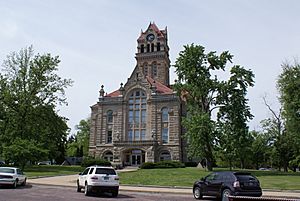
Starke County courthouse in Knox
|
||
|
||

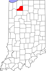
Location within the U.S. state of Indiana
|
||
 Indiana's location within the U.S. |
||
| Country | ||
| State | ||
| Founded | February 7, 1835 (authorized) 1850 (organized) |
|
| Named for | General John Stark | |
| Seat | Knox | |
| Largest city | Knox | |
| Area | ||
| • Total | 312.21 sq mi (808.6 km2) | |
| • Land | 309.13 sq mi (800.6 km2) | |
| • Water | 3.07 sq mi (8.0 km2) 0.98%% | |
| Population
(2020)
|
||
| • Total | 23,371 | |
| • Estimate
(2023)
|
23,206 |
|
| • Density | 74.8567/sq mi (28.9023/km2) | |
| Time zone | UTC−6 (Central) | |
| • Summer (DST) | UTC−5 (CDT) | |
| Congressional district | 2nd | |
| Indiana county number 75 | ||
Starke County is a county located in the state of Indiana in the United States. In 2020, about 23,371 people lived there. The main city and county seat is Knox.
Contents
History of Starke County
The state of Indiana decided to create 13 new counties in northeast Indiana on February 7, 1835. Starke County was one of them. The county government officially started working in 1850. The county was named after General John Stark. He was a hero in the American Revolutionary War. He led troops from New Hampshire at the Battle of Bunker Hill in 1775. He also won against the British at the Battle of Bennington in 1777.
Before settlers from Europe arrived, the land that is now Starke County was home to the Potawatami Indian nation. Sadly, in 1838, the United States government forced these groups to move far away to Kansas. Many people died during this difficult journey, which is now known as the Potawatomi Trail of Death.
When Starke County was first created, it included some areas that are now part of LaPorte County. These areas were Cass, Dewey, Hanna, and Prairie townships. People living in these northern areas found it hard to travel to the county center in Knox. They had to go a long way east to cross the Kankakee River. Because they felt cut off, they asked to become part of LaPorte County. This change happened on January 28, 1842.
Why the Name "Starke"?
The county was named after General John Stark, and it was first spelled "Stark" on maps. But later, an "e" was added to the name, making it "Starke." No one knows for sure why this happened. There are a few ideas:
- One idea is that an early writer had a fancy way of writing the letter "k," which looked like "ke."
- Another idea is that General Stark himself might have used a similar flourish in his signature.
- A third idea is that an official in Indianapolis made a mistake around 1860, and the new spelling stuck.
Geography and Nature
Starke County has gentle, rolling hills covered with plants and trees. The highest points in the county are about 780 feet (238 meters) above sea level. These high spots are near Bass Lake.
In 2010, Starke County had a total area of about 312.21 square miles (808.6 square kilometers). About 3.07 square miles (7.95 square kilometers) of this area is water. The Kankakee River forms the northwestern border of the county. The Yellow River, which flows into the Kankakee, runs through the middle of the county, passing by Knox.
From 2014 to 2024, the city of Knox was considered the geographic center of the Big Ten Conference. This was based on where different college basketball championships were held.
Main Roads
Neighboring Counties
- LaPorte County - north
- St. Joseph County - northeast
- Marshall County - east
- Fulton County - southeast
- Pulaski County - south
- Jasper County - west
- Porter County - northwest
Cities, Towns, and Communities
Here are the main cities, towns, and other communities in Starke County, along with how many people lived there in 2010:
Cities and Towns
- Hamlet – 800 people
- Knox – 3,704 people
- North Judson – 1,772 people
Census-Designated Places
These are areas that are like towns but are not officially incorporated as cities or towns.
- Bass Lake – 1,249 people
- Koontz Lake – 1,554 people
- San Pierre – 156 people
Unincorporated Communities
These are smaller communities that are not officially part of a city or town.
- Aldine
- Bass Station
- Brems
- English Lake
- Grovertown
- Indian Hill
- Lena Park
- Lomax
- Oak Grove
- Ober
- Ora
- Toto
- Winona
Townships
Starke County is divided into nine townships. Here are their populations from 2010:
- California – 2,011 people
- Center – 6,229 people
- Davis – 1,043 people
- Jackson – 549 people
- North Bend – 1,394 people
- Oregon – 3,367 people
- Railroad – 1,226 people
- Washington – 3,003 people
- Wayne – 4,541 people
Education and Healthcare
Schools
Public schools in Starke County are managed by four different school districts:
- Culver Community Schools
- Knox Community School Corporation
- North Judson-San Pierre Schools
- Oregon-Davis School Corporation
Hospitals
- Northwest Health Starke
Climate and Weather
| Weather chart for Knox, Indiana | |||||||||||||||||||||||||||||||||||||||||||||||
|---|---|---|---|---|---|---|---|---|---|---|---|---|---|---|---|---|---|---|---|---|---|---|---|---|---|---|---|---|---|---|---|---|---|---|---|---|---|---|---|---|---|---|---|---|---|---|---|
| J | F | M | A | M | J | J | A | S | O | N | D | ||||||||||||||||||||||||||||||||||||
|
1.9
31
14
|
1.7
36
18
|
2.7
47
28
|
3.5
60
38
|
3.8
72
50
|
4.1
80
59
|
3.9
84
63
|
3.9
82
61
|
3.3
75
53
|
2.9
64
42
|
3.1
49
31
|
2.6
36
20
|
||||||||||||||||||||||||||||||||||||
| temperatures in °F precipitation totals in inches source: The Weather Channel |
|||||||||||||||||||||||||||||||||||||||||||||||
|
Metric conversion
|
|||||||||||||||||||||||||||||||||||||||||||||||
In Knox, the average temperatures usually range from a low of 14°F (-10°C) in January to a high of 84°F (29°C) in July. However, the coldest temperature ever recorded was -29°F (-34°C) in January 1985. The hottest was 102°F (39°C) in June 1988. The amount of rain and snow changes throughout the year, with June usually being the wettest month.
Population Information
| Historical population | |||
|---|---|---|---|
| Census | Pop. | %± | |
| 1840 | 149 | — | |
| 1850 | 557 | 273.8% | |
| 1860 | 2,195 | 294.1% | |
| 1870 | 3,888 | 77.1% | |
| 1880 | 5,105 | 31.3% | |
| 1890 | 7,339 | 43.8% | |
| 1900 | 10,431 | 42.1% | |
| 1910 | 10,567 | 1.3% | |
| 1920 | 10,278 | −2.7% | |
| 1930 | 10,620 | 3.3% | |
| 1940 | 12,258 | 15.4% | |
| 1950 | 15,282 | 24.7% | |
| 1960 | 17,911 | 17.2% | |
| 1970 | 19,280 | 7.6% | |
| 1980 | 21,997 | 14.1% | |
| 1990 | 22,747 | 3.4% | |
| 2000 | 23,556 | 3.6% | |
| 2010 | 23,363 | −0.8% | |
| 2020 | 23,371 | 0.0% | |
| 2023 (est.) | 23,206 | −0.7% | |
| US Decennial Census 1790-1960 1900-1990 1990-2000 2010-2021 |
|||
In 2010, there were 23,363 people living in Starke County. There were 9,038 households and 6,484 families. The county had about 75.6 people per square mile (29.2 people per square kilometer). Most of the people living in the county (97.1%) were White. About 3.3% of the population was of Hispanic or Latino origin. Many people had German (27.2%), Irish (16.3%), or English (8.9%) backgrounds.
About 32.7% of households had children under 18 living with them. The average household had 2.58 people. The average age of people in the county was 40.4 years old.
See also
 In Spanish: Condado de Starke para niños
 | John T. Biggers |
 | Thomas Blackshear |
 | Mark Bradford |
 | Beverly Buchanan |


