
Subantarctic facts for kids
The Subantarctic is a special area in the southern part of the world. It's just north of the very cold Antarctic region. Imagine lines around the Earth; this area is mostly between 46 and 60 degrees south of the Equator (the imaginary line around the middle of the Earth).
This region includes many islands in the southern parts of the Atlantic, Indian, and Pacific Oceans. These islands are often found north of a special ocean boundary called the Antarctic Convergence.
Subantarctic glaciers are ice rivers found on these islands. Any glaciers on the main continent of Antarctica itself are called Antarctic glaciers.
What is the Subantarctic Region?
The Subantarctic region is made up of two main areas and three important ocean boundaries, like invisible lines in the water.
Ocean Boundaries and Zones
- The northern edge of the Subantarctic region is called the Subtropical Front (STF). Think of it as where warmer waters from the tropics start to meet cooler waters.
- South of the STF is a large ocean area known as the Subantarctic Zone (SAZ).
- Further south from the SAZ is another important boundary, the Subantarctic Front (SAF).
- Even further south from the SAF is a marine area called the Polar Frontal Zone (PFZ).
- The SAZ and the PFZ together make up the entire Subantarctic region.
- The southernmost boundary of the PFZ (and the whole Subantarctic region) is the Antarctic Convergence. This is a very important line where cold waters from the Antarctic sink and meet warmer waters, creating a unique environment. It's about 200 kilometers south of the Antarctic Polar Front (APF).
Images for kids
-
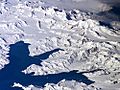
Satellite image of central South Georgia: Harker Glacier, Cumberland Bay, Thatcher Peninsula, Allardyce Range, Mount Paget.
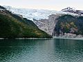
-
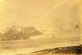
Neumayer Glacier, Cumberland West Bay, South Georgia, around 1882-1883.
-
Neumayer Glacier, Cumberland West Bay, South Georgia, around 1882-1883.
-
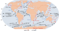
Diagram of the major ocean currents, showing the Antarctic Circumpolar Current (ACC). This current strongly affects global climate.
-
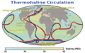
Global thermohaline circulation strongly affects regional and global climate. Blue paths show deep-water currents, while red paths show surface currents.
-
Trees growing along the north shore of the Beagle Channel, at 55°S latitude.
-
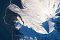
Satellite image of the southern tip of Heard Island. Cape Arkona is on the left, with Lied Glacier just above and Gotley Glacier just below. Big Ben Volcano and Mawson Peak are at the lower right.
-
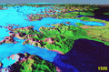
The retreat of San Rafael Glacier from 1990 to 2000. San Quintín Glacier is in the background.


See also
 In Spanish: Subantártico para niños
