Sugar Hill, Georgia facts for kids
Quick facts for kids
Sugar Hill, Georgia
|
|||||
|---|---|---|---|---|---|

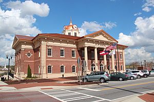
Sugar Hill City Hall
|
|||||
|
|||||
| Country | United States | ||||
| State | Georgia | ||||
| County | Gwinnett | ||||
| Area | |||||
| • Total | 11.16 sq mi (28.91 km2) | ||||
| • Land | 11.13 sq mi (28.82 km2) | ||||
| • Water | 0.04 sq mi (0.10 km2) | ||||
| Elevation | 1,086 ft (331 m) | ||||
| Population
(2020)
|
|||||
| • Total | 25,076 | ||||
| • Density | 2,253.82/sq mi (870.22/km2) | ||||
| Time zone | UTC-5 (Eastern (EST)) | ||||
| • Summer (DST) | UTC-4 (EDT) | ||||
| ZIP code |
30518
|
||||
| Area code(s) | 770, 678 | ||||
| FIPS code | 13-74180 | ||||
| GNIS feature ID | 2405538 | ||||
Sugar Hill is a city located in the northern part of Gwinnett County, in the state of Georgia, United States. It is part of the larger Metro Atlanta area. In 2020, about 25,076 people lived there, making it the fourth-largest city in Gwinnett County. Sugar Hill is also close to Lake Lanier and the lower parts of the North Georgia mountains.
Contents
History of Sugar Hill
Sugar Hill became an official town on March 24, 1939, when the Georgia state assembly approved its charter. It was known as the Town of Sugar Hill. Later, in 1975, its name was changed to the City of Sugar Hill.
Before it became a city, the area was a path connecting the railroad in Buford to the city of Cumming. A local story says the town got its name after a large amount of sugar spilled there. People then started calling it "the hill where the sugar spilled" or "the sugar hill."
In 2001, the cost of natural gas in Sugar Hill became much higher than in nearby areas. This made many residents unhappy. They formed a group called "The Committee to Dissolve Sugar Hill." Over 1,600 people signed a petition asking for a vote to get rid of the city's gas company and even the city itself. A state senator tried to pass a bill for this vote, but it did not succeed. The city council then lowered the gas prices to match those in the surrounding areas.
Geography of Sugar Hill
| Weather chart for Sugar Hill, Georgia | |||||||||||||||||||||||||||||||||||||||||||||||
|---|---|---|---|---|---|---|---|---|---|---|---|---|---|---|---|---|---|---|---|---|---|---|---|---|---|---|---|---|---|---|---|---|---|---|---|---|---|---|---|---|---|---|---|---|---|---|---|
| J | F | M | A | M | J | J | A | S | O | N | D | ||||||||||||||||||||||||||||||||||||
|
5.2
50
32
|
5.3
54
34
|
5.2
63
41
|
3.7
71
48
|
3.8
77
56
|
4.1
84
65
|
4.2
87
69
|
4.4
86
68
|
4.6
80
61
|
3.9
71
51
|
4.3
62
42
|
4.7
52
34
|
||||||||||||||||||||||||||||||||||||
| temperatures in °F precipitation totals in inches |
|||||||||||||||||||||||||||||||||||||||||||||||
|
Metric conversion
|
|||||||||||||||||||||||||||||||||||||||||||||||
Sugar Hill is in the northern part of Gwinnett County, Georgia. It shares borders with Buford to the northeast and Suwanee to the southwest.
Georgia State Route 20 is the main road that goes through the middle of Sugar Hill. This road goes northwest about 11 miles to Cumming. It also goes south about 12 miles to Lawrenceville, which is the county seat of Gwinnett County.
U.S. Route 23 runs along the southern edge of Sugar Hill. It leads southwest about 5 miles to Suwanee and 10 miles to Duluth. US 23 then turns southeast near the border of Sugar Hill and Buford. It runs for about 1 mile with SR 20 to Interstate 985. From there, I-985 goes northeast about 19 miles to Gainesville and southwest about 36 miles to downtown Atlanta.
In 2010, the city of Sugar Hill had a total land area of about 27.5 square kilometers (10.6 square miles). Only a small part, about 0.1 square kilometers (0.04 square miles), was water. The city's elevation is about 1,149 feet (350 meters) above sea level.
Sugar Hill's Climate
Sugar Hill has a humid subtropical climate. This means it has four seasons. Summers are hot and humid, while winters are cool.
July is usually the warmest month, with an average high temperature of about 87°F (31°C). January is the coldest month, with an average high of about 50°F (10°C). The highest temperature ever recorded was 107°F (42°C) in 1952. The lowest was -8°F (-22°C) in 1985.
Sugar Hill gets a good amount of rain throughout the year. February typically has the most rain, with about 5.3 inches (130 mm). April is usually the driest month, with about 3.7 inches (94 mm) of rain.
Population and People
| Historical population | |||
|---|---|---|---|
| Census | Pop. | %± | |
| 1940 | 599 | — | |
| 1950 | 783 | 30.7% | |
| 1960 | 1,175 | 50.1% | |
| 1970 | 1,745 | 48.5% | |
| 1980 | 2,473 | 41.7% | |
| 1990 | 4,557 | 84.3% | |
| 2000 | 11,399 | 150.1% | |
| 2010 | 18,522 | 62.5% | |
| 2020 | 25,076 | 35.4% | |
| U.S. Decennial Census | |||
Sugar Hill is the fourth-largest city in Gwinnett County based on its population. It used to be the third-largest until Peachtree Corners became a city in 2012. After the 2000 census, Sugar Hill was one of the fastest-growing cities in the nation. Its population grew by 35.4% between 2010 and 2020.
In the 2020 census, Sugar Hill had 25,076 people living in 8,271 households. The city had about 2,253.8 people per square mile (870.2 people per square kilometer).
The people living in Sugar Hill come from many different backgrounds:
- 62.7% were White.
- 12.4% were Black or African American.
- 0.7% were Native American.
- 11.4% were Asian.
- 6.9% were from two or more races.
- 19.9% of the population was Hispanic or Latino (of any race).
In 2020, about 27.4% of the people in Sugar Hill were under 18 years old. The average income for a household in the city was $89,583. For families, the average income was $75,473. The average income for each person in the city was $35,990. About 8.2% of the population lived below the poverty line. This included 17.4% of those under 18 and 4.0% of those aged 65 or older.
Economy and Business
Like the rest of Gwinnett County, Sugar Hill has a sales tax of 6%. This includes a 4% state sales tax and a 2% local tax.
In 2011, a new law allowed local communities in Georgia to vote on whether to permit alcohol sales on Sundays. Before this, Sunday sales had been banned since the 1800s. Supporters believed allowing Sunday sales would help the local economy.
On November 8, 2011, Sugar Hill was one of many cities that held a vote on this issue. The Sugar Hill city council decided to let its residents vote. On November 15, 2011, Sugar Hill voted to allow Sunday sales of alcohol. By 2012, all other areas in Gwinnett County also voted to allow Sunday sales.
Education in Sugar Hill
The Gwinnett County Public Schools system serves students from kindergarten through 12th grade in Sugar Hill.
The public schools that serve most Sugar Hill residents include:
- Sugar Hill Elementary School
- White Oak Elementary School
- Sycamore Elementary School
- Lanier Middle School
- Lanier High School
Some parts of Sugar Hill are also in the North Gwinnett school district. These areas are served by:
- Riverside Elementary School
- North Gwinnett Middle School
- North Gwinnett High School
The Gwinnett County Public Library also has a branch called the Buford-Sugar Hill Branch, which is located in Buford.
Media and News
As part of the Metro Atlanta area, Sugar Hill receives television broadcasts from major networks. These include WXIA-TV (NBC), WANF (CBS), WSB-TV (ABC), and WAGA-TV (Fox). WGTV is the local station for the statewide Georgia Public Television network and is a PBS member station.
The main newspaper for Sugar Hill is the Gwinnett Daily Post. This newspaper is widely read in Sugar Hill and throughout Gwinnett County. The Atlanta Journal-Constitution is also available in Sugar Hill. In the past, a weekly newspaper called the Gwinnett Herald served Sugar Hill from 1871 to 1885.
Transportation and Utilities
Roads and Paths
The main road in Sugar Hill is Georgia State Route 20. It runs generally northwest to southeast through the city. It goes southeast into Buford and northwest into Forsyth County. The closest major highways are I-985 and I-85, which can be reached from State Route 20 in Buford.
For walking and biking, Sugar Hill is developing new paths:
- Sugar Hill Greenway (currently being built)
- Western Gwinnett Bikeway (currently being built)
City Utilities
The city of Sugar Hill manages its own gas department, called the Sugar Hill Gas Department. This department provides natural gas to the city's residents. The city is also a member of the Municipal Gas Authority of Georgia.
Notable People from Sugar Hill
Many interesting people have connections to Sugar Hill:
- Derrick Brown, an NFL football player
- Zach Calzada, a college football player
- Kurt Johnson, a former professional drag racer in the NHRA
- Warren Johnson, another former professional drag racer in the NHRA
- Daryl Mitchell, a television and movie actor
See also
 In Spanish: Sugar Hill (Georgia) para niños
 | Sharif Bey |
 | Hale Woodruff |
 | Richmond Barthé |
 | Purvis Young |


