Tallapoosa County, Alabama facts for kids
Quick facts for kids
Tallapoosa County
|
||
|---|---|---|

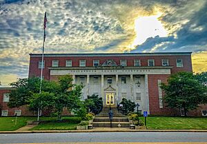
Tallapoosa County Courthouse in Dadeville
|
||
|
||

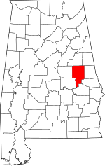
Location within the U.S. state of Alabama
|
||
 Alabama's location within the U.S. |
||
| Country | ||
| State | ||
| Founded | December 18, 1832 | |
| Named for | Tallapoosa River | |
| Seat | Dadeville | |
| Largest city | Alexander City | |
| Area | ||
| • Total | 766 sq mi (1,980 km2) | |
| • Land | 717 sq mi (1,860 km2) | |
| • Water | 50 sq mi (100 km2) 6.5% | |
| Population
(2020)
|
||
| • Total | 41,311 | |
| • Estimate
(2023)
|
40,677 |
|
| • Density | 53.93/sq mi (20.823/km2) | |
| Time zone | UTC−6 (Central) | |
| • Summer (DST) | UTC−5 (CDT) | |
| Congressional district | 3rd | |
|
||
Tallapoosa County is a county located in the middle-eastern part of the U.S. state of Alabama. In 2020, about 41,311 people lived there. The main town, called the county seat, is Dadeville. The biggest city in the county is Alexander City.
Contents
What's in a Name? The Meaning of Tallapoosa
The name Tallapoosa comes from the Creek people. Many Creek villages were once located along the lower parts of the Tallapoosa River. The county is named after this river.
The word "Tallapoosa" might mean "pulverized rock" in the Choctaw language. It could also mean "grandmother town" in the Muscogee language. The Tallapoosa branch of the Muscogee tribe is thought to be one of the oldest groups in the southeastern United States. The river was a very important place for the Creek people before the early 1800s.
A Look Back: Tallapoosa County's History
Tallapoosa County was created in 1832. This happened after the Creek Indians gave up their lands in a special agreement called the Treaty of Cusseta. The first county seat was a Creek town named Okfuskee.
After the Creek people were forced to move in 1836 and 1837, many people rushed to the area looking for gold. This brought a lot of new settlers hoping to find wealth.
The county was officially started on December 18, 1832. Later, on February 15, 1866, a part of Tallapoosa County was used to create Elmore County.
A very important battle, the Battle of Horseshoe Bend, happened in this area in 1814. This battle was a major event that effectively ended the Creek War.
Where is Tallapoosa County? Geography and Roads
Tallapoosa County covers about 766 square miles. Most of this (717 square miles) is land, and about 50 square miles (6.5%) is water. The county is located in a hilly area of Alabama called the Piedmont region.
The Tallapoosa River flows through the county.
Main Roads You Can Drive On
 U.S. Highway 280
 State Route 14
 State Route 22
 State Route 49
 State Route 50
 State Route 63
 State Route 120
 State Route 128
 State Route 259
Neighboring Counties
- Clay County (north)
- Randolph County (northeast)
- Chambers County (east)
- Lee County (southeast)
- Macon County (south)
- Elmore County (southwest)
- Coosa County (west)
Special Protected Area
Who Lives Here? Population and People
| Historical population | |||
|---|---|---|---|
| Census | Pop. | %± | |
| 1840 | 6,444 | — | |
| 1850 | 15,584 | 141.8% | |
| 1860 | 23,827 | 52.9% | |
| 1870 | 16,963 | −28.8% | |
| 1880 | 23,401 | 38.0% | |
| 1890 | 25,460 | 8.8% | |
| 1900 | 29,675 | 16.6% | |
| 1910 | 31,034 | 4.6% | |
| 1920 | 29,744 | −4.2% | |
| 1930 | 31,188 | 4.9% | |
| 1940 | 35,270 | 13.1% | |
| 1950 | 35,074 | −0.6% | |
| 1960 | 35,007 | −0.2% | |
| 1970 | 33,840 | −3.3% | |
| 1980 | 38,766 | 14.6% | |
| 1990 | 38,826 | 0.2% | |
| 2000 | 41,475 | 6.8% | |
| 2010 | 41,616 | 0.3% | |
| 2020 | 41,311 | −0.7% | |
| 2023 (est.) | 40,677 | −2.3% | |
| U.S. Decennial Census 1790–1960 1900–1990 1990–2000 2010–2020 |
|||
Population in 2020
In 2020, the census counted 41,311 people living in Tallapoosa County. There were 16,205 households and 11,183 families.
The table below shows the different groups of people living in the county. It separates people by race and ethnicity. Hispanic/Latino is a separate group, and people from any race can be Hispanic/Latino.
| Race / Ethnicity (NH = Non-Hispanic) | Pop 2000 | Pop 2010 | Pop 2020 | % 2000 | % 2010 | % 2020 |
|---|---|---|---|---|---|---|
| White alone (NH) | 30,342 | 28,838 | 28,252 | 73.16% | 69.30% | 68.39% |
| Black or African American alone (NH) | 10,488 | 11,050 | 10,366 | 25.29% | 26.55% | 25.09% |
| Native American or Alaska Native alone (NH) | 107 | 119 | 84 | 0.26% | 0.29% | 0.20% |
| Asian alone (NH) | 74 | 197 | 222 | 0.18% | 0.47% | 0.54% |
| Pacific Islander alone (NH) | 3 | 2 | 0 | 0.01% | 0.00% | 0.00% |
| Other race alone (NH) | 5 | 22 | 91 | 0.01% | 0.05% | 0.22% |
| Mixed race or Multiracial (NH) | 214 | 346 | 1,152 | 0.52% | 0.83% | 2.79% |
| Hispanic or Latino (any race) | 242 | 1,042 | 1,144 | 0.58% | 2.50% | 2.77% |
| Total | 41,475 | 41,616 | 41,311 | 100.00% | 100.00% | 100.00% |
More About the People (2010 Census)
In 2010, there were 41,616 people living in the county. About 58 people lived in each square mile. There were 16,985 households. A household is a group of people living together.
About 25.6% of households had children under 18. Nearly half (48.4%) were married couples. About 15.9% were led by a female without a husband.
The average household had 2.42 people. The average family had 2.91 people.
The age of people in the county varied. About 22.2% were under 18 years old. About 17.3% were 65 or older. The average age was 42.4 years. For every 100 females, there were about 94 males.
The average income for a household was $36,904. For families, it was $47,918. About 17.5% of the people lived below the poverty line. This included 27.8% of those under 18.
Towns and Communities
Cities
- Alexander City
- Dadeville (county seat)
- Tallassee (partly in Elmore County)
Towns
Special Places (Census-designated)
Small, Unincorporated Communities
- Andrew Jackson
- Bulgers
- Cherokee Bluffs
- Church Hill
- Dudleyville
- Fosheeton
- Frog Eye
Learning in Tallapoosa County: Schools
The county has several school districts:
- Alexander City City School District
- Tallapoosa County School District
- Tallassee City School District
See also
 In Spanish: Condado de Tallapoosa para niños
 | Delilah Pierce |
 | Gordon Parks |
 | Augusta Savage |
 | Charles Ethan Porter |


