
Tamsui District facts for kids
Quick facts for kids
Tamsui
淡水區
Tansui, Danshuei, Tanshui, Danshui
|
|
|---|---|
|
District
|
|
| Tamsui District | |

Skyline of Tamsui District in 2013
|
|

Tamsui District in New Taipei City
|
|
| Country | |
| Special municipality | New Taipei City, Taiwan |
| Area | |
| • Total | 70.65 km2 (27.28 sq mi) |
| Population
(February 2023)
|
|
| • Total | 189,271 |
| • Density | 2,299/km2 (5,950/sq mi) |
| Time zone | +8 |
| Tamsui | |||||||||||||||||||||||||||||||||||
|---|---|---|---|---|---|---|---|---|---|---|---|---|---|---|---|---|---|---|---|---|---|---|---|---|---|---|---|---|---|---|---|---|---|---|---|
.jpg)
Tamsui District office
|
|||||||||||||||||||||||||||||||||||
| Chinese | 淡水 | ||||||||||||||||||||||||||||||||||
| Postal | Tamsui | ||||||||||||||||||||||||||||||||||
|
|||||||||||||||||||||||||||||||||||
| Hobe | |||||||||||||||||||||||||||||||||||
| Traditional Chinese | 滬尾 | ||||||||||||||||||||||||||||||||||
|
|||||||||||||||||||||||||||||||||||
Tamsui District is a beautiful seaside area in New Taipei, Taiwan. It gets its name from the Tamsui River, and "Tamsui" means "fresh water." This town is famous for its amazing sunsets over the Taiwan Strait. Even though it's not huge, with about 189,271 people, Tamsui plays a big part in Taiwanese culture.
Contents
About the Name
Past Names of Tamsui
Long ago, the Ketagalan aborigines lived here. They called the area Hoba, which means "stream's mouth." This name was later used in Taiwanese Hokkien as Hobe. Old English writings also called it "Hobe" or "Hobe Village."
When the Spanish arrived in the 1600s, they named the place Casidor. They called the Tamsui River Kimalon. Dutch records from that time used names like Tamsuy and Tampsui.
In the early 1900s, people spelled the name in many ways. The spelling "Tamsui" became the most common. Back then, "Tamsui" could mean the harbor, the river, or even the whole area.
Modern Names
From 1950 to 2010, Tamsui was officially "Tamsui Township." The spelling "Danshui" was once used by the Taiwan government and the Taipei Metro. This spelling comes from the Mandarin pronunciation.
However, the name "Tamsui" comes from the Taiwanese Hokkien language. In 2011, the local government asked the national government to use "Tamsui" as the official English name.
History of Tamsui

Spanish Settlement
The Spanish arrived in Tamsui in the 1600s. In 1629, they built their first big settlement here, called Santo Domingo. The Spanish wanted to protect their interests in the Philippines from the Dutch, British, and Portuguese. They also wanted to trade with China and Japan.
Dutch Control
In 1642, the Dutch took control of Taiwan and forced the Spanish out. The Spanish had already left Tamsui in 1638. The Dutch then built a new fort called Fort Anthonio. Today, this fort is known as Angmo Siaa (meaning "red-hair fortress") and is part of the Fort San Domingo museum.
The Dutch encouraged Chinese people to move to the area. They also increased the production and trade of things like sulfur and animal skins. In 1662, the Dutch left Taiwan after being defeated by Koxinga. He continued to encourage Chinese immigration.
Qing Dynasty Era

Because Tamsui was close to mainland China and had a natural harbor, it quickly became a busy fishing and trading port. In 1808, the Qing navy set up an outpost here. In 1862, the Qing government opened Tamsui for foreign trade. They exported tea, camphor, sulfur, coal, and dyes. By the mid-1800s, Tamsui was the biggest port in Taiwan. It had many foreign residents and a British consulate.

A Canadian doctor and missionary named George Leslie Mackay arrived in Tamsui in 1872. He started Taiwan's first Western-style hospitals and schools. One of these was Oxford College, which is now part of Aletheia University.
During the Sino-French War in 1884, the French navy tried to invade Taiwan. They blockaded Tamsui's harbor. The Chinese forces, with help from local aboriginals, defeated the French at the Battle of Tamsui. The French then withdrew after a long fight in Keelung.
Japanese Rule

Taiwan was given to Japan after the First Sino-Japanese War in 1895. Around this time, Tamsui's port started to become less important. This was because the Tamsui River was filling up with dirt and sand. By the 1900s, most port activities moved to Keelung. Tamsui's economy then focused more on agriculture.
However, the Japanese built new public buildings and roads. This helped Tamsui become an important local center for government and culture. From 1920, Tamsui was called Tamsui Town (淡水街).
After World War II

After World War II ended in 1945, Tamsui went back to being a small fishing town. As nearby Taipei City grew, Tamsui slowly became a popular place for tourists on Taiwan's northwest coast. In recent years, many people have moved here, making it a popular suburb of Taipei.
In 1997, the Taipei Metro's Tamsui Line was finished. This brought a huge increase in tourists. Because of this, several riverside parks were built. Open-air markets selling traditional crafts and snacks grew. A fisherman's wharf was built, and more ferries started running along the river.
Education
Tamsui is home to several important schools and universities:
- Aletheia University
- St. John's University
- Tamkang University
- Taipei University of Marine Technology
- New Taipei Municipal Tam-Shui Vocational High School
- New Taipei Municipal Zhuwei High School
- Tamshui Junior High School
Fun Places to Visit

Tamsui has many interesting places for visitors:
- Drop of Water Memorial Hall
- Former British Merchant Warehouse
- Fort San Domingo
- Hobe Fort
- Museum of Tamsui Fishiegoodies
- Tamsui Art Gallery
- Tamsui Church
- Tamsui Customs Officers' Residence
- Tamsui Customs Wharf
- Tamsui Fisherman's Wharf
- Tamsui Fuyou Temple
- Tamsui Historical Museum
- Tamsui Lover's Bridge
- Tamsui Lungshan Temple
- Tamsui Meteorological Observatory
- Tamsui Old Street (a famous street with shops and food)
- Tamsui Qingshui Temple
- Tamsui Qingshui Deity's Grand Procession (a big festival on the 6th day of the 5th lunar month)
- Tamsui Red Castle
- Teng Feng Fish Ball Museum
Getting Around Tamsui

You can easily get around Tamsui using public transport:
Taipei Metro
- Tamsui Station
- Hongshulin Station
- Zhuwei Station
Light Rail
- Danhai light rail
Sister City
Tamsui has a sister city in the United States:
 Chico, California, U.S. – since 1985
Famous People from Tamsui
- Joe Hung, who was a representative for Taiwan in Italy from 1993 to 2000.
- Tu Tsung-ming, a well-known physician.
Images for kids
-
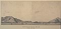
A French sketch of Tamsui in 1893
-
Tamsui Port, around 1970
-
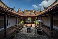
The Yinshan Temple in Tamsui, 2018
-
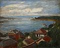
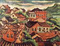
Tamsui Harbor (Li Mei-shu, 1930)
-
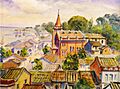
Tamsui (Tan Ting-pho, 1935)
-
Tamsui Church (Ni Chiang-huai, 1936)
-
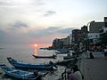
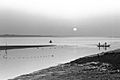
Tamsui waterfront at sunset
-
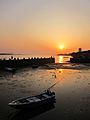
The sunset in front of the Long Pier of Tamsui


See also
 In Spanish: Tamsui para niños
