
Keelung facts for kids
Quick facts for kids
Keelung
基隆市
Kīrun, Ke-lung, Chilung
|
|||
|---|---|---|---|
|
City
|
|||
| Keelung City | |||
|
Top: Keelung's city view
Second left: Dawulun Fort Second right: Keelung at night Third left: Colorful houses at Zhengbin Fishing Port Third right: Keelung Maritime Plaza and Main Station Bottom left: Keelung Outer Harbor and Keelung Islet Bottom right: Heping Island Park |
|||
|
|||
| Nickname(s):
The Rainy Port (雨港)
|
|||

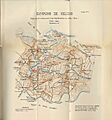
Location in Taiwan
|
|||
| Country | |||
| Province | |||
| Region | Northern Taiwan | ||
| Districts | 7 | ||
| Founded as La Santisima Trinidad | 1626 | ||
| Part of Taihoku Prefecture | 17 April 1895 | ||
| Provincial city status | 11 November 1945 | ||
| City seat | Zhongzheng District | ||
| Government | |||
| • Body |
|
||
| Area | |||
| • Total | 132.7589 km2 (51.2585 sq mi) | ||
| Area rank | 18 of 22 | ||
| Population
(October 2023)
|
|||
| • Total | 362,487 | ||
| • Rank | 16 of 22 | ||
| • Density | 2,730.416/km2 (7,071.744/sq mi) | ||
| Time zone | UTC+8 (National Standard Time) | ||
| Postal code |
200–206
|
||
| Area code(s) | (0)32 | ||
| ISO 3166 code | TW-KEE | ||
| – Bird | Eagle | ||
| – Flower | Common crepe myrtle | ||
| – Tree | Formosan Sweet-gum | ||
| English | Keelung/KLC | ||
| Chinese | 基隆/基市 | ||


.jpg)


| Keelung City | |||||||||||||||||||||||||||||||||||||
|---|---|---|---|---|---|---|---|---|---|---|---|---|---|---|---|---|---|---|---|---|---|---|---|---|---|---|---|---|---|---|---|---|---|---|---|---|---|
| Chinese name | |||||||||||||||||||||||||||||||||||||
| Chinese | 基隆市 | ||||||||||||||||||||||||||||||||||||
|
|||||||||||||||||||||||||||||||||||||
| Taiwanese Hokkien Name | |||||||||||||||||||||||||||||||||||||
| Traditional Chinese | 雞籠市 | ||||||||||||||||||||||||||||||||||||
| Simplified Chinese | 鸡笼市 | ||||||||||||||||||||||||||||||||||||
|
|||||||||||||||||||||||||||||||||||||
| Japanese name | |||||||||||||||||||||||||||||||||||||
| Kanji | 基隆市 | ||||||||||||||||||||||||||||||||||||
| Kana | キールンし | ||||||||||||||||||||||||||||||||||||
| Hiragana | きーるんし | ||||||||||||||||||||||||||||||||||||
| Katakana | キールンシ | ||||||||||||||||||||||||||||||||||||
|
|||||||||||||||||||||||||||||||||||||

Keelung (pronounced kee-LUUNG), also called Chilung or Jilong (pronounced jee-LUUNG), is a big port city in the northeast of Taiwan. It's part of the wider Taipei–Keelung metropolitan area, which includes New Taipei City and Taipei. Keelung is known as the Rainy Port because it often rains there and it's a very important harbor. It's Taiwan's second-largest seaport after Kaohsiung. In 1984, it was the 7th biggest port in the world!
The city has a long history. In 1626, the Spanish built a fort here. Later, the area was controlled by the Qing dynasty from China. There were battles between China and European countries in the 1800s, like during the First Opium War and the Sino-French War. In 1895, Taiwan became part of Japan after the First Sino-Japanese War, and Keelung was called Kirun. After 1945, Taiwan returned to the Republic of China, and Keelung became a city in Taiwan Province.
About the Name Keelung
The name Keelung has changed over time. Long ago, Chinese people called this northern coastal area Pak-kang. In the early 1900s, people in the West knew it as Kelung or similar names.
However, the local Taiwanese people have always called the city Kelang. This name might come from a nearby mountain that looks like a "rooster cage." But it's more likely that the name came from the very first people who lived here, the Ketagalan people. Early Chinese settlers probably tried to say "Ketagalan" and it sounded like Ke-lâng to them.
In 1875, during the Qing era, the city got a new official name: Jīlóng, which means "base prosperous." Both the old and new names probably sounded like Gīlóng in Mandarin Chinese.
When Japan ruled Taiwan (1895–1945), the city was also known as Kīrun in Japanese. Today, in Taiwanese Hokkien, the local language, the city is still called Ke-lâng. In Hanyu Pinyin, a system for Mandarin Chinese, it's written as Jīlóng.
History of Keelung
Early Times

.jpg)
The first people to live in Keelung were the Ketagalan people, a group of Taiwanese Indigenous people. In the early 1600s, the Spanish arrived and built a fort called San Salvador de Quelung in Keelung. This fort was an outpost of the Spanish East Indies from Manila. The Spanish ruled this area as part of Spanish Formosa.
Besides the native people, the Spanish brought others to North Taiwan. These included Chinese traders, Christian Japanese, and people from the Philippines. They also brought soldiers and workers from Mexico, and a few Spanish leaders and missionaries.
From 1642 to 1661, and again from 1663 to 1668, Keelung was controlled by the Dutch. The Dutch East India Company took over the Spanish fort and made it smaller, renaming it Fort Noort-Hollant. The Dutch also had other small forts, a school, and a preacher in Keelung.
When a Chinese loyalist named Koxinga attacked the Dutch in southern Taiwan, the Dutch in Keelung left. They came back in 1663 and made their forts stronger. But trade wasn't as good as they hoped, and they left for good in 1668 after being bothered by the local people.
Qing Dynasty Rule

Sino-French War

During the Sino-French War (1884–1885), the French tried to invade Taiwan. This was known as the Keelung Campaign. Liu Mingchuan, who was in charge of Taiwan's defense, asked Indigenous people to fight alongside Chinese soldiers against the French. The French were defeated in a battle near Tamsui. The Chinese forces then kept the French stuck in Keelung for eight months before the French finally left.
Japanese Rule
After the Treaty of Shimonoseki in 1895, Taiwan was given to Japan. The Japanese started to develop Keelung systematically. They began a big project to build up Keelung Harbor. By 1916, Keelung Harbor became one of Taiwan's most important trading ports, even bigger than Tamsui and Kaohsiung.
Keelung was first a town in Taihoku Prefecture in 1920, and then it became a city in 1924. When World War II started in 1941, Keelung was one of the first places bombed by Allied planes. The city was almost completely destroyed.
Republic of China Rule
After Taiwan was returned from Japan to the Republic of China in October 1945, Keelung became a provincial city of Taiwan Province. The Keelung City Government worked hard to rebuild the city and its harbor. By 1984, the harbor was the 7th largest container port in the world. In 2018, Keelung became directly managed by the central government.
Geography of Keelung


Keelung City is located in the northern part of Taiwan Island. It covers an area of about 132.76 square kilometers. Mountains surround the city to the east, west, and south. The northern part of the city faces the ocean and has a great deep-water harbor that has been used for a long time. Keelung also controls nearby islands like Keelung Islet, Pengjia Islet, Mianhua Islet, and Huaping Islet.
Climate and Weather
Keelung has a humid subtropical climate. This means it has warm, short winters and long, hot summers. It's known as one of the wettest cities in the world, with over 3,700 mm of rain each year. This is partly because of the Kuroshio Current.
Even though it's one of the coolest cities in Taiwan, winter days can still be warm, sometimes above 26 °C. In summer, rainy days can be cooler, below 27 °C. Because of its location on northern mountain slopes, Keelung gets more rain in the fall and winter. During summer, there's a bit less rain. Fog is very common in winter and spring when the air is most humid.
| Climate data for Keelung (1991–2020 normals, extremes 1946–present) | |||||||||||||
|---|---|---|---|---|---|---|---|---|---|---|---|---|---|
| Month | Jan | Feb | Mar | Apr | May | Jun | Jul | Aug | Sep | Oct | Nov | Dec | Year |
| Record high °C (°F) | 32.1 (89.8) |
31.2 (88.2) |
33.0 (91.4) |
35.2 (95.4) |
37.3 (99.1) |
37.6 (99.7) |
38.8 (101.8) |
38.5 (101.3) |
37.0 (98.6) |
34.3 (93.7) |
32.4 (90.3) |
30.0 (86.0) |
38.8 (101.8) |
| Mean daily maximum °C (°F) | 18.4 (65.1) |
19.1 (66.4) |
21.0 (69.8) |
24.7 (76.5) |
28.0 (82.4) |
31.2 (88.2) |
33.3 (91.9) |
32.5 (90.5) |
29.8 (85.6) |
26.1 (79.0) |
23.6 (74.5) |
20.1 (68.2) |
25.7 (78.2) |
| Daily mean °C (°F) | 16.1 (61.0) |
16.4 (61.5) |
18.1 (64.6) |
21.6 (70.9) |
24.8 (76.6) |
27.6 (81.7) |
29.5 (85.1) |
29.1 (84.4) |
27.2 (81.0) |
24.2 (75.6) |
21.5 (70.7) |
18.0 (64.4) |
22.8 (73.1) |
| Mean daily minimum °C (°F) | 14.2 (57.6) |
14.3 (57.7) |
15.7 (60.3) |
19.0 (66.2) |
22.3 (72.1) |
25.0 (77.0) |
26.7 (80.1) |
26.5 (79.7) |
25.0 (77.0) |
22.4 (72.3) |
19.6 (67.3) |
16.1 (61.0) |
20.6 (69.0) |
| Record low °C (°F) | 3.9 (39.0) |
5.6 (42.1) |
3.9 (39.0) |
9.2 (48.6) |
13.9 (57.0) |
16.7 (62.1) |
21.4 (70.5) |
20.1 (68.2) |
17.1 (62.8) |
12.2 (54.0) |
9.7 (49.5) |
4.6 (40.3) |
3.9 (39.0) |
| Average precipitation mm (inches) | 327.8 (12.91) |
349.8 (13.77) |
274.4 (10.80) |
211.0 (8.31) |
284.1 (11.19) |
290.4 (11.43) |
119.5 (4.70) |
211.4 (8.32) |
390.1 (15.36) |
377.6 (14.87) |
396.9 (15.63) |
356.6 (14.04) |
3,589.6 (141.33) |
| Average precipitation days (≥ 0.1 mm) | 19.6 | 17.9 | 18.7 | 16.0 | 16.1 | 14.8 | 8.5 | 11.6 | 15.2 | 17.1 | 18.6 | 19.5 | 193.6 |
| Average relative humidity (%) | 78.5 | 79.5 | 79.0 | 77.4 | 77.4 | 76.9 | 71.9 | 73.6 | 75.3 | 75.6 | 77.1 | 76.6 | 76.6 |
| Mean monthly sunshine hours | 52.6 | 57.9 | 80.6 | 91.2 | 111.9 | 138.4 | 229.2 | 208.2 | 147.4 | 85.7 | 65.3 | 48.5 | 1,316.9 |
| Source: Central Weather Bureau | |||||||||||||
City Government and Districts


The main government offices for Keelung City are in Zhongzheng District. This is where the Keelung City Government and Keelung City Council are located. The current mayor of Keelung is George Hsieh.
City Areas
Keelung is divided into seven (7) main areas called districts:
| Map | Name | Chinese | Taiwanese | Hakka | Population (October 2023) | Area (km²) | |
|---|---|---|---|---|---|---|---|
 |
Zhongzheng | 中正區 | Tiong-chèng | Tsûng-tsang | 50,693 | 10.2118 | |
| Zhongshan | 中山區 | Tiong-san | Tsûng-sân | 45,523 | 10.5238 | ||
| Ren-ai | 仁愛區 | Jîn-ài | Yìn-oi | 41,159 | 4.2335 | ||
| Xinyi (Sinyi) | 信義區 | Sìn-gī | Sin-ngi | 53,399 | 10.6706 | ||
| Anle | 安樂區 | An-lo̍k | Ôn-lo̍k | 80,452 | 18.0250 | ||
| Nuannuan | 暖暖區 | Loán-loán | Nôn-nôn | 38,455 | 22.8283 | ||
| Qidu | 七堵區 | Chhit-tó͘ | Tshit-tù | 52,806 | 56.2659 | ||
People and Culture
Festivals
One of Taiwan's most famous festivals is the mid-summer Ghost Festival. The Keelung Ghost Festival is very old, starting in 1851. It began after some serious fights between different groups of people, which caused many lives to be lost. Later, people stepped in to help make peace.
Economy and Industry
Coal mining was a very important industry in Keelung, reaching its highest point in 1968. The city grew quickly, and by 1984, its harbor became the 7th largest container harbor in the world.
Education in Keelung

The Department of Education of Keelung City Government manages schools and learning in Keelung City.
Universities and Colleges
Keelung City is home to several universities and colleges, including the National Taiwan Ocean University, Ching Kuo Institute of Management and Health, and Chungyu Institute of Technology.
High Schools
- National Keelung Maritime Vocational High School
- Keelung Fu Jen Sacred Heart Senior High School
Energy Production

Keelung City has the only power plant in Taiwan that runs completely on oil. It's called the Hsieh-ho Power Plant and is located in Zhongshan District. This power plant can produce 2,000 megawatts of electricity.
Places to Visit

Ports and Harbors
- Badouzi Fishing Port
- Bisha Fishing Port
- Port of Keelung
- Zhengbin Fishing Port
Parks and Nature
- Zhongzheng Park
- Heping Island Park
Cultural Spots
- Embrace Cultural and Creative Park
- Keelung Cultural Center
- Keelung City Indigenous Cultural Hall
Museums
- National Museum of Marine Science and Technology
Historical Sites
You can visit many old forts and temples in Keelung, such as Baimiweng Fort, Dawulun Fort, Gongzi Liao Fort, Keelung Fort Commander's Official Residence, Nuannuan Ande Temple, Pengjia Lighthouse, Uhrshawan Battery, and Xian Dong Yan.
Getting Around Keelung


Train Travel
The Taiwan Railways Administration has several stations in Keelung: Keelung, Sankeng, Badu, Qidu, Baifu, and Nuannuan.
- The Shen'ao line also has stations like Haikeguan and Badouzi.
Water Travel
The Port of Keelung is Taiwan's second-largest port. You can take ferries from here to the Matsu Islands, Xiamen in China, and Okinawa in Japan.
Sister Cities
Keelung has "sister city" relationships with many cities around the world. This means they share cultural and economic ties.
 Bacolod and Davao City, Philippines
 Bikini Atoll, Marshall Islands
 Campbell, California, U.S.
- Corpus Christi, Texas, U.S.
 East London, South Africa
 Marrickville, New South Wales, Australia
 Miyakojima, Okinawa, Japan
- Rosemead, California, U.S.
- Salt Lake City, Utah, U.S.
 Sangju, North Gyeongsang, South Korea
 Thunder Bay, Ontario, Canada
- Yakima, Washington, U.S.
Famous People from Keelung
Many well-known people come from Keelung, including:
- Chen Ti, a tennis player
- Zero Chou, a film director
- Jiang Yi-huah, a former Premier of the Republic of China
- Show Lo, a singer and entertainer
- Danson Tang, a Mandopop singer
- Yi Huan, a comic creator and animator
- Feng-hsuing Hsu, a computer scientist
- Hsie Zhen-Wu, a TV presenter and lawyer
- Jaw Shaw-kong, a politician
Images for kids
-
Keelung Port in 1894.
-
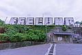
The Keelung Landmark.
-
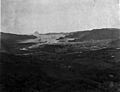
Keelung City and Harbor, between 1860 and 1880.
-
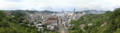
A wide view of central Keelung and the harbor area.


See also
 In Spanish: Keelung para niños
