
Tivoli, New York facts for kids
Quick facts for kids
Tivoli, New York
|
||
|---|---|---|

Downtown Tivoli, looking east
|
||
|
||
| Etymology: Jardin de Tivoli, Paris | ||
| Motto(s):
A Community That Cares
|
||

Location of Tivoli, New York
|
||
.svg)
Location of New York in the United States
|
||
| Country | United States | |
| State | New York | |
| County | Dutchess | |
| Incorporated | 1872 | |
| Government | ||
| • Type | village | |
| Area | ||
| • Total | 1.55 sq mi (4.01 km2) | |
| • Land | 1.54 sq mi (3.99 km2) | |
| • Water | 0.01 sq mi (0.01 km2) | |
| Elevation | 151 ft (46 m) | |
| Highest elevation
(Northeast corner)
|
190 ft (60 m) | |
| Lowest elevation
(Sea level)
|
0 ft (0 m) | |
| Population
(2020)
|
||
| • Total | 1,012 | |
| • Density | 656.29/sq mi (253.38/km2) | |
| Time zone | UTC-5 (Eastern (EST)) | |
| • Summer (DST) | UTC-4 (EDT) | |
| ZIP Code |
12583
|
|
| Area code(s) | 845 | |
| FIPS code | 36-74023 | |
| GNIS feature ID | 0967571 | |

Tivoli is a small village in Dutchess County, New York, United States. In 2020, about 1,012 people lived there. Tivoli became an official village in 1872. It was formed by joining two older communities called Upper Red Hook Landing and Madalin.
Tivoli is the northernmost village in Dutchess County. It is located in the northwestern part of the town of Red Hook. The village is part of a larger group of cities and towns known as the Poughkeepsie–Newburgh–Middletown Metropolitan Statistical Area. It is also part of the even larger New York–Newark–Bridgeport Combined Statistical Area.
The entire village of Tivoli is within the Hudson River Historic District, which is a very important historical area. You can reach Tivoli by using New York State Route 9G where it meets Dutchess County Route 78. The Kaatsbaan Cultural Center, a place for dance, is also located here.
Contents
History of Tivoli
For thousands of years, Native American groups lived in the area where Tivoli is now. When Dutch colonists arrived in the 1600s, the Mohican tribe lived here. The Mohican people came from the Lenni Lenape tribe. They moved north from the coast and settled in what is now the Hudson Valley.
They lived along the Hudson River, which they called Mahicannituck. They called themselves the Muh-he-con-neok, meaning "The People of the Waters That Are Never Still." Because they lived by the river, they were often called the River Indians. Over time, their name changed to Mohican.
Early Land Deals
In July 1683, Robert Livingston bought land from several Mahican Indians. This land deal helps show that the Roeliff Jansen Kill river was the southern border of Mohican land on the east side of the Hudson Valley. This purchase became most of Livingston's large estate.
Historical records say that Colonel David Schuyler bought the land where Tivoli is now from Native American communities on June 2, 1688. However, there are no records of this deal today. Some people wonder if the Mohican Tribe fully understood the European idea of owning land forever. This deal would have involved trading goods for land.
This land deal was part of the Schuyler Patent from June 1688. This patent set the boundaries for some towns and villages in Dutchess County. The land was in the far northwest corner of Dutchess County, east of Magdalen Island (now Cruger Island). The northern border of this land touched the Livingston Purchase from 1683.
How Tivoli Got Its Name
The village was once known as "Upper Red Hook Landing." There was also a nearby community called "Madalin." These two areas were right next to each other.
In the 1790s, a man named Peter Delabegarre (also known as Pierre de la Bigarre) bought land along the Hudson River. This land was south of Chancellor Robert R. Livingston's estate, Clermont. Delabegarre wanted to build a village there and named it "Tivoli." He got the name from a famous Roman resort in Italy. His planned village was never built exactly as he imagined, and he went bankrupt. But the name Tivoli stayed with the area.
The village of Tivoli officially became incorporated in 1872. This meant it joined Madalin and Upper Red Hook Landing together. At that time, the total population was 1,081 people.
Rose Hill Estate
Rose Hill is a historic estate in Tivoli, New York. It has a villa, which is a large country house, built in 1843. The style of the house is Tuscan, like buildings from Tuscany, Italy. John Watts de Peyster built it.
The name Rose Hill came from his grandfather's summer home in Upper Manhattan, which was also called Rose Hill. After de Peyster passed away, the estate became a place for children in need, called the Leake and Watts Orphan House.
In 1964, Dorothy Day of the Catholic Worker Movement bought the estate. They used it as a farm until 1978. Today, in 2017, it is the home of painters Brice and Helen Marden. They also own the Hotel Tivoli.
Geography of Tivoli
Tivoli is located in the northwest corner of Dutchess County. Its exact location is 42°3′34″N 73°54′38″W / 42.05944°N 73.91056°W. The Tivoli Landing area, where Tivoli meets the Hudson River, has natural benefits. These benefits led historians to believe that Native American groups sometimes camped there. The two islands nearby also offered a safe place.
The United States Census Bureau says that the village covers about 4.24 square kilometers (1.64 square miles) in total. Most of this area, about 4.17 square kilometers (1.61 square miles), is land. The rest, about 0.07 square kilometers (0.03 square miles), is water.
Getting Around Tivoli
Main Roads
Tivoli has a few main two-lane roads. County Route 78, which used to be called New York State Route 402, is known as Broadway inside the village. CR 78 ends at the Hudson River. In the past, a ferry used to cross the Hudson River from here to Saugerties in Ulster County.
The second main road is New York State Route 9G. It runs along the eastern edge of the village and crosses CR 78. Route 9G goes north about 19 miles (31 km) to the city of Hudson. It also goes south about 27 miles (43 km) to Poughkeepsie, which is the main city in Dutchess County.
Public Transport
Tivoli has public transportation options. The Bard College shuttle bus serves the village, connecting to the college campus.
Dutchess County Public Transit also runs a bus route, "C," through Tivoli.
If you want to travel to or from New York City, you can take a train. Amtrak trains stop at Rhinecliff, which is about a 12-minute drive from Tivoli. The closest Metro-North train station is in Poughkeepsie, New York, about 45 minutes away.
You can also take a bus to New York City with Trailways. These buses leave from Kingston, which is about a 20-minute drive from Tivoli.
Schools in Tivoli
Tivoli's first schoolhouse was built around 1820 at 71 Broadway. This "Little Red School House" was replaced in 1915 by the building that stands there today. By 1921, this new building taught about 150 students, all the way up to high school. The building has since been changed into apartments.
Children who live in Tivoli attend public schools in the nearby town of Red Hook. These schools include:
- Mill Road Elementary School (for pre-kindergarten through 5th grade) - about 800 students
- Linden Avenue Middle School (for 6th through 8th grade) - about 481 students
- Red Hook Senior High School (for 9th through 12th grade) - about 677 students
Population Information
| Historical population | |||
|---|---|---|---|
| Census | Pop. | %± | |
| 1870 | 452 | — | |
| 1880 | 1,254 | 177.4% | |
| 1890 | 1,350 | 7.7% | |
| 1900 | 1,153 | −14.6% | |
| 1910 | 1,034 | −10.3% | |
| 1920 | 876 | −15.3% | |
| 1930 | 713 | −18.6% | |
| 1940 | 761 | 6.7% | |
| 1950 | 753 | −1.1% | |
| 1960 | 732 | −2.8% | |
| 1970 | 739 | 1.0% | |
| 1980 | 711 | −3.8% | |
| 1990 | 1,035 | 45.6% | |
| 2000 | 1,163 | 12.4% | |
| 2010 | 1,118 | −3.9% | |
| 2020 | 1,012 | −9.5% | |
| U.S. Decennial Census | |||
Based on the census from 2000, Tivoli had 1,163 people living there. There were 487 households, and 261 of these were families. The village had about 662 people per square mile (255 people per square kilometer). There were 531 homes, with about 302 homes per square mile (116 homes per square kilometer).
Most people in the village were white (95.7%). A small number were African American (0.43%), Native American (0.17%), or Asian (0.95%). Some people were from other races (0.69%) or from two or more races (2.06%). About 2.92% of the population was Hispanic or Latino.
In 2000, about 30% of households had children under 18 living with them. About 40.7% were married couples living together. About 9.4% had a female head of household without a spouse. And 46.4% were not families. About 31.4% of all households were people living alone, and 8% had someone living alone who was 65 or older.
The average household had 2.38 people, and the average family had 3.10 people. The population was spread out by age:
- 23.8% were under 18
- 16.8% were 18 to 24
- 28.7% were 25 to 44
- 20.5% were 45 to 64
- 10.2% were 65 or older
The average age in the village was 34 years. For every 100 females, there were about 84.6 males. For every 100 females aged 18 and over, there were about 79.4 males.
The average income for a household in the village was $40,536. For a family, the average income was $53,393. About 6.2% of families and 17.5% of the total population lived below the poverty line. This included 11.9% of those under 18 and 3.8% of those 65 or older.
Kaatsbaan Cultural Center
The Kaatsbaan Cultural Center, located at 120 Broadway in Tivoli, New York, is a special place for dance. It is a non-profit organization that helps dance companies. It gives them a quiet place to stay and work on new dance pieces.
The center was started in 1990 by Gregory Cary, Bentley Roton, Martine van Hamel, and Kevin McKenzie. It is on a property that used to be a 153-acre farm called Tivoli Farms. This farm was once used by Eleanor Roosevelt for horses. The center also has a "music barn" designed by Stanford White, which is being restored.
Gallery
-
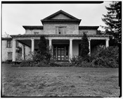
Rose Hill (HABS)
-

The Stanford White-designed Music Barn at Kaatsbaan International Dance Center, formerly Tivoli Farms
-
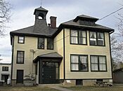
The former school house
-
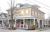
The Hotel Tivoli and The Corner restaurant
-
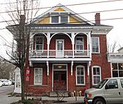
The former Potts Hotel at 54 Broadway


-
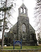
St. Sylvia's Roman Catholic Church
-
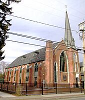
Murray's restaurant is located in this former Methodist church


See also
 In Spanish: Tivoli (Nueva York) para niños
