Tonsa facts for kids
Quick facts for kids Tonsa |
|
|---|---|

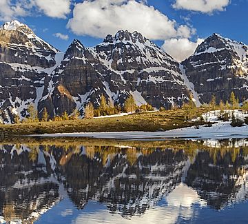
Tonsa (center) seen from Larch Valley flanked by Mount Bowlen on left and Mount Perren on right
|
|
| Highest point | |
| Elevation | 3,053 m (10,016 ft) |
| Prominence | 173 m (568 ft) |
| Parent peak | Mount Bowlen (3072 m) |
| Listing | Mountains of Alberta Mountains of British Columbia |
| Geography | |
| Location | Alberta / British Columbia |
| Parent range | Bow Range Canadian Rockies |
| Topo map | NTS 82N/08 |
Tonsa, also known as Tonsa Peak, is a tall mountain that stands 3,053 meters (about 10,016 feet) high. It is located right on the border between Alberta and British Columbia in the beautiful Canadian Rockies. This mountain is part of the Continental Divide, which is like a giant natural line that separates which way water flows across North America. Water on one side flows to the Pacific Ocean, and water on the other side flows to the Atlantic Ocean.
Tonsa is a stunning part of the scenery around Moraine Lake. This lake is famous for its bright blue water and is found in the Valley of the Ten Peaks within Banff National Park. The mountain got its name in 1894 from Samuel E.S. Allen. He chose the name "Tonsa" because it comes from the Stoney Indian word for the number four.
About Tonsa Mountain
Tonsa is a significant peak in the Bow Range, a part of the larger Canadian Rockies. It's a popular spot for hikers and climbers who want to explore the amazing natural beauty of the area. The mountain offers incredible views of the surrounding valleys and other peaks.
How Tonsa Was Formed
Like many other mountains in Banff National Park, Tonsa is made up of sedimentary rock. This type of rock is formed over millions of years from layers of sand, mud, and tiny bits of ancient sea creatures that settle at the bottom of ancient seas.
- Ancient Seas: Long, long ago, this area was covered by shallow seas.
- Layers of Sediment: Over time, layers of sediment piled up and were pressed together, turning into rock. This happened during periods from the Precambrian era all the way to the Jurassic period.
- Mountain Building: Much later, during a huge event called the Laramide orogeny, powerful forces deep within the Earth pushed these rock layers up. Imagine pushing a rug from both ends – it wrinkles and folds. That's kind of what happened to the Earth's crust, creating mountains like Tonsa. These older rocks were pushed up and even over younger rocks.
Tonsa's Climate
Tonsa is located in a subarctic climate zone. This means it has very cold, snowy winters and mild, cool summers.
- Winter Weather: In winter, temperatures can drop below −20 °C (which is −4 °F). With the wind blowing, it can feel even colder, sometimes below −30 °C (−22 °F).
- Water Flow: The snow and ice that melt from Tonsa's slopes become water. This water flows in two main directions because of the Continental Divide.
- Water on the east side drains into streams that eventually join the Bow River.
- Water on the west side flows into streams that lead to the Vermilion River.
 | Bessie Coleman |
 | Spann Watson |
 | Jill E. Brown |
 | Sherman W. White |


