Toronto waterway system facts for kids
The Toronto waterway system is made up of all the natural and man-made rivers and streams in the city of Toronto, Canada. Big rivers like the Don River, Etobicoke Creek, Highland Creek, Humber River, Mimico Creek and Rouge River flow through the city and into Lake Ontario.
Contents
Toronto's Current Rivers
Toronto has many rivers that flow across the city. All of them eventually empty into Lake Ontario. Some of the most important rivers, like the Don River, the Humber River, and the Rouge River, start far north in a special area called the Oak Ridges Moraine.
List of Rivers
Here's a list of some of Toronto's main rivers and streams, showing where they start and end, and how long they are.
| Name | Smaller Rivers Joining It | Where It Starts | Where It Ends | Length | |
|---|---|---|---|---|---|
| km | mi | ||||
| Black Creek | 43°49′35″N 79°33′34″W | 43°40′10″N 79°30′41″W | |||
| Burke Brook | Havergal Stream | 43°43′14″N 79°24′29″W / 43.720583°N 79.408013°W | 43°43′14″N 79°21′56″W / 43.720586°N 79.365653°W | 9 | 5.6 |
| Deerlick Creek | 43°45'51.3"N 79°19'60.0"W | 43°44'34.7"N 79°20'09.8"W | 3 | 1.9 | |
| Don River | Castle Frank Brook, Yellow Creek, Taylor-Massey Creek, Burke Brook, German Mills Creek, Mud Creek | 43°59′20″N 79°23′57″W | 43°39'02.8"N 79°20'50.2"W | 38 | 24 |
| Duncan Creek | 43°48'05.1"N 79°21'20.5"W | 43°48'29.5"N 79°22'17.4"W | 2 | 1.2 | |
| Etobicoke Creek | Spring Creek, Little Etobicoke Creek | 43°47′19″N 79°53′39″W | 43°35′05″N 79′32′28″W | 61 | 38 |
| German Mills Creek | Duncan Woods Creek | 43°54′42″N 79°28′54″W | 43°47′48″N 79°22′56″W | 10 | 6.2 |
| Highland Creek | West Highland Creek | 43°48′54″N 79°16′51″W | 43°46′0″N 79°08′41″W | 29 | 18 |
| Humber River | Albion Creek, Berry Creek, Black Creek, Centreville Creek, East Humber, Emery Creek, Humber Creek, King Creek, Purpleville Creek, Rainbow Creek,Salt Creek,Silver Creek, West Humber | 43°56′36″N 80°00′14″W | 43°37′56″N 79°28′19″W | 100 | 62 |
| Keating Channel | 43°39′05″N 79°20′52″W | 43°38′46″N 79°21′27″W | 1 | 0.62 | |
| Mimico Creek | 43°44′26″N 79°44′06″W | 43°37′19″N 79°28′54″W | 33 | 21 | |
| Mud Creek | 43°41'40.8"N 79°22'50.7"W | 43°40'57.0"N 79°22'00.6"W | 2 | 1.2 | |
| Rouge River | Little Rouge River, Little Rough Creek, Katabokokohk Creek, Bruce Creek, Beaver Creek | 43°56′07″N 79°24′34″W | 43°47′41″N 79°06′55″W | ||
| Taylor-Massey Creek | 43°46′00″N 79°18′47″W | 43°42′12″N 79′19′59″W | 16 | 9.9 | |
| West Highland Creek | Southwest Highland Creek | 43°49′00″N 79°18′15″W | 43°46′27″N 79°11′58″W | ||
| Yellow Creek | 43°41'27.5"N 79°23'26.3"W | 43°40'47.6"N 79°21'55.8"W | 3 | 1.9 | |
Humber River
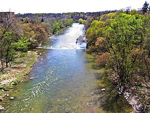
The Humber River is a major river in Southern Ontario, Canada. It flows into Lake Ontario and is one of Toronto's two main rivers. The other main river is the Don River to the east. The Humber River was named a Canadian Heritage River on September 24, 1999. This means it's important for its history and natural beauty.
The Humber River collects water from about 750 smaller creeks and streams. These streams are located in a wide area north of Toronto. The main part of the river is about 100 kilometers (60 miles) long. It starts in the Niagara Escarpment and flows southeast into Lake Ontario. Another big part, called the East Humber River, starts near Aurora. These two parts join north of Toronto. The river then flows into Lake Ontario at the western edge of the city.
Don River
The Don River is another important river in Southern Ontario. It flows into Lake Ontario at Toronto Harbour. The Don River is formed from two main parts, the East Branch and the West Branch. These two parts meet about 7 kilometers (4 miles) north of Lake Ontario. The area below where they meet is called the lower Don. The areas above are called the upper Don.
A third important branch, Taylor-Massey Creek, also joins the Don River where the two main branches meet. The Toronto and Region Conservation Authority (TRCA) helps manage the river and the land around it. The Don Valley is known for its deep, wide valley, which was formed by glaciers long ago. Because the area around the river is very urban, the Don River can have low water levels at times, but also very high floods. The river flows into Lake Ontario at the Keating Channel. The Don River starts in the Oak Ridges Moraine.
Rouge River

The Rouge River flows through several cities in the Greater Toronto Area. These cities include Markham, Pickering, Richmond Hill, and Toronto. The river starts in the Oak Ridges Moraine and flows into Lake Ontario.
The Rouge River is special because it is home to Rouge Park. This is the only national park in Canada that is located inside a city. At its southern end, the Rouge River forms the border between Toronto and Pickering. The Rouge River also starts in the Oak Ridges Moraine.
Toronto's Former Rivers
Toronto also had many rivers that are no longer visible today. These rivers were buried or completely removed as the city grew and developed quickly.
- Ashbridge's Creek
- Bonar Creek
- Castle Field Creek
- Castle Frank Brook
- Cudmore Creek
- Garçon Creek
- Jackson Creek
- Market Steams
- North Creek
- Russell Creek
- Small's Creek
- Superior Creek
- Taddle Creek
- Tomlin's Creek
- Walmsley Creek
- Wendigo Creek
 | William L. Dawson |
 | W. E. B. Du Bois |
 | Harry Belafonte |


