Tredyffrin Township, Pennsylvania facts for kids
Quick facts for kids
Tredyffrin Township
|
|
|---|---|
|
Township
|
|
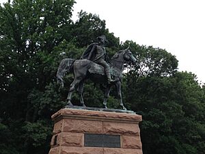
The Anthony Wayne statue in Valley Forge
|
|
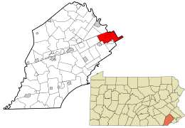
Location of Tredyffrin Township in Chester County and of Chester County in Pennsylvania
|
|
 in the United States]] in the United States]]
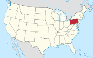
Location of [Pennsylvania[]] in the United States
|
|
| Country | United States |
| State | Pennsylvania |
| County | Chester |
| Founded | 1707 |
| Area | |
| • Total | 19.85 sq mi (51.41 km2) |
| • Land | 19.77 sq mi (51.19 km2) |
| • Water | 0.09 sq mi (0.22 km2) |
| Elevation | 397 ft (121 m) |
| Population
(2010)
|
|
| • Total | 29,332 |
| • Estimate
(2016)
|
29,423 |
| • Density | 1,488.57/sq mi (574.75/km2) |
| Time zone | UTC-5 (EST) |
| • Summer (DST) | UTC-4 (EDT) |
| Area code(s) | 610 |
| FIPS code | 42-029-77344 |
Tredyffrin Township is a community located in eastern Chester County, Pennsylvania, United States. In 2010, about 29,332 people lived here.
Tredyffrin was settled in the late 1600s. It shares a border with Delaware and Montgomery counties. A small part of Valley Forge National Historical Park is on its northern edge. This is where George Washington and his army camped during the American War of Independence. The area is also known for its many limestone deposits. Tredyffrin is the most populated township in Chester County.
Some towns and areas within Tredyffrin Township include Chesterbrook, Strafford, and parts of Paoli and Wayne. It is surrounded by several other townships like Easttown and Upper Merion.
Contents
History of Tredyffrin
How Tredyffrin Began
On March 13, 1684, William Penn set aside land in Province of Pennsylvania for Welsh immigrants. This area was called the "Welsh Tract". Tredyffrin was part of this land. The Welsh Tract was supposed to be self-governing. However, it was divided between Chester County and Philadelphia in 1685. The Welsh then became part of Chester County.
In 1707, Tredyffrin officially became a township. Its name comes from Welsh words: tre(f) means "town", and dyffryn means "wide, cultivated valley". Tredyffrin quickly grew. In 1710, Thomas Jerman started the first mill in the area. Swedesford Road, one of the first roads, was built by 1718.
Growth and Community Life
As more people moved to Tredyffrin, churches were built. In 1722, a log building was put up for the Baptist Church in the Great Valley. This church had started in 1711.
Since Tredyffrin includes part of Valley Forge National Historical Park, it has many sites from the American Revolutionary War. These include the park itself and houses where famous generals stayed.
In the 1800s, the "Main Line" railroad service helped the township grow even more. This train line ended in Paoli, which is on the western edge of the township.
A Step Towards Fairness
The Tredyffrin-Easttown school district was special because it was racially integrated early in the 1900s. In 1932, the district planned to separate students by race after building a new school. African Americans in the township protested this for two years. This event was known as the "School Fight". In 1934, an agreement was reached. The schools stayed integrated, which helped end school segregation in Pennsylvania.
During the Cold War, a Nike anti-aircraft missile site was located in the township. It was used to protect against air attacks.
Historic Places to Visit
Many buildings in Tredyffrin Township are listed on the National Register of Historic Places. This means they are important historical sites. Some of these include:
- County Bridge No. 171
- Cramond
- Cressbrook Farm
- Great Valley Mill
- Greenwood Farm
- Lafayette's Quarters
- Mount Zion A.M.E. Church
- Strafford Railroad Station
- Valley Forge National Historical Park
The Wharton Esherick Museum is also a National Historic Landmark. It was built starting in 1926.
Other interesting old buildings are:
- Diamond Rock Schoolhouse: An eight-sided, one-room school built in 1818.
- Seven colonial log houses and cabins.
- Knox Covered Bridge: Found in Valley Forge National Historical Park.
- Revolutionary War sites: Quarters of generals like Major General William Alexander, Lord Stirling; Major General Marquis de Lafayette; and Brigadier General Anthony Wayne.
- Old Eagle School: Built in 1788.
Geography and Climate
Tredyffrin Township covers about 19.9 square miles (51.41 square kilometers). Most of this area is land, with a small amount of water.
The climate in Tredyffrin is usually warm in summer and cold in winter. It's a mix of hot-summer humid continental and humid subtropical. The area is in hardiness zone 7a, which means certain plants can grow well here.
Getting Around Tredyffrin
Tredyffrin Township has many roads. As of 2018, there were over 150 miles of public roads. Some are maintained by the state, and others by the township itself.
Major roads include:
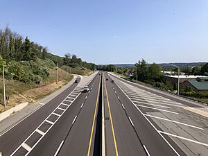
- The Pennsylvania Turnpike (I-76): This important highway runs across the northwestern part of the township.
- U.S. Route 202: This road also crosses the center of the township.
- U.S. Route 422: This route starts in the northeastern part of the township.
- U.S. Route 30: Also known as Lancaster Avenue, it runs through the southern section.
- Pennsylvania Route 252: This road goes north to south through the middle of the township.
People of Tredyffrin
Tredyffrin Township is a diverse community. In 2010, most residents were White (83.3%), with a significant number of Asian (9.8%) and Black or African American (3.3%) residents. About 2.2% of the population was of Hispanic or Latino background.
In 2000, there were about 29,062 people living in the township. The average household had about 2.36 people. Many households were married couples living together. About 29% of households had children under 18. The median age in the township was 40 years old.
The average income for a household in Tredyffrin was quite high, showing that many families in the area have good jobs.
Geology of the Area
The rocks in Tredyffrin were formed a very long time ago, mainly during the upper Paleozoic era. This means they are mostly metamorphic rocks. Limestone is often found near the surface in the Great Valley. Because of this, many limestone kilns were built in the 1700s. These kilns were used to process limestone.
The northern part of the township has a ridge made of quartzite and sandstone. This includes Valley Forge Mountain, which was mined for quartz from the 1700s to the mid-1800s.
Education in Tredyffrin
Schools for Kids and Teens
Tredyffrin Township is part of the Tredyffrin/Easttown School District. Students living here attend different schools based on their age:
- Elementary Schools (Grades K-4): Hillside Elementary School, New Eagle Elementary School, and Valley Forge Elementary School.
- Middle Schools (Grades 5-8): Tredyffrin/Easttown Middle School and Valley Forge Middle School.
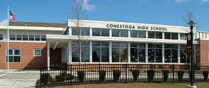
- High School (Grades 9-12): Conestoga High School.
There are also several private schools in the township:
- Delaware Valley Friends School in Paoli
- Devon Preparatory School (grades 6–12) in Devon
- Woodlynde School in Strafford
- Heritage School (preschool) in Wayne
- Vanguard School (special education) in Paoli
Public Libraries
Tredyffrin Township Libraries runs two libraries: Tredyffrin Public Library and Paoli Library.
The Tredyffrin Library is located in the Strafford community. It's a large building with plenty of space for reading and learning. The library has a special outdoor amphitheater that faces a park. In 1990, a new children's library section was added on the lower level.
In 2004, plans were made to update and expand the Tredyffrin Library. A big renovation project started in 2007, costing $6 million. The newly expanded building opened to the public on January 31, 2009. The library is designed to let in lots of natural light and make it easy to find what you need.
See also
 In Spanish: Municipio de Tredyffrin para niños


