Tukgahgo Mountain facts for kids
Quick facts for kids Tukgahgo Mountain |
|
|---|---|

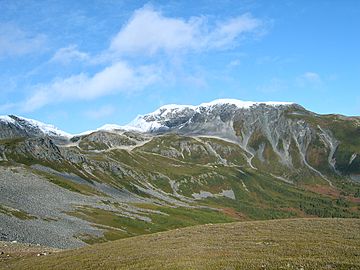
Mount Tukgahgo in early fall.
|
|
| Highest point | |
| Elevation | 4,675 ft (1,425 m) |
| Geography | |
| Location | Haines Borough, Alaska, U.S. |
| Parent range | Takshanuk Mountains (Coast Mountains) |
| Topo map | USGS Skagway (B-2) |
| Climbing | |
| First ascent | Unknown |
| Easiest route | Scramble |
Tukgahgo Mountain (say it: TUG-a-ho) is a cool mountain in Alaska, a state in the U.S.. It's part of the Takshanuk Mountains. This mountain stands tall at about 4,675 feet (1,425 meters) high!
Tukgahgo Mountain is found in Haines Borough. It's about 3.5 miles southwest of Chilkoot Lake. It's also about 16 miles southwest of Skagway. Scientists have studied the rocks here. They found special veins in the mountain. These veins contain valuable metals like silver, gold, platinum, and palladium. These metals formed a long, long time ago, during the middle of the Cretaceous period.
Where is Tukgahgo Mountain?
The name "Tukgahgo" comes from the Tlingit people. They are the native people of this area. A geologist named Eugene C. Robertson wrote down the name. The United States Geological Survey (USGS) published it in 1952.
Tukgahgo Mountain is located about 3.5 miles southwest of Chilkoot Lake. The town of Skagway is about 16 miles to the northeast. Another place called Vanderbilt Point is about 3 miles west of the mountain's top. On the east side of the mountain, you can find the start of Shakuseyi Creek.
What is Tukgahgo Mountain Made Of?
Scientists looked closely at the rocks around Tukgahgo Mountain in 1991. They studied a rock area about 2,500 feet southwest of the mountain. This area is near a peak called Chilly Peak, which is about 4,520 feet high.
The rocks in this area are mostly metabasalts and amphibolites. These are types of rocks that have changed over time due to heat and pressure. They are surrounded by other rocks like diorite and granodiorite. Scientists think these rocks are part of a larger rock body called the Mount Kashagnak pluton.
There are also some quartz veins scattered around. These veins are important because they are part of a small crack in the Earth's crust called the Tukgahgo Mountain fault. This fault is close to the mountain's summit. Along this fault, different types of rocks meet.
Scientists took samples from these veins. They tested them for metals like molybdenum, platinum, and palladium. One vein had a lot of molybdenite, which is a mineral containing molybdenum. It had 1,240 parts per million of it!
The quartz veins also contained other minerals. These included pyrite, chalcopyrite, malachite, and molybdenite. They found some gold in the samples, about 0.824 parts per million. There was also silver (2.70 parts per million) and copper (2,140 parts per million).
These metals formed during the middle of the Cretaceous period. This means they are very, very old! Even though these valuable metals are found here, there haven't been any mining operations reported on Tukgahgo Mountain.
 | Victor J. Glover |
 | Yvonne Cagle |
 | Jeanette Epps |
 | Bernard A. Harris Jr. |


