Twiggs County, Georgia facts for kids
Quick facts for kids
Twiggs County
|
|
|---|---|

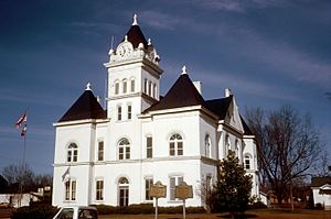
Twiggs County Courthouse, Jeffersonville
|
|

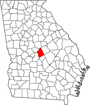
Location within the U.S. state of Georgia
|
|
 Georgia's location within the U.S. |
|
| Country | |
| State | |
| Founded | December 14, 1809 |
| Named for | John Twiggs |
| Seat | Jeffersonville |
| Largest city | Jeffersonville |
| Area | |
| • Total | 363 sq mi (940 km2) |
| • Land | 358 sq mi (930 km2) |
| • Water | 4.2 sq mi (11 km2) 1.2%% |
| Population
(2020)
|
|
| • Total | 8,022 |
| • Density | 22/sq mi (8/km2) |
| Time zone | UTC−5 (Eastern) |
| • Summer (DST) | UTC−4 (EDT) |
| Congressional district | 8th |
Twiggs County is a county located in the central part of the U.S. state of Georgia. In 2020, about 8,022 people lived here. The main town and county seat is Jeffersonville.
The county was started on December 14, 1809. It was named after John Twiggs, who was a general in the American Revolutionary War. Twiggs County is also part of the larger Macon city area.
Contents
Exploring Twiggs County's Land
Twiggs County covers about 363 square miles. Most of this area, 358 square miles, is land. Only a small part, about 4.2 square miles, is water.
Land Features and Rivers
Twiggs County is special because it sits on the fall line. This is a natural boundary where the land changes. The northern parts of the county have more hills. This area is part of the Piedmont region. The southern parts are flatter. They are part of the upper Atlantic coastal plain.
The exact middle point of Georgia is actually in Twiggs County. You can find it near Bullard Road.
Several rivers flow through or near the county. The Ocmulgee River and the Oconee River are important. These rivers are part of the larger Altamaha River basin.
Main Roads in Twiggs County
Many important roads help people travel through Twiggs County. These roads connect the county to other parts of Georgia and beyond.
 Interstate 16
 U.S. Route 23
 U.S. Route 80
 U.S. Route 129 Alternate
 State Route 18
 State Route 19
 State Route 57
 State Route 87
 State Route 96
 State Route 112
 State Route 358
 State Route 404 (this is another name for I-16)
 State Route 540
Neighboring Counties
Twiggs County shares its borders with several other counties:
- Wilkinson County (to the northeast)
- Laurens County (to the southeast)
- Bleckley County (to the south)
- Houston County (to the southwest)
- Bibb County (to the west)
- Jones County (to the northwest)
Protected Natural Areas
Part of the Bond Swamp National Wildlife Refuge is located in Twiggs County. This area helps protect wildlife and their homes.
Towns and Communities
Twiggs County has a few towns and communities where people live.
Cities
- Allentown: This city is partly in Twiggs County and also in Wilkinson, Laurens, and Bleckley counties.
- Jeffersonville: This is the main town and the county seat.
Town
- Danville: This town is partly in Twiggs County and also in Wilkinson County.
Unincorporated Community
- Dry Branch: This community is partly in Twiggs County and also in Bibb County.
People of Twiggs County
The population of Twiggs County has changed over the years. In 2020, there were 8,022 people living there.
| Historical population | |||
|---|---|---|---|
| Census | Pop. | %± | |
| 1810 | 3,405 | — | |
| 1820 | 10,640 | 212.5% | |
| 1830 | 8,031 | −24.5% | |
| 1840 | 8,422 | 4.9% | |
| 1850 | 8,179 | −2.9% | |
| 1860 | 8,320 | 1.7% | |
| 1870 | 8,545 | 2.7% | |
| 1880 | 8,918 | 4.4% | |
| 1890 | 8,195 | −8.1% | |
| 1900 | 8,716 | 6.4% | |
| 1910 | 10,736 | 23.2% | |
| 1920 | 10,407 | −3.1% | |
| 1930 | 8,372 | −19.6% | |
| 1940 | 9,117 | 8.9% | |
| 1950 | 8,308 | −8.9% | |
| 1960 | 7,935 | −4.5% | |
| 1970 | 8,222 | 3.6% | |
| 1980 | 9,354 | 13.8% | |
| 1990 | 9,806 | 4.8% | |
| 2000 | 10,590 | 8.0% | |
| 2010 | 9,023 | −14.8% | |
| 2020 | 8,022 | −11.1% | |
| 2023 (est.) | 7,691 | −14.8% | |
| U.S. Decennial Census 1790-1880 1890-1910 1920-1930 1930-1940 1940-1950 1960-1980 1980-2000 2010 |
|||
Diversity in Twiggs County (2020)
The people living in Twiggs County come from different backgrounds.
| Group | Number | Percentage |
|---|---|---|
| White (not Hispanic) | 4,487 | 55.93% |
| Black or African American (not Hispanic) | 3,099 | 38.63% |
| Native American | 16 | 0.2% |
| Asian | 37 | 0.46% |
| Other/Mixed backgrounds | 259 | 3.23% |
| Hispanic or Latino | 124 | 1.55% |
In 2020, there were 8,022 people living in 3,044 households. These households included 1,838 families.
Learning in Twiggs County
The Twiggs County School District manages all the public schools in the county.
- Jefersonville Elementary
- Twiggs County Comprehensive Middle/High School
There is also a private school:
- Twiggs Academy
Famous People from Twiggs County
Several notable people have connections to Twiggs County:
- Philip Cook: He was a general during the American Civil War. Later, he served in the U.S. Congress.
- Darqueze Dennard: A professional football player. He played as a cornerback for the Cincinnati Bengals. He also won the Jim Thorpe Award in 2013.
- Dudley Mays Hughes: An American politician and farmer. He was a member of the U.S. House of Representatives.
- Chuck Leavell: A famous musician. He played with The Allman Brothers Band and is a long-time touring member of The Rolling Stones. He also owns a tree farm in Twiggs County.
See also
 In Spanish: Condado de Twiggs para niños


