Vian, Oklahoma facts for kids
Quick facts for kids
Vian, Oklahoma
Cherokee: ᏓᏄᎪᎢ
|
|
|---|---|

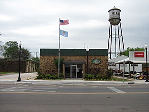
Vian Town Hall
|
|

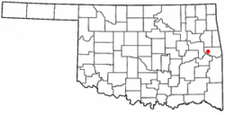
Location of Vian, Oklahoma
|
|
| Country | United States |
| State | Oklahoma |
| County | Sequoyah |
| Area | |
| • Total | 1.38 sq mi (3.58 km2) |
| • Land | 1.34 sq mi (3.47 km2) |
| • Water | 0.04 sq mi (0.11 km2) |
| Elevation | 558 ft (170 m) |
| Population
(2020)
|
|
| • Total | 1,374 |
| • Density | 1,026.91/sq mi (396.37/km2) |
| Time zone | UTC-6 (Central (CST)) |
| • Summer (DST) | UTC-5 (CDT) |
| ZIP code |
74962
|
| Area code(s) | 539/918 |
| FIPS code | 40-77250 |
| GNIS feature ID | 2413431 |
Vian (which means "gar-place" in the Cherokee language) is a small town in Sequoyah County, Oklahoma, United States. It is located right next to Interstate 40, where it meets U.S. Route 64 and Oklahoma State Highway 82. In 2020, about 1,374 people lived there. Vian is part of the larger Fort Smith metropolitan area.
Contents
History
When Europeans first arrived, the land around Vian was used by the Osage for hunting. The name "Vian" comes from the French word viande, which means "meat." French traders called a nearby creek "bayou viande," meaning "meat bayou."
This area became part of the Missouri Territory in 1816. Later, it was part of the Arkansas Territory. After the Indian Removal Act, the Cherokee Nation gained control of the land. The Dwight Presbyterian Mission was also moved to this area.
Vian started as a trading post between two creeks, Big Vian and Little Vian. In 1886, a post office was opened. The first postmaster, Mahala Thompson, wanted to name the town Round Mountain, but that name was already taken. So, the post office was named Vian, after the two creeks.
In 1888, a railway line was built through Vian. This made the town an important place for shipping cotton. By 1901, about 2,500 to 3,000 bales of cotton were shipped each year. When Oklahoma became a state in 1907, Vian became part of the new state. Today, Vian is within the area of the modern Cherokee Nation of Oklahoma.
Vian's schools started in the late 1880s with a mission school for Cherokee children. A school for white children opened in the 1890s. Douglass High School in Vian served African-American students in the area. The schools in Vian became integrated in the mid-1950s.
Today, Vian's economy mostly relies on tourism and services. This is because it is located along Interstate 40 and is close to places like Sequoyah National Wildlife Refuge, Robert S. Kerr Reservoir, and Tenkiller Ferry Lake. Farming is also still a big part of the local economy.
Geography
Vian is located about 11 miles (18 km) west of Sallisaw.
The United States Census Bureau says the town covers a total area of about 0.8 square miles (2.1 square kilometers). All of this area is land.
Demographics
| Historical population | |||
|---|---|---|---|
| Census | Pop. | %± | |
| 1900 | 296 | — | |
| 1910 | 794 | 168.2% | |
| 1920 | 1,176 | 48.1% | |
| 1930 | 900 | −23.5% | |
| 1940 | 941 | 4.6% | |
| 1950 | 927 | −1.5% | |
| 1960 | 930 | 0.3% | |
| 1970 | 1,131 | 21.6% | |
| 1980 | 1,521 | 34.5% | |
| 1990 | 1,414 | −7.0% | |
| 2000 | 1,362 | −3.7% | |
| 2010 | 1,466 | 7.6% | |
| 2020 | 1,374 | −6.3% | |
| U.S. Decennial Census | |||
In 2000, there were 1,362 people living in Vian. There were 503 households, and 339 families. About 35.4% of households had children under 18. The average household had 2.49 people, and the average family had 3.10 people.
The population was spread out by age. About 28.6% were under 18, and 18.9% were 65 or older. The average age was 36 years.
The median income for a household in Vian was $18,264. For a family, it was $24,167. About 35.6% of the population lived below the poverty line. This included 42.2% of those under 18 and 33.5% of those 65 or older.
Notable people
- Maggie Culver Fry (1900–1998), a poet laureate of Oklahoma
- Franklin Gritts, a Cherokee painter
- Captain Frederick F. Henry, a United States Army soldier who received the Medal of Honor in the Korean War
- Richard Jordan, an NFL linebacker for the Kansas City Chiefs and Detroit Lions
- Bobby Ussery, a Hall of Fame jockey
- Kenyatta Wright, an NFL Linebacker for the New York Jets
See also
 In Spanish: Vian (Oklahoma) para niños
 | Sharif Bey |
 | Hale Woodruff |
 | Richmond Barthé |
 | Purvis Young |

