Ware, Massachusetts facts for kids
Quick facts for kids
Ware, Massachusetts
|
|||
|---|---|---|---|
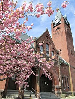
Ware, MA, Town Hall
|
|||
|
|||
| Nickname(s):
"The Town That Can't Be Licked" "A Place Worth Visiting"
|
|||
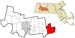
Location in Hampshire County in Massachusetts
|
|||
| Country | United States | ||
| State | Massachusetts | ||
| County | Hampshire | ||
| Settled | 1717 | ||
| Incorporated | 1775 | ||
| Government | |||
| • Type | Open Town Meeting | ||
| Area | |||
| • Total | 40.0 sq mi (103.5 km2) | ||
| • Land | 34.4 sq mi (89.0 km2) | ||
| • Water | 5.6 sq mi (14.5 km2) | ||
| Elevation | 475 ft (145 m) | ||
| Population
(2020)
|
|||
| • Total | 10,066 | ||
| • Density | 287/sq mi (110.9/km2) | ||
| Time zone | UTC−5 (Eastern) | ||
| • Summer (DST) | UTC−4 (Eastern) | ||
| ZIP Code |
01082
|
||
| Area code(s) | 413 | ||
| FIPS code | 25-72880 | ||
| GNIS feature ID | 0618209 | ||
Ware is a town in Hampshire County, Massachusetts, United States. It is a part of the Springfield, Massachusetts metropolitan area. In 2020, about 10,066 people lived there.
The main part of the town, called Ware, is in the southeastern corner. Students in the area attend Ware Junior Senior High School.
Contents
Discovering Ware's Past
Ware was first settled in 1717 and became an official town in 1775. Its name comes from the word "weir." Native Americans built weirs to catch fish in the Ware River. English settlers later pronounced the word "ware."
Early Settlements and Growth
In 1716, a large piece of land (over 11,000 acres) was given to John Read. He called it "The Manor of Peace." He hoped it would become a valuable country estate. He rented out the land and did not sell any until after he died. He gave 200 acres for a church. Over time, the town of Ware grew around the old Congregational meeting house. It became a small center for making goods and trading.
In 1729, the first mills were built on the Weir River by Jabez Olmstead. These mills later became part of the Ware Millyard Historic District. During the American Revolutionary War, Ware had many taverns and inns. Two famous ones were Ebenezer Nye's and John Downing's. Town meetings often ended at Downing's place.
By the 1830s, many textile mills appeared along the local rivers. Ware was changing from a farming community to one based on factories. After the American Civil War (1860s–1900s), the textile mill town became very rich. "Ware factory village" grew quickly and led to new growth.
The Otis Company and Community Spirit
For almost 100 years, the Otis company was the biggest employer in Ware. They used cotton to make things like denims and awnings. The company was very successful until World War I, with nearly 2,500 workers. But by the 1920s, the company started to struggle. This was because their machines were old, and many industries were moving south.
In 1922, the mills in Ware closed during the 1922 New England Textile Strike because of a planned wage cut.
By the mid-1930s, the company decided to close down completely. The townspeople quickly came together. They held a public meeting to raise money to save the town from ruin. The people of Ware bought the mills with help from the Ware Trust Company. The mills became Ware Industries Inc. Because of this, Ware became known across the country as "The Town That Can't Be Licked."
Expanding Ware's Borders
In the late 1930s, Ware gained more land. This happened when the Quabbin Reservoir was built. The reservoir flooded the valley of the Swift River. Four towns—Enfield, Greenwich, Prescott, and Dana—were closed down in 1938 because of the reservoir. Much of Enfield and Greenwich became part of Ware, making the town larger to the north.
Today, Ware is home to most of the Winsor Dam and its spillway, and the Goodnough Dike. These are both part of the Quabbin Reservation. Ware's part of this land is easy to visit. It has a large lookout tower on Quabbin Hill. Ware also has the Quabbin Park Cemetery. Most of the graves and town monuments from the flooded towns were moved here.
Historic Areas to Explore
Ware has several special historic areas:
Geography and Getting Around Ware
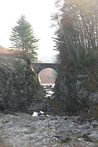
Ware covers about 103.5 square kilometers (40 square miles). About 89.0 square kilometers (34.4 square miles) is land, and 14.5 square kilometers (5.6 square miles) is water. Ware is at the southern end of the Quabbin Reservoir. The land within the town includes two islands, Little Quabbin Hill and Mount Lizzie. These islands were not covered by the reservoir's water.
The Swift River forms Ware's western border. The Ware River flows through the southeastern part of town. These rivers meet in Palmer to form the Chicopee River. The Chicopee River then flows into the Connecticut River. The land in Ware is hilly between the Swift and Ware river valleys. Much of the land outside the town center is covered in forests. There are also marshes along the Ware River. The Herman Covey–Swift River Wildlife Management Area is along the Swift River.
Ware is the easternmost town in Hampshire County. It borders Franklin County to the north, Worcester County to the east, and Hampden County to the south. Ware is about 24 miles east-southeast of Northampton. It is 26 miles northeast of Springfield and 72 miles west of Boston.
Ware does not have any major highways. The town center is about 8.5 miles north of Exit 63 (the Palmer exit) of Interstate 90. Route 9 is a main east-west road through central Massachusetts. Route 32 connects Ware to Route 9. Route 9 goes west through town, near the Quabbin Reservation.
Ware does not have public transportation. However, it has a commercial train line, the Massachusetts Central Railroad. This line follows the Ware River. There is also a small private airport in the eastern part of town. The closest major airports are Bradley International Airport in Connecticut and Worcester Regional Airport in Massachusetts.
People Living in Ware
| Historical population | ||
|---|---|---|
| Year | Pop. | ±% |
| 1850 | 3,785 | — |
| 1860 | 3,597 | −5.0% |
| 1870 | 4,259 | +18.4% |
| 1880 | 4,817 | +13.1% |
| 1890 | 7,329 | +52.1% |
| 1900 | 8,263 | +12.7% |
| 1910 | 8,774 | +6.2% |
| 1920 | 8,525 | −2.8% |
| 1930 | 7,385 | −13.4% |
| 1940 | 7,557 | +2.3% |
| 1950 | 7,517 | −0.5% |
| 1960 | 7,517 | +0.0% |
| 1970 | 8,187 | +8.9% |
| 1980 | 8,953 | +9.4% |
| 1990 | 9,808 | +9.5% |
| 2000 | 9,707 | −1.0% |
| 2010 | 9,872 | +1.7% |
| 2020 | 10,066 | +2.0% |
| 2022 | 10,385 | +3.2% |
In 2000, there were 9,707 people living in Ware. There were 4,027 households and 2,597 families. The population density was about 282 people per square mile.
About 96.49% of the people were White. Other groups included Black (0.55%), Native American (0.23%), and Asian (0.60%). About 2.08% of the population was Hispanic or Latino.
About 29.8% of households had children under 18. About 46.8% were married couples. The average household had 2.41 people, and the average family had 2.96 people.
The median age in town was 38 years old. About 24.7% of the population was under 18. About 15.1% were 65 or older.
The median income for a household was $36,875. For a family, it was $45,505. About 11.2% of the population lived below the poverty line. This included 16.8% of those under 18.
Famous People from Ware
Many interesting people have connections to Ware:
- Braddish Billings: A farmer who helped build Billings Bridge in Ottawa.
- Samuel Colt: The inventor of the repeating pistol.
- Dick Curless: A country music singer.
- Shamus Culhane: An animator and director who worked at Walt Disney Studios.
- Candy Cummings: A baseball player from the 1870s. He is said to have invented the curveball.
- Bertha Knight Landes: The mayor of Seattle, Washington, from 1926 to 1928. She was the first female mayor of a major American city.
- Karen S. Lynch: The president and CEO of CVS Health, one of the world's largest companies.
- Jennifer Lafleur: An actress who appeared in the film Nope.
- Ruth Baker Pratt: The first congresswoman elected from New York.
- Billy Jo Robidoux: A major league baseball player.
- Don Rondo: A singer.
- Dana White: The president of the Ultimate Fighting Championship.
See also
 In Spanish: Ware (Massachusetts) para niños


