Way of the Roses facts for kids
Quick facts for kids Way of the Roses |
|
|---|---|

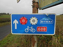
A typical Way of the Roses sign showing the red and white roses, a direction arrow and route number
|
|
| Established | 2010 |
| Length | 170 mi (274 km) |
| Location | Lancashire & Yorkshire, United Kingdom |
| Designation | NCN routes
|
| Trailheads | Morecambe (west) 54°04′16″N 2°52′34″W / 54.0710°N 2.8760°W Bridlington (east) 54°05′33″N 0°10′38″W / 54.0924°N 0.1772°W |
| Use | cycling pedestrians |
| Elevation | |
| Highest point | Greenhow, 1,325 ft (404 m) |
| Cycling details | |
| Waymark |  |
| Surface | Varies from on-road, to traffic-free tarmac, compacted surface and cinder track |
| Website | Guide to the Way of the Roses |
| Trail map | |

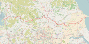
Map of the Way of the Roses cycle route
|
|
The Way of the Roses is a famous long-distance bike route in Great Britain. It stretches from one coast to the other! This route uses quiet country roads, old railway lines, and special cycle paths. It goes through the counties of Lancashire and Yorkshire in northern England.
Along the way, you'll cross the beautiful Yorkshire Dales and the Yorkshire Wolds. You'll also pass through historic cities like Lancaster and York. Plus, you'll see charming towns and villages such as Settle, Pateley Bridge, and Ripon.
The route is about 170 miles (274 km) long. It's made for all kinds of cyclists, from families to serious bike club riders. It can be a bit challenging with some steep hills. The highest point is over 1,312 feet (400 meters) high! But it's becoming more and more popular. The entire route is open and has clear signs to guide you.
The name "Way of the Roses" comes from the Wars of the Roses. This was a war in the 15th century between two English families: Lancaster and York. Each family had a rose as its symbol.
Contents
History of the Way of the Roses
The Way of the Roses route was created by an organization called Sustrans. They work to make it easier for people to walk and cycle. This route is part of the National Cycle Network. It opened in 2010.
The route starts in Morecambe on the west coast of Lancashire. It finishes on the east coast at Bridlington. In 2011, a new part of the route opened. This section goes between Pateley Bridge and York, passing through Harrogate and Knaresborough. There's also a link that connects Kingston upon Hull to the main route.
Art Along the Way
Artists have created special artworks for the Way of the Roses. One artist, Matt Baker, is making a series of connected artworks. These will be placed at different spots along the route.
Exploring the Route
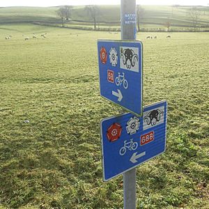
The Way of the Roses is very well signposted. The signs have the route's name on them. They also show the red and white heraldic roses. These roses are why the route has its name!
The journey begins in the seaside town of Morecambe, Lancashire. It generally follows the River Lune and the River Wenning. Then it climbs into the Pennine mountains near Settle. Here, you enter the beautiful Yorkshire Dales National Park.
The route's steepest climb (when heading east) is near Rye Loaf Hill. After that, you go downhill to Airton. Next, you head northeast to Grassington. You'll follow the River Wharfe for several miles. Then, you turn towards the highest point of the route at Greenhow. From there, it's downhill to Pateley Bridge on the River Nidd.
After Pateley Bridge, the hills become much smaller. Once you pass Ripon, the route is mostly flat. The only exception is a short section in the Yorkshire Wolds. Finally, you cycle through York before reaching Bridlington and the North Sea.
The route is mostly made up of:
- quiet country roads (about 90%)
- short sections through towns on main roads (about 5%)
- special cycle paths and old railway lines (about 5%)
It's usually best to ride the Way of the Roses from west to east. This way, you get help from the prevailing winds that blow from the west. Also, the hills are easier to climb in this direction. A fun tradition is to dip your back wheel in the Irish Sea at the start. Then, you dip your front wheel in the North Sea at the finish! Most people complete the route in 3 to 5 days.
Connecting Cycle Routes
The Way of the Roses uses parts of 8 different National Cycle Network (NCN) routes. It starts in Morecambe on Route 69. Then it joins Route 68 at Clapham. Next, it moves to Route 688 at Winterburn. After that, it uses Route 65 at Linton-on-Ouse.
When you go through central York, you'll follow the short Route 658. Then it joins Route 66. At Pockington, the route takes Route 164 over the Yorkshire Wolds. Finally, it picks up Route 1 near Hutton Cranswick. This route then takes you all the way to the finish in Bridlington.
The Way of the Roses also connects to other NCN routes. This means you can use it as part of a longer cycle tour. For example, it connects with Route 700 at Morecambe. It also meets Route 6 at Lancaster. You can find junctions with Route 67 near Fountains Abbey. And it links to Route 167 at Huggate in the Yorkshire Wolds.
You can find maps and detailed guides for the Way of the Roses from Sustrans.
 | Ernest Everett Just |
 | Mary Jackson |
 | Emmett Chappelle |
 | Marie Maynard Daly |


