
Wayne County, Illinois facts for kids
Quick facts for kids
Wayne County
|
|
|---|---|

Wayne County Courthouse in Fairfield
|
|

Location within the U.S. state of Illinois
|
|
 Illinois's location within the U.S. |
|
| Country | |
| State | |
| Founded | 1819 |
| Named for | Anthony Wayne |
| Seat | Fairfield |
| Largest city | Fairfield |
| Area | |
| • Total | 715 sq mi (1,850 km2) |
| • Land | 714 sq mi (1,850 km2) |
| • Water | 1.7 sq mi (4 km2) 0.2% |
| Population
(2020)
|
|
| • Total | 16,179 |
| • Density | 22.628/sq mi (8.737/km2) |
| Time zone | UTC−6 (Central) |
| • Summer (DST) | UTC−5 (CDT) |
| Congressional district | 12th |
Wayne County is a county located in the state of Illinois, United States. In 2020, about 16,179 people lived here. The main town and county seat is Fairfield. Wayne County is in the southern part of Illinois, an area sometimes called "Little Egypt".
Contents
History of Wayne County
Wayne County was created in 1819. It was formed from parts of Edwards County.
The county is named after General "Mad Anthony" Wayne. He was a brave officer. He fought in the Revolutionary War and the Northwest Indian War.
-
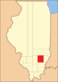
Wayne County between its 1819 creation and 1821
-

Wayne County between 1821 and 1824
-
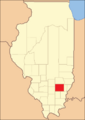
Wayne County in 1824, reduced to its current size


Geography of Wayne County
Wayne County covers a total area of about 715 square miles. Most of this area, 714 square miles, is land. Only a small part, about 1.7 square miles, is water.
Weather and Climate in Wayne County
| Weather chart for Fairfield, Illinois | |||||||||||||||||||||||||||||||||||||||||||||||
|---|---|---|---|---|---|---|---|---|---|---|---|---|---|---|---|---|---|---|---|---|---|---|---|---|---|---|---|---|---|---|---|---|---|---|---|---|---|---|---|---|---|---|---|---|---|---|---|
| J | F | M | A | M | J | J | A | S | O | N | D | ||||||||||||||||||||||||||||||||||||
|
2.8
37
20
|
2.7
43
24
|
4.6
54
33
|
4.8
66
43
|
4.7
76
52
|
4.2
85
61
|
3.8
88
65
|
3.4
87
63
|
2.9
80
55
|
3.3
68
44
|
4.3
53
34
|
Expression error: Unrecognized punctuation character "{".
<div style="overflow:hidden;background:#e44;position:absolute;left:.4em;width:0.8em;z-index:4;bottom:Expression error: Unrecognized punctuation character "{".em;height:Expression error: Unrecognized punctuation character "{".em;"> <div style="color:red;position:absolute;bottom:Expression error: Unrecognized punctuation character "{".em; left:0;width:1.5em;height:1.5em;text-align:center;z-index:4">Expression error: Unrecognized punctuation character "{". <div style="color:red;position:absolute;bottom:Expression error: Unrecognized punctuation character "{".em; left:0;width:1.5em;height:1.5em;text-align:center;z-index:4">Expression error: Unrecognized punctuation character "{". |
||||||||||||||||||||||||||||||||||||
| temperatures in °F precipitation totals in inches source: The Weather Channel |
|||||||||||||||||||||||||||||||||||||||||||||||
|
Metric conversion
<div style="color:red;position:absolute;bottom:Expression error: Unrecognized punctuation character "{".em; left:-.4em;width:1.6em;height:1.5em;text-align:right;">Expression error: Unrecognized punctuation character "{".<div style="color:red;position:absolute;bottom:Expression error: Unrecognized punctuation character "{".em; left:-.4em;width:1.6em;height:1.5em;text-align:right;">Expression error: Unrecognized punctuation character "{".
|
|||||||||||||||||||||||||||||||||||||||||||||||
In Fairfield, the county seat, temperatures change throughout the year. In January, the average low is 20°F. In July, the average high is 88°F.
The coldest temperature ever recorded was -23°F in January 1994. The hottest was 113°F in July 1901. Rainfall also varies. February usually gets about 2.70 inches of rain. April gets the most, with about 4.80 inches.
Getting Around Wayne County
- Rides Mass Transit District
Main Roads in Wayne County
 Interstate 64
 U.S. Highway 45
 Illinois Route 15
 Illinois Route 242
Neighboring Counties
Wayne County shares borders with several other counties:
- Clay County (to the north)
- Richland County (to the northeast)
- Edwards County (to the east)
- White County (to the southeast)
- Hamilton County (to the south)
- Jefferson County (to the southwest)
- Marion County (to the northwest)
People of Wayne County
| Historical population | |||
|---|---|---|---|
| Census | Pop. | %± | |
| 1820 | 1,114 | — | |
| 1830 | 2,553 | 129.2% | |
| 1840 | 5,133 | 101.1% | |
| 1850 | 6,825 | 33.0% | |
| 1860 | 12,223 | 79.1% | |
| 1870 | 19,758 | 61.6% | |
| 1880 | 21,291 | 7.8% | |
| 1890 | 23,806 | 11.8% | |
| 1900 | 27,626 | 16.0% | |
| 1910 | 25,697 | −7.0% | |
| 1920 | 22,772 | −11.4% | |
| 1930 | 19,130 | −16.0% | |
| 1940 | 22,092 | 15.5% | |
| 1950 | 20,933 | −5.2% | |
| 1960 | 19,008 | −9.2% | |
| 1970 | 17,004 | −10.5% | |
| 1980 | 18,059 | 6.2% | |
| 1990 | 17,241 | −4.5% | |
| 2000 | 17,151 | −0.5% | |
| 2010 | 16,760 | −2.3% | |
| 2020 | 16,179 | −3.5% | |
| 2023 (est.) | 15,761 | −6.0% | |
| U.S. Decennial Census 1790-1960 1900-1990 1990-2000 2010 |
|||
In 2010, there were 16,760 people living in Wayne County. There were 7,102 households. A household is a group of people living together.
Many households were married couples. About 28.7% of households had children under 18. The average age of people in the county was about 42.9 years old.
Communities in Wayne County
City
Villages
Unincorporated communities
Townships
Wayne County has 20 townships. Townships are smaller local government areas.
- Arrington
- Barnhill
- Bedford
- Berry
- Big Mound
- Elm River
- Four Mile
- Garden Hill
- Grover
- Hickory Hill
- Indian Prairie
- Jasper
- Keith
- Lamard
- Leech
- Massilon
- Mount Erie
- Orchard
- Orel
- Zif
See also
 In Spanish: Condado de Wayne (Illinois) para niños
