West Ipswich, Queensland facts for kids
Quick facts for kids West IpswichIpswich, Queensland |
|||||||||||||||
|---|---|---|---|---|---|---|---|---|---|---|---|---|---|---|---|

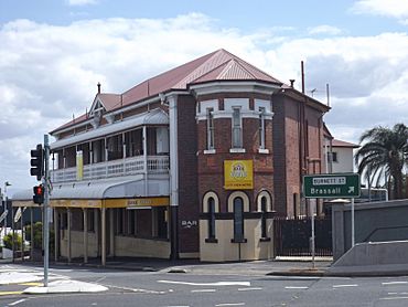
City View Hotel, 2015
|
|||||||||||||||
| Population | 512 (2021 census) | ||||||||||||||
| • Density | 730/km2 (1,900/sq mi) | ||||||||||||||
| Postcode(s) | 4305 | ||||||||||||||
| Area | 0.7 km2 (0.3 sq mi) | ||||||||||||||
| Time zone | AEST (UTC+10:00) | ||||||||||||||
| Location |
|
||||||||||||||
| LGA(s) | City of Ipswich | ||||||||||||||
| State electorate(s) | Ipswich | ||||||||||||||
| Federal Division(s) | Blair | ||||||||||||||
|
|||||||||||||||
West Ipswich is a suburb of Ipswich in Queensland, Australia. It is part of the City of Ipswich. In 2021, about 512 people lived here.
Contents
Where is West Ipswich?
This suburb is bordered by the Bremer River and Deebing Creek to the south and west. The main railway line runs along part of its northern edge.
A Look at History
West Ipswich was once known as Little Ipswich. People started settling here in the 1840s. Many important places, like the Brisbane Street shopping area and the showground, were once part of Little Ipswich. In 1991, these areas became part of the central Ipswich suburb. West Ipswich still has many old buildings from the 1900s.
Schools in the Past
Little Ipswich State School first opened on August 1, 1861. Its first headmaster was William O'Donnell. Later, the school's name changed to Ipswich West State School.
On September 17, 1883, the school split into two: Ipswich West Boys State School and Ipswich West Girls and Infants State School. Then, on January 1, 1934, the two schools joined back together. They became one school again, called Ipswich West State School.
Ipswich West Opportunity School opened in 1973 with Kevin Morris as its principal. In January 1979, its name changed to Ipswich West Special School.
The Old Railway Station
The Little Ipswich railway station was a train stop for many years. It was part of the Dugandan railway line from 1882 to 1964. Even after most of the Dugandan line closed, it stayed open for the Churchill railway line. You could find it on the corner of Pound and Keogh Streets.
Who Lives Here?
The number of people living in West Ipswich has grown a little over time. In 2016, there were 494 people living here. By 2021, the population had increased to 512 people.
Old Buildings and Places

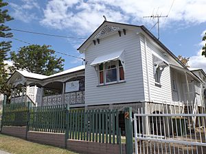
West Ipswich has several places that are listed for their historical importance. These are called heritage-listed sites. They include:
- 277 Brisbane Street: City View Hotel
- 1 Burnett Street: William Berry residence
- 2 Burnett Street: Idavine
- 6 Burnett Street: Notnel
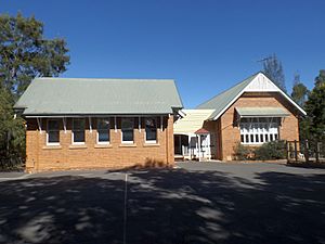
- 12 Omar Street: Ipswich West State School
Education in West Ipswich
Ipswich West State School
Ipswich West State School is a government primary school. It teaches students from Prep to Year 6. Both boys and girls attend this school. You can find it at 12 Omar Street, which is on the corner of Keogh Street. In 2018, the school had 241 students.
Ipswich West Special School
Ipswich West Special School is a special school for students from Prep to Year 12. It also teaches both boys and girls. Its entrance is on Tiger Street, though it shares the 12 Omar Street address. In 2018, 88 students were enrolled here.
Nearby High Schools
West Ipswich does not have its own mainstream high schools. Students usually go to nearby schools like Bremer State High School in Ipswich CBD or Ipswich State High School in Brassall.
Fun Things to Do
Willey Street Park has a cool BMX track. The Ipswich and West Moreton BMX Club uses this track for riding.
 | Kyle Baker |
 | Joseph Yoakum |
 | Laura Wheeler Waring |
 | Henry Ossawa Tanner |


