
Westport, New Zealand facts for kids
Quick facts for kids
Westport
Kawatiri (Māori)
|
|
|---|---|
 |
|
| Country | New Zealand |
| Region | West Coast |
| District | Buller District |
| Ward | Westport |
| Electorates |
|
| Area | |
| • Total | 11.53 km2 (4.45 sq mi) |
| Population
(June 2023)
|
|
| • Total | 4,250 |
| • Density | 368.6/km2 (954.7/sq mi) |
Westport is a town located on the West Coast of New Zealand's South Island. Its Māori name is Kawatiri. It was founded in 1861, making it the oldest European settlement in the area.
Westport sits on the right bank of the Buller River, right where it meets the sea. It is also near Cape Foulwind, a well-known headland. The town is connected to Greymouth (about 100 km south) and Nelson (about 222 km northeast) by State Highway 6. In 2018, about 4,389 people lived in Westport.
Contents
- What's in a Name? The Story of Westport
- A Look Back: The History of Westport
- Westport's Climate and Weather
- How Many People Live in Westport?
- What Drives Westport's Economy?
- News and Radio in Westport
- Fun Things to Do: Tourism in Westport
- Getting Around: Transport in Westport
- What Facilities Does Westport Have?
- Learning in Westport: Schools and Education
- Famous People from Westport
- Notable Buildings in Westport
- Images for kids
- See also
What's in a Name? The Story of Westport
The Māori name for the river and the region is Kawatiri. This name means "deep and swift," which describes the river well.
People believe the town was named after Westport in County Mayo, Ireland. Its location on the west coast also likely influenced the name.
A Look Back: The History of Westport
People have lived near Westport for a very long time. Archaeologists found proof that Māori lived close to the Buller River mouth as early as the 14th century. Māori mainly lived along the coast. They also explored the mountains to find pounamu (greenstone or jade). This valuable stone was then traded with other iwi (tribes).
Early European Settlers and Gold
The first European settlers arrived in Westport in 1861. They came looking for gold. The first European ship to enter the river was the Three Brothers in 1844. Other ships looking for seals were in the Cape Foulwind area even earlier, in the 1820s.
In the 1880s, many geologists and surveyors explored the area. They searched for valuable resources and mapped the land. Famous explorers like Charles Heaphy, William Fox, and Thomas Brunner were among them.
Gold first attracted people to Westport. Large areas near the coast were dug up to find the precious metal. However, the region soon became much more famous for coal mining. Coal mining is still an important industry in the area today.

The Rise of Coal Mining
A company called the Westport Colliery Company Ltd started in 1878. It became The Westport Coal Company in 1881. This happened when a group of businessmen from Dunedin bought the mines.
The main coal fields were at Coalbrookdale (Denniston) and Granity Creek (Millerton). Coal was taken to Westport harbour and then shipped out. By 1905, The Westport Coal Company was the biggest coal producer in New Zealand.
Westport was part of the Nelson Province from 1853 to 1876.
Earthquakes and New Buildings
Westport has been hit by several earthquakes. The worst was the 1929 Murchison earthquake. During this earthquake, many buildings fell down, including the post office tower. After the earthquake, many new buildings were constructed in the Art Deco style. The Clock Tower Chambers is a good example of these buildings.
_-Palmerston_Street,_Westport._New_Zealand_post_card,_issued_by_G_Parkhouse,_Westport._Phototyped_in_Saxony_(ca_1910)_(21453604688).jpg)
Dealing with Floods
Westport and the Buller District have experienced many floods since 1846. In January 1868, heavy rain caused floods that destroyed two wharves. The town flooded again in October and November 1926. More floods happened in 1970, 2012, and 2015.
In 2018, Cyclone Fehi damaged Westport. Experts say Westport is in an area prone to flooding. Climate change is also causing water levels to rise. Local councils are worried about not having enough money for flood protection.
Recent Major Floods
In July 2021, very wet weather across New Zealand caused more flooding. About 2,000 people, which is half of Westport's residents, had to leave their homes. The flood caused millions of dollars in damage. Hundreds of homes were affected. About 563 homes were damaged. Many of these homes needed major repairs or were unsafe to live in. By October 2021, 450 homes were still damaged or could not be lived in.
In February 2022, Westport had more heavy rain and serious flooding. Homes, farms, and roads were damaged. Residents had to be evacuated again. A state of emergency was declared in the Buller District. Government officials described this flood as "one of the worst." They also linked it to climate change. The Prime Minister announced a special fund to help farmers with flood damage.
In July 2022, reports showed that over 400 homes in Westport still had not been fully repaired. Local councils have asked for NZ$54 million. This money would be used to build flood walls. It would also help people move from flood-prone areas. And it would improve Westport's stormwater system.
Westport's Climate and Weather
Westport's weather is greatly affected by the Tasman Sea. This means it gets a lot of rain throughout the year. Even with high rainfall, Westport can sometimes have droughts. Water saving measures are sometimes needed. The temperatures in Westport do not change much throughout the year. It is generally colder than northern New Zealand.
| Climate data for Westport Airport (1991–2020 normals, extremes 1937–present) | |||||||||||||
|---|---|---|---|---|---|---|---|---|---|---|---|---|---|
| Month | Jan | Feb | Mar | Apr | May | Jun | Jul | Aug | Sep | Oct | Nov | Dec | Year |
| Record high °C (°F) | 29.1 (84.4) |
29.2 (84.6) |
28.6 (83.5) |
28.4 (83.1) |
25.0 (77.0) |
20.3 (68.5) |
18.0 (64.4) |
19.3 (66.7) |
22.0 (71.6) |
22.7 (72.9) |
25.7 (78.3) |
27.3 (81.1) |
29.2 (84.6) |
| Mean maximum °C (°F) | 23.7 (74.7) |
24.2 (75.6) |
23.1 (73.6) |
21.0 (69.8) |
18.9 (66.0) |
16.4 (61.5) |
15.9 (60.6) |
15.9 (60.6) |
17.5 (63.5) |
18.5 (65.3) |
20.3 (68.5) |
22.0 (71.6) |
25.1 (77.2) |
| Mean daily maximum °C (°F) | 20.2 (68.4) |
20.7 (69.3) |
19.8 (67.6) |
17.5 (63.5) |
15.5 (59.9) |
13.7 (56.7) |
12.9 (55.2) |
13.4 (56.1) |
14.5 (58.1) |
15.4 (59.7) |
16.9 (62.4) |
18.7 (65.7) |
16.6 (61.9) |
| Daily mean °C (°F) | 16.4 (61.5) |
16.8 (62.2) |
15.8 (60.4) |
13.6 (56.5) |
11.7 (53.1) |
9.8 (49.6) |
8.9 (48.0) |
9.5 (49.1) |
10.7 (51.3) |
11.8 (53.2) |
13.1 (55.6) |
15.2 (59.4) |
12.8 (55.0) |
| Mean daily minimum °C (°F) | 12.6 (54.7) |
12.9 (55.2) |
11.8 (53.2) |
9.7 (49.5) |
7.8 (46.0) |
5.9 (42.6) |
4.9 (40.8) |
5.6 (42.1) |
7.0 (44.6) |
8.2 (46.8) |
9.4 (48.9) |
11.6 (52.9) |
9.0 (48.2) |
| Mean minimum °C (°F) | 8.2 (46.8) |
8.6 (47.5) |
7.1 (44.8) |
4.9 (40.8) |
2.7 (36.9) |
1.1 (34.0) |
0.8 (33.4) |
1.1 (34.0) |
2.3 (36.1) |
3.6 (38.5) |
5.0 (41.0) |
7.1 (44.8) |
−0.3 (31.5) |
| Record low °C (°F) | 4.7 (40.5) |
2.9 (37.2) |
1.0 (33.8) |
0.7 (33.3) |
−2.5 (27.5) |
−3.5 (25.7) |
−1.5 (29.3) |
−2.5 (27.5) |
−1.8 (28.8) |
−0.6 (30.9) |
0.5 (32.9) |
3.7 (38.7) |
−3.5 (25.7) |
| Average rainfall mm (inches) | 163.4 (6.43) |
121.4 (4.78) |
143.1 (5.63) |
163.8 (6.45) |
186.5 (7.34) |
199.5 (7.85) |
170.1 (6.70) |
187.0 (7.36) |
182.6 (7.19) |
202.2 (7.96) |
157.3 (6.19) |
196.9 (7.75) |
2,073.8 (81.63) |
| Average rainy days (≥ 1.0 mm) | 12.0 | 10.4 | 11.6 | 12.3 | 15.3 | 16.4 | 14.1 | 15.7 | 17.0 | 17.9 | 14.6 | 14.9 | 172.2 |
| Average relative humidity (%) | 83.3 | 86.4 | 86.7 | 85.8 | 87.7 | 86.6 | 84.3 | 85.2 | 82.7 | 84.6 | 80.3 | 82.4 | 84.7 |
| Mean monthly sunshine hours | 213.0 | 174.9 | 164.2 | 151.5 | 114.7 | 93.4 | 120.7 | 118.6 | 138.9 | 158.4 | 171.7 | 179.4 | 1,799.4 |
| Source 1: NIWA Climate Data | |||||||||||||
| Source 2: CliFlo | |||||||||||||
How Many People Live in Westport?
Westport covers about 11.53 square kilometers. As of 2018, the estimated population was 4,389 people. This means there were about 381 people per square kilometer.
In the 2018 New Zealand census, Westport had 4,389 residents. This was a small decrease from 2013 and 2006. There were 1,998 households in the town. The population was almost evenly split between males and females. About 16.6% of residents were under 15 years old. Many people were aged 30 to 64 (43.5%), and about 24.9% were 65 or older.
Most people in Westport are of European descent (91.9%). About 12.1% are Māori. Smaller groups include Pasifika (1.8%), Asian (2.7%), and other ethnicities. About 9.2% of people were born outside New Zealand.
When asked about religion, 56.3% said they had no religion. About 33.6% were Christian. Small numbers followed Māori religious beliefs, Hinduism, Islam, Buddhism, or other religions.
About 8.3% of people aged 15 or older had a university degree. However, 32.2% had no formal qualifications. About 9.6% earned over $70,000 a year. Many people were employed full-time (38.2%) or part-time (15.3%). About 4.3% were unemployed.
| Name | Area (km2) |
Population | Density (per km2) |
Households | Median age | Median income |
|---|---|---|---|---|---|---|
| Westport North | 8.66 | 1,893 | 219 | 858 | 48.1 years | $21,500 |
| Westport South | 2.87 | 2,496 | 840 | 1,140 | 47.5 years | $23,100 |
| New Zealand | 37.4 years | $31,800 |
Westport's Rural Areas
The rural area around Westport includes Carters Beach. It covers about 90.06 square kilometers. As of 2023, its estimated population was 1,440 people.
In 2018, the rural area had 1,260 people. This was an increase from previous years. There were 498 households. The median age was 50.1 years. About 19.8% of residents were under 15.
Most people in Westport Rural are European (94.0%). About 8.8% are Māori. Other groups include Pasifika (0.7%), Asian (1.7%), and other ethnicities. About 9.0% of people were born overseas.
About 55.7% had no religion, and 32.9% were Christian. About 12.8% had a university degree. The median income was $24,900. About 43.6% of people aged 15 or older worked full-time.
What Drives Westport's Economy?
Westport's economy relies on fishing, coal mining, and dairy farming. In the past, gold mining was a huge industry. Coal mining was also much bigger, with more people working in it.

Today, the region is home to New Zealand's largest opencast mining operation in Stockton. Some native forest logging also happened in the area until around 1999.
The Holcim company had a large cement plant in Westport. It closed on June 30, 2016.
Westport is also home to EPIC Westport. This is a special place for new ideas and businesses. It hosts software developers and new startup companies.
News and Radio in Westport
Westport has its own daily local newspaper, the Westport News. The Westport News building also houses Coast FM. This is a local radio station that broadcasts across the West Coast.
Fun Things to Do: Tourism in Westport
Westport offers many attractions for visitors. These include Cape Foulwind and Tauranga Bay. Tauranga Bay has a large fur seal colony, which is fun to watch. There are also great surfing beaches.
The Old Ghost Road is a popular trail for mountain bikers. It runs between Lyell and Seddonville, north of Westport. This trail has brought many mountain bikers to the area.
The Kawatiri Coastal Trail is a new project. It will connect Westport, Carters Beach, Cape Foulwind, and Charleston. The first part of the trail, from Westport to Carters Beach, opened in December 2020.
You can also go rafting and jetboating in the Buller Gorge. Westport is a good starting point for trips to Karamea and the Oparara Basin Arches. The only road to this area goes north from Westport. Paparoa National Park is also close by.
Getting Around: Transport in Westport
Westport is served by State Highway 67. There is also a shorter road, State Highway 67A. This road goes to Carters Beach and Cape Foulwind. It ends at the old Holcim cement plant.

The Holcim company used to manage Westport's port. They used it to ship their cement products. For example, they sent cement to the Port of Onehunga in Auckland.
The first railway in the area opened in 1864. It ran from Westport for 18 km to the coal fields. The first part of the railway, from Westport to Fairdown, opened in 1875. This line eventually reached Seddonville in 1895. It was called the Seddonville Branch.
Over time, more railway lines were built. But these lines were not connected to the main national railway network until 1942. This happened when the Stillwater–Westport Line through the Buller Gorge was finished.
Westport Airport is a small airport. It used to have flights from Air New Zealand to Wellington. Before that, there were also flights to Christchurch and Hokitika. Air New Zealand stopped its Wellington service in April 2015. Now, Sounds Air provides flights instead.
What Facilities Does Westport Have?
Westport used to have one cinema and theatre called the St James Theatre. It could seat 424 people for movies or shows. However, the theatre was found to be unsafe and had to be torn down.
A new theatre has since opened. The NBS theatre has two movie screens. One seats 55 people, and a smaller one seats about 20. This theatre also has a large hall with seating for about 370 people and a stage for performances.
The town also has an 18-hole golf course. It is about 5600 meters long. The course has narrow fairways and small greens.
The Pulse Energy Recreation Centre is a sports complex. It opened on April 18, 2009.
Te Taha o Te Awa Marae is a special meeting place in Westport. It belongs to Ngāti Apa ki te Rā Tō and its Pūaha Te Rangi hapū (sub-tribe). It includes a wharenui (meeting house), also called Te Taha o te Awa.
The Coaltown Museum opened in 2013. It shows the local history of the area.
The Sue Thomson Casey Memorial Library is Westport's public library. It is located on Palmerston Street.
Learning in Westport: Schools and Education
.jpg)
Buller High School is a secondary school for students in years 9–13. It has about 301 students. The school celebrated its 75th anniversary in 1997. However, it also says it has been open for over 100 years. This is because it is connected to older secondary schools in the area.
Westport North School and Westport South School are primary schools. They teach students from years 1–8. Westport North has about 3235 students, and Westport South has about 3236 students. Both schools were founded in the early 1940s.
St Canice's School is also a primary school for years 1–8. It is a Catholic school that has been operating since at least 1882. It has about 3220 students.
All these schools are coeducational, meaning both boys and girls attend.
Famous People from Westport

- Marlene J Bennetts – a poet and author of children's books.
- Ben Blair – a rugby union player.
- James Colvin – a politician.
- G. F. J. Dart – an educator and playwright.
- Alan Deere – a World War II fighter pilot ace.
- Anna Harrison – a netball player.
- Peter Hawes – a playwright, author, and actor.
- Laura Suisted – a journalist.
Notable Buildings in Westport
-
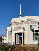
Westport Post Office
-
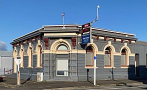
Former Bank of New Zealand building, now home to the Westport News
-
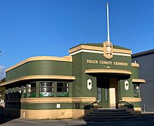
Buller County Chambers


Images for kids
-
The Holcim cement plant was a large factor in the local economy.

See also
 In Spanish: Westport (Nueva Zelanda) para niños
