Tinton Falls, New Jersey facts for kids
Quick facts for kids
Tinton Falls, New Jersey
|
||
|---|---|---|
|
Borough
|
||
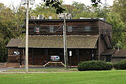
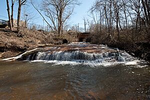
Old Mill at Tinton Falls
|
||
|
||
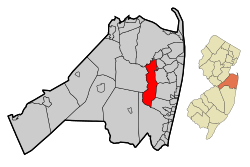
Map of Tinton Falls in Monmouth County. Inset: Location of Monmouth County highlighted in the State of New Jersey.
|
||
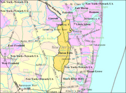
Census Bureau map of Tinton Falls, New Jersey
|
||
| Country | ||
| State | ||
| County | Monmouth | |
| Incorporated | August 15, 1950 as New Shrewsbury | |
| Renamed | 1975 as Tinton Falls | |
| Government | ||
| • Type | Faulkner Act (mayor–council) | |
| • Body | Borough Council | |
| Area | ||
| • Total | 15.61 sq mi (40.42 km2) | |
| • Land | 15.48 sq mi (40.08 km2) | |
| • Water | 0.13 sq mi (0.33 km2) 0.83% | |
| Area rank | 173rd of 565 in state 12th of 53 in county |
|
| Elevation | 98 ft (30 m) | |
| Population
(2020)
|
||
| • Total | 19,181 | |
| • Estimate
(2023)
|
19,354 | |
| • Rank | 144th of 565 in state 12th of 53 in county |
|
| • Density | 1,239.5/sq mi (478.6/km2) | |
| • Density rank | 357th of 565 in state 44th of 53 in county |
|
| Time zone | UTC−05:00 (Eastern (EST)) | |
| • Summer (DST) | UTC−04:00 (Eastern (EDT)) | |
| ZIP Codes | ||
| Area code(s) | 732 | |
| FIPS code | 3402573020 | |
| GNIS feature ID | 0885419 | |
Tinton Falls is a borough in Monmouth County, New Jersey. It is located in the Jersey Shore area. The borough is a business center and a bedroom suburb for New York City. In 2020, about 19,181 people lived here. This was an increase from 17,892 people in 2010.
The borough was first called New Shrewsbury. It was formed on August 15, 1950. This happened after it separated from Shrewsbury Township. In 1975, its name changed to "Tinton Falls." This new name helped avoid mail mix-ups. The name comes from Tinton Manor, a plantation owned by Lewis Morris. This area was one of New Jersey's first busy mill towns. Tinton Falls is also home to the tallest waterfall on New Jersey's coastal plain. This waterfall once powered the old mill.
Contents
History of Tinton Falls
The area of Tinton Falls was first settled by Europeans in the late 1600s. This likely began with land purchases from the Lenni Lenape Native Americans in 1664. Water power and iron ore were important reasons for people to settle here. Soon after the land was bought, James Grover built an ironworks along the river. Grover was probably the founder of the community. In the 1600s, it was called "New Shrewsbury." Back then, the waterfall was about 30 feet (9.1 m) high. Over time, erosion and a broken dam made it smaller.
The Early Ironworks
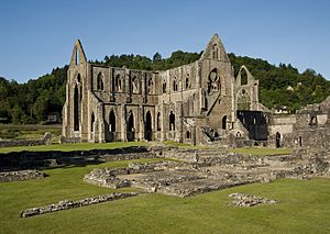
Grover's ironworks was a very important part of the community. It was one of the oldest ironworks built in the country. Only a few in Jamestown and Massachusetts were older. In 1675, Colonel Lewis Morris bought half of the ironworks company. He also got land along the Shrewsbury River. Morris bought more land from Bartholomew Applegate, who had a corn mill. Morris named his land "Tintern Manor," after his family's lands in Great Britain. Many believe Tintern Abbey in Wales is the inspiration for the name Tinton Falls.
In 1691, Colonel Morris passed away. He left the ironworks and Tinton Manor to his nephew, also named Lewis Morris. By 1714, the ironworks was not as profitable. However, it was still mentioned as late as 1844. Morris brought many African slaves to mine the iron ore. This led to the area being called the "Iron Plantation." At that time, Tinton Falls had the most slaves in the New Jersey colony. Later, in the mid-1700s, it had the largest number of freed slaves in the 13 colonies. This was because people followed the ideas of abolitionist John Woolman.
Becoming a Separate Borough
In 1693, Tinton Manor and nearby lands became part of Shrewsbury Township. This township covered a large area of eastern Monmouth County. Over the years, many new towns were created, making Shrewsbury Township smaller. In 1926, the borough of Shrewsbury was formed. In July 1950, Tinton Falls and Wayside left Shrewsbury Township. They renamed themselves the Borough of New Shrewsbury. To avoid confusion with the nearby Shrewsbury borough and township, residents voted in 1975 to change the name to "The Borough of Tinton Falls."
Geography and Location
Tinton Falls covers about 15.60 square miles (40.41 km2). Most of this is land, with a small amount of water.
Some smaller communities and places within Tinton Falls include Wayside, Green Grove, Hockhockson, Macedonia, Pine Brook, Reevytown, West Shrewsbury, and Wileys Corner.
The borough shares borders with several other towns in Monmouth County. These include Colts Neck Township, Eatontown, Middletown Township, Neptune Township, Ocean Township, Red Bank, Shrewsbury, Shrewsbury Township, and Wall Township.
Population and People
| Historical population | |||
|---|---|---|---|
| Census | Pop. | %± | |
| 1950 | 3,783 | — | |
| 1960 | 7,313 | 93.3% | |
| 1970 | 8,395 | 14.8% | |
| 1980 | 7,740 | −7.8% | |
| 1990 | 12,361 | 59.7% | |
| 2000 | 15,053 | 21.8% | |
| 2010 | 17,892 | 18.9% | |
| 2020 | 19,181 | 7.2% | |
| 2023 (est.) | 19,354 | 8.2% | |
| Population sources: 1950–2000 2000 2010 2020 |
|||
Population in 2010
In 2010, Tinton Falls had 17,892 people living in 8,355 households. About 82.4% of the people were White, 9.3% were Black or African American, and 4.7% were Asian. About 6.3% of the population was Hispanic or Latino.
The average age of people in Tinton Falls was 46.9 years. About 19% of the population was under 18 years old. About 25.6% were 65 years or older.
The average household income in 2010 was about $78,894. The average family income was about $99,231. About 4.1% of the population lived below the poverty line.
Economy and Businesses
Tinton Falls has several important businesses and attractions.
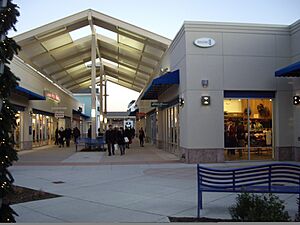
- Jersey Shore Premium Outlets: This outdoor shopping mall opened in 2008. It has 120 outlet stores and a food court.
- Tinton Falls Solar Farm: This large solar power plant covers 170 acres (69 ha). It has 85,000 solar panels. When it was built, it was one of the biggest solar farms in the Northeast United States.
- Commvault Systems: This company, founded in 1996, makes software for managing computer data. Its main headquarters are in Tinton Falls.
Parks and Fun Activities
Tinton Falls offers several places for outdoor fun.
- Overlook by the Falls: This is a wildlife area near the town's waterfalls. Visitors can walk on trails to see the falls and local animals.
- Borough Parks: Tinton Falls has many parks. Hockhockson Park has baseball fields and basketball courts. Liberty II Park has football fields, a softball field, and basketball courts. Riverdale West Park has soccer fields and a basketball court. The Sycamore Recreation Complex offers six lighted multi-purpose fields.
- Shark River Park: This large park covers 961 acres (389 ha) along the Shark River. It was the first park included in the Monmouth County Park System in 1961.
Local Government
Tinton Falls uses a Mayor-Council form of government. This means there is a mayor and a borough council. The mayor is the main leader and is elected for a four-year term. The borough council has five members. They are elected for four-year terms, with some seats up for election every two years.
As of July 2025, the mayor's position is vacant. The current members of the Borough Council are Council President Risa Clay (term ends 2027), Deputy Council President Lawrence A. Dobrin (2025), Greg Alessi (2025), Tracy A. Buckley (2027), and Michael J. Nesci (2027).
Former Mayor Vito Perillo passed away on February 22, 2025. He was known as "America's Oldest Mayor" because he was elected for his second term at 97 years old.
Historic District
The Tinton Falls Historic District is an important area. It is located where Tinton and Sycamore Avenues meet. This district was added to the National Register of Historic Places in 1977. It is important for its history in archaeology, industry, military, and politics.
Education in Tinton Falls
Students in Tinton Falls attend public schools from kindergarten through eighth grade. They go to schools in the Tinton Falls School District. Students from Shrewsbury Township and military families from Naval Weapons Station Earle also attend these schools. The district has three schools:
- Mahala F. Atchison Elementary School (grades K–3)
- Swimming River Elementary School (grades 4–5)
- Tinton Falls Middle School (grades 6–8)
For high school, students attend Monmouth Regional High School. This school is located in Tinton Falls. It also serves students from Eatontown and Naval Weapons Station Earle.
Students can also apply to special magnet schools in the Monmouth County Vocational School District. These include schools focused on science, health, technology, biotechnology, and communications.
There are also private schools in the area. Ranney School is a K–12 private school. Trinity Hall is an all-girls high school.
Transportation and Travel
Tinton Falls has many roads and highways. Major highways include the Garden State Parkway, Route 18, Route 33, and Route 66. The Garden State Parkway has several exits in Tinton Falls.
Public Transportation
- Bus: The Academy Bus Line offers service from the Garden State Parkway to Lower Manhattan in New York City. NJ Transit also has local bus routes (836 and 838).
- Train: NJ Transit provides passenger train service at the Red Bank station. This is on the North Jersey Coast Line. Trains go to places like Hoboken Terminal and New York Penn Station.
- Airports: Monmouth Executive Airport is nearby for private jets. The closest major airport is Newark Liberty International Airport in Newark. It is about 30 miles (48 km) north of Tinton Falls.
Points of Interest
- Old Mill at Tinton Falls: This mill was built in 1676. It was added to the National Register of Historic Places in 1973.
- Tinton Falls Library: This library is part of the Monmouth County Library System. It was first established in 1961 and changed its name in 1975. The library reopened in November 2024 after being closed for repairs.
Notable People
Many interesting people have lived in or are connected to Tinton Falls. Some of them include:
- Bryan Antoine (born 2000), a college basketball player.
- Kelly J. Breen (born 1969), a trainer of racehorses.
- Ernabel Demillo (born 1965), a television journalist.
- Alan Garcia (born 1985), a horse racing jockey.
- Milton Goode (born 1960), a retired high jumper who competed in the 1984 Olympics.
- Brianne Reed (born 1994), a soccer player.
- Ranya Senhaji (born 2002), a soccer player for the Morocco women's national team.
- Quentin Wheeler (born 1955), a track and field athlete who competed in the 1976 Olympics.
- Dorothy Young (1907–2011), an entertainer and assistant to magician Harry Houdini.
See also
 In Spanish: Tinton Falls para niños
 | Laphonza Butler |
 | Daisy Bates |
 | Elizabeth Piper Ensley |


