
Woodside, Utah facts for kids
Quick facts for kids
Woodside, Utah
|
|
|---|---|

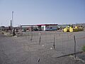
The roadside filling station at Woodside
|
|

Woodside, Utah
Location in Utah

Woodside, Utah
Location in the United States
|
|
| Country | United States |
| State | Utah |
| County | Emery |
| Established | 1881 |
| Abandoned | c. 1970 |
| Elevation | 4,642 ft (1,415 m) |
| GNIS feature ID | 1437726 |
Woodside is a ghost town in Emery County, Utah. A ghost town is a place where most people have left, leaving behind empty buildings. Woodside is located on the west bank of the Price River. Today, a fenced-in filling station is one of the few signs that people once lived here. It sits along a quiet stretch of U.S. Route 6/191 between Wellington and Green River.
Contents
The Early Days of Woodside
Woodside began in 1881 when the Denver and Rio Grande Western Railroad built a bridge and a place for trains to get water. The first person to live here was a prospector named Henry H. Hutchinson. A prospector is someone who searches for valuable minerals.
More settlers arrived the next year. They started digging an irrigation canal to bring water to their farms. An irrigation canal is a ditch that carries water from a river to fields. These settlers were drawn to the area because of the good water supply and many cottonwood trees. They called their new settlement Lower Crossing.
As the town grew, it added stores and a blacksmith shop. A blacksmith is a person who makes and repairs things made of iron. The town was then renamed "Woodside" because of all the cottonwood groves.
Challenges and Growth
The Price River was a big challenge for Woodside. Before a dam called Scofield Reservoir was built, the river's water level changed a lot. It would be very high at some times and almost dry at others. Also, heavy rains far away could cause sudden and dangerous flash floods in Woodside.
Despite these problems, the town kept growing. A hotel and places to keep livestock were built near the railroad station. Woodside became a place where nearby ranches could get supplies. A schoolhouse built in 1892 was also used as a meeting place for the town.
In 1897, a famous outlaw named Butch Cassidy reportedly hid in tunnels under a house outside Woodside.
Population Changes
In 1900, Woodside had 114 people. By 1910, the population had grown to 328. The town had schools, saloons (places to drink), and a large hotel. However, by 1920, the population had dropped slightly to 300.
Decline of the Town
In the late 1920s, the railroad moved many of its operations to Helper. This meant Woodside lost its livestock shipping and railroad station. This was a big problem for the town.
Then, in the 1930s, severe droughts hit the area. A drought is a long period of very little rain. By 1940, the population of Woodside had fallen to just 30 people.
Woodside's Unique Features
In the 1940s, Woodside became a small tourist spot. The railroad had dug a large water well in the 1880s. This well later turned into a cold, bubbling mudpot. This mudpot was caused by natural carbon dioxide gas pushing water and mud up. It was developed into a cold water geyser, along with a filling station, store, and cafe.
In 1924, a company drilled a well near Woodside. They did not find oil, but they found a large amount of helium-rich gas. Helium is a very light gas used in balloons and for scientific research. Because of this discovery, President Calvin Coolidge set aside the "Woodside Dome Field" as "United States Helium Reserve #1." This means the government protected the area as a source of helium. Even though it has not been used yet, it is still a large source of helium.
In the 1960s, a law called the Highway Beautification Act led to the removal of many billboards. These billboards had advertised Woodside's geyser along U.S. Route 6. This greatly reduced the number of tourists visiting the town. Around 1970, the cafe and store burned down. Today, only the geyser and the filling station remain. The geyser used to shoot water as high as 75 feet, but it is much lower now.
A scene from the 1991 movie Thelma & Louise was filmed in Woodside. In the early 1990s, Roy Pogue bought the townsite. In 2012, he decided to sell it.
Climate
Woodside has a semi-arid climate. This means it is a dry place, usually with hot summers and cold winters, and not much rain or snow.
Images for kids
-
The roadside filling station at Woodside
