Zaranj facts for kids
Quick facts for kids
Zaranj
زرنج
Zarange
|
|
|---|---|

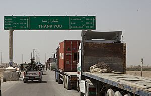
The Abresham, also known as Silk Bridge, border crossing in 2011
|
|
| Country | |
| Province | Nimruz Province |
| District | Zaranj District |
| Elevation | 476 m (1,562 ft) |
| Population
(2015)
|
|
| • City | 49,851 |
| • Urban | 160,902 |
| Time zone | UTC+4:30 |
Zaranj is a city in southwestern Afghanistan. About 160,902 people lived there in 2015. It is the main city of Nimruz Province. Zaranj is connected by roads to other important cities like Lashkargah, Kandahar, and Farah. It is also linked to the Iranian city of Zabol to the west.
The Abresham border crossing is west of Zaranj, right on the border between Afghanistan and Iran. This crossing is one of three key trade routes. These routes connect Central Asia, East Asia, and South Asia with the Middle East. Zaranj Airport is about 13 miles (21 km) east of the city.
Zaranj has a very long history, going back over 2500 years. A famous leader named Ya'qub ibn al-Layth al-Saffar, who started the Saffarid dynasty, was born in this ancient place.
Contents
History of Zaranj
The modern city of Zaranj is named after an old city. This name was known as Zranka in ancient Persian. In Greek, it became Drangiana. Other old names for Zaranj include Zirra and Zarangia. The word Zaranj comes from an old Persian word meaning "waterland."
The ancient capital of Drangiana, called Zranka, was likely located at Dahan-e Gholaman in Iran. After that city was left empty, its name, Zarang or Zaranj, was given to new main cities in the area. This region later became known as Sakastān, then Sijistan, and finally Sistan. The Zaranj from the Middle Ages is found about 4.4 km north of today's city.
Before medieval Zaranj, the capital of Sistan was at Ram Shahristan. This city got its water from the Helmand River. But its dam broke, and the area lost its water. So, people moved three days' walk away to start a new city, which became Zaranj. This old Zaranj is even shown on an ancient map called the Peutinger Map.
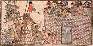
The area came under Muslim rule in 652. Zaranj gave up to the governor of Greater Khorasan. It then became a base for more expansion in the region. In 661, a small Arab army took control again after losing it for a short time. Records show a Christian community in Zaranj in the 500s. By the late 700s, there was a Christian church district there.
In the 800s, Zaranj was the capital of the Saffarid dynasty. The founder was a local metalworker who became a military leader, Ya'qub ibn al-Layth al-Saffar. Zaranj later became part of other empires, including the Ghaznavids, Ghorids, Timurids, and Safavids. After being defeated in 900, the Saffarids became less powerful. They were then conquered by Mahmud of Ghazni in 1003. After that, Zaranj was the capital for the Nasrid and Mihrabānid rulers of Nīmrūz.
In the early 1700s, the city became part of the Afghan Hotaki dynasty. They were removed from power in 1738 by Nader Shah. Zaranj later came under the Khanate of Kalat in the mid-1700s. Under modern Afghan governments, the area was called Farah-Chakansur Province. In 1968, it was split into Nimruz Province and Farah. The city of Zaranj became the capital of Nimroz province.
Zaranj in the 2000s
A new road, Route 606, was built between Zaranj and Delaram in Farah province. The government of India helped build this road. It cost about US$136 million. The road connects the deep-sea port at Chabahar in Iran to Afghanistan's main highway system. This highway system links cities like Kabul, Kandahar, Herat, Mazar-i-Sharif, and Kunduz.
The 215 km (134 mi) long highway was given to Afghan officials in 2009. Some groups did not want the road built. They caused problems for the construction workers.
Nimruz province has been one of the areas where the Taliban group has been active.
Because Zaranj is close to Iran, the city mostly uses products from Iran. The economy for people living in Zaranj is getting better. Many trucks carrying goods from the Middle East come into the city every day.
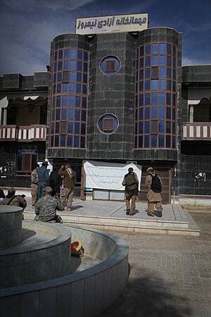
In the last ten years, the U.S. Marines and other international forces have visited Zaranj. U.S. officials have worked with the Afghan government on big development projects. These projects include improving the city's water system. They also built barracks for the Afghan military and Afghan National Police, as well as a hospital and a school.
The city is served by Zaranj Airport. The United States has also helped improve this airport. U.S. Marines built two concrete landing areas for helicopters. These areas now help all helicopters land at Zaranj airport.
Taliban Takes Control
On August 6, 2021, local sources confirmed that the city was taken over by the Taliban. This made Zaranj the first provincial capital they captured during their advances in 2021. This happened after foreign forces left Afghanistan. Afghan officials said the Taliban met "little resistance" when they took the city. The Afghan National Army's 215th Corps focused on fighting in Battle of Lashkargah instead. Soon after entering the city, the Taliban broke into the city's prison. They let out many prisoners into Zaranj.
In March 2022, the New York Times reported that the business of smugglers was growing. These smugglers help Afghans cross into Iran to escape Taliban rule or hard economic times. The report said that "nearly everyone in Zaranj is involved, in one way or another, in the smuggling business." The paper described Zaranj as "lively." Newcomers buy food from street vendors and look at shops. They sit around tables, wanting to learn more about the difficult journey ahead.
Climate and Weather
Zaranj has a hot desert climate. This means it has very hot summers and cool winters. It does not rain much, and most of the rain falls in winter. Summer temperatures can reach almost 50°C (122°F). Snowfall in Zaranj is very rare. It snowed in the city on November 27, 2016.
| Climate data for Zaranj | |||||||||||||
|---|---|---|---|---|---|---|---|---|---|---|---|---|---|
| Month | Jan | Feb | Mar | Apr | May | Jun | Jul | Aug | Sep | Oct | Nov | Dec | Year |
| Record high °C (°F) | 24.1 (75.4) |
30.6 (87.1) |
37.0 (98.6) |
45.0 (113.0) |
51.0 (123.8) |
49.7 (121.5) |
49.3 (120.7) |
50.0 (122.0) |
49.7 (121.5) |
42.0 (107.6) |
36.0 (96.8) |
27.8 (82.0) |
51.0 (123.8) |
| Mean daily maximum °C (°F) | 14.3 (57.7) |
18.7 (65.7) |
25.0 (77.0) |
32.6 (90.7) |
37.3 (99.1) |
42.8 (109.0) |
42.5 (108.5) |
41.3 (106.3) |
37.0 (98.6) |
31.2 (88.2) |
23.1 (73.6) |
17.7 (63.9) |
30.3 (86.5) |
| Daily mean °C (°F) | 6.5 (43.7) |
10.0 (50.0) |
15.7 (60.3) |
23.3 (73.9) |
29.1 (84.4) |
33.4 (92.1) |
35.0 (95.0) |
32.3 (90.1) |
27.2 (81.0) |
21.9 (71.4) |
13.1 (55.6) |
8.7 (47.7) |
21.3 (70.4) |
| Mean daily minimum °C (°F) | 0.1 (32.2) |
2.9 (37.2) |
7.7 (45.9) |
14.7 (58.5) |
20.0 (68.0) |
25.2 (77.4) |
27.3 (81.1) |
24.9 (76.8) |
18.5 (65.3) |
12.3 (54.1) |
4.8 (40.6) |
0.7 (33.3) |
13.3 (55.9) |
| Record low °C (°F) | −13.2 (8.2) |
−8.2 (17.2) |
−5.2 (22.6) |
1.0 (33.8) |
5.0 (41.0) |
16.0 (60.8) |
18.4 (65.1) |
13.2 (55.8) |
3.9 (39.0) |
−2.7 (27.1) |
−7.1 (19.2) |
−8.8 (16.2) |
−13.2 (8.2) |
| Average precipitation mm (inches) | 19.7 (0.78) |
9.9 (0.39) |
11.2 (0.44) |
2.4 (0.09) |
0.6 (0.02) |
0.0 (0.0) |
0.0 (0.0) |
0.0 (0.0) |
0.0 (0.0) |
1.2 (0.05) |
1.4 (0.06) |
5.1 (0.20) |
51.5 (2.03) |
| Average rainy days | 3 | 2 | 2 | 2 | 0 | 0 | 0 | 0 | 0 | 0 | 1 | 1 | 11 |
| Average relative humidity (%) | 55 | 50 | 44 | 40 | 35 | 29 | 28 | 29 | 33 | 41 | 49 | 54 | 41 |
| Source: NOAA (1969-1983) | |||||||||||||
People of Zaranj
The population of Zaranj was about 49,851 in 2004. The main groups of people living there are:
The city of Zaranj has a population of 160,902 people. There are 17,878 homes in Zaranj. There are also 1,759 hectares of farmland. Businesses are mostly found along the main road that leads to Iran.
Important People from Zaranj
- Ya'qub ibn al-Layth al-Saffar: He started the Saffarid dynasty in Sistan. He was born near Zaranj.
- Amr ibn al-Layth: He was the second ruler of the Saffarid dynasty. He was also born near Zaranj.
- Al-Layth ibn Ali ibn al-Layth: He was a ruler of the Saffarid area in Zaranj from 909 to 910.
- Al-Mu'addal ibn al-Layth: He was a Saffarid ruler of Zaranj for part of 911.
Delaram-Zaranj Highway
The Delaram–Zaranj Highway, also known as Route 606, is a 217-kilometer (135-mile) long road. India built this two-lane road in Afghanistan. It connects Delaram in Farah Province with Zaranj in Nimruz Province, close to the Iranian border.
This road links the Afghan–Iranian border to the Kandahar–Herat Highway in Delaram. This means it connects to other major Afghan cities through A01. The highway also helps connect to India's planned mining work in Hajigak mining concession. Route 606 makes travel between Delaram and Zaranj much faster, from 12–14 hours down to just 2 hours. In May 2016, India and Iran agreed to connect this highway to the Port of Chabahar with train and road links.
See also
 In Spanish: Zaranj para niños
 | Emma Amos |
 | Edward Mitchell Bannister |
 | Larry D. Alexander |
 | Ernie Barnes |


