
Zeeland facts for kids
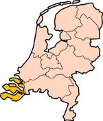


Zeeland (also known as Zealand) is a special area called a province in the Netherlands. It's located in the southwestern part of the country. Around 380,000 people call Zeeland their home.
Exploring Zeeland's Geography

Zeeland is a great example of land that has been partly taken back from the water. It sits in a large river delta, which is where several big rivers flow into the sea.
Most of Zeeland is actually below sea level. This means much of the land was once covered by the sea. People worked hard to reclaim this land. What used to be a muddy area, often covered by water at high tide, was turned into dry land.
People built small hills that stayed dry even when the tide was high. Then, they connected these hills using strong walls called dikes. This created a chain of dry land. Over time, this dry land grew bigger, giving Zeeland its shape today.
In 1953, a huge event happened: the North Sea flood of 1953. This flood covered vast amounts of land in Zeeland. After this, the people built amazing structures called the Delta Works. These protective barriers also changed how the province looked.
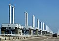
Today, Dams, tunnels, and bridges are very important for Zeeland's roads. In 2003, the Western Scheldt Tunnel opened. This tunnel was the first solid link between the two sides of the Western Scheldt river. It meant that the islands and peninsulas of Zeeland were no longer separated by water.
Zeeland's Local Areas
Here are the local areas, called municipalities, that make up Zeeland.

Borsele · Goes · Hulst · Kapelle · Middelburg · Noord-Beveland · Reimerswaal · Schouwen-Duiveland · Sluis · Terneuzen · Tholen · Veere · Vlissingen
Drenthe • Flevoland • Friesland • Gelderland • Groningen • Limburg • North Brabant • North Holland • Overijssel • South Holland • Utrecht • Zeeland
Images for kids
-
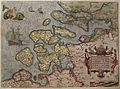
The County of Zeeland in 1580.
-
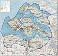
A map of Zeeland.
-
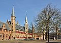
The States of Zeeland are located in a former abbey in Middelburg.
-
The Oosterscheldekering, part of the Delta Works.


See also
 In Spanish: Provincia de Zelanda para niños
