1930 San Zenón hurricane facts for kids
| Category 4 major hurricane (SSHWS/NWS) | |

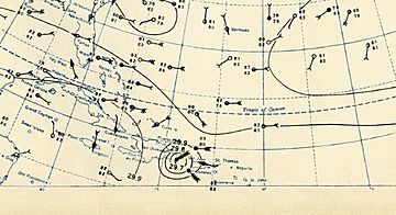
Surface weather analysis of the hurricane just before landfall in the Dominican Republic on September 3
|
|
| Formed | August 29, 1930 |
|---|---|
| Dissipated | September 17, 1930 |
| Highest winds | 1-minute sustained: 155 mph (250 km/h) |
| Lowest pressure | 933 mbar (hPa); 27.55 inHg |
| Fatalities | 2,000–8,000 |
| Damage | $50 million (1930 USD) |
| Areas affected | Dominican Republic, Haiti, Cuba, Florida, North Carolina |
| Part of the 1930 Atlantic hurricane season | |
The 1930 Dominican Republic hurricane, also called Hurricane San Zenón, was a very powerful storm. It is known as one of the deadliest Atlantic hurricanes ever recorded. This hurricane was the second big storm of the 1930 Atlantic hurricane season. People first saw it on August 29, east of the Lesser Antilles islands. It was a small but very strong Category 4 hurricane. The storm caused the deaths of up to 8,000 people when it hit the Dominican Republic.
How the Hurricane Formed and Traveled
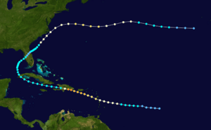
Scientists believe this storm started around August 29. It began about halfway between the Lesser Antilles and the Cape Verde islands. Some clues suggest it might have started even earlier, closer to Africa. The storm moved west and slowly got stronger.
First Sightings and Warnings
On August 31, it became a hurricane about 385 miles (620 km) east of Guadeloupe. People officially noticed the hurricane on September 1. It was passing through the Lesser Antilles and getting stronger. In Dominica, winds blew from the north, and in Barbados, they blew from the south. This showed that a storm was coming. People quickly sent warnings from Barbados to Saint Lucia. Based on more reports from ships and islands, the National Weather Bureau warned areas like Puerto Rico and Hispaniola.
Journey Through the Caribbean
After passing over or near Dominica, the hurricane entered the Caribbean Sea. Its winds were about 100 mph (160 km/h), making it a Category 2 hurricane. On September 2, the storm passed about 60 miles (95 km) southwest of Puerto Rico. It grew even stronger, becoming a major hurricane. Because the storm was small, Puerto Rico did not experience hurricane-force winds.
The hurricane kept moving slowly west-northwest, getting more powerful as it neared the Dominican Republic. A ship captain, Thomas Evans, and his crew survived being hit by the storm for seven hours. They even passed through the eye of the hurricane. He reported a very low air pressure of 933 mbar (27.55 inHg). This showed how strong the storm was. Another ship near the coast reported winds of 150 mph (240 km/h). It also helped estimate that the strongest winds were only 8 miles (13 km) from the center.
Landfall in Santo Domingo
At 2 PM on September 3, the hurricane hit land near Santo Domingo, Dominican Republic. Its center had a pressure of 933 mbar (27.55 inHg). The storm was still getting stronger when it hit. Its strongest winds were thought to be about 155 mph (250 km/h). Some even think it might have reached Category 5 strength. The worst damage happened in a 2-mile (3 km) area around where it hit.
Weakening and Later Path
The mountains of Hispaniola quickly weakened the hurricane. About 12 hours after hitting land, its winds dropped to tropical storm strength. It then moved into the Windward Passage and traveled west, south of Cuba. On September 6, the storm crossed western Cuba. It then turned northeast into the Gulf of Mexico with winds of 40 mph (65 km/h).
The storm got a little stronger again. It moved ashore near Tampa, Florida, with 45 mph (75 km/h) winds. As it crossed Florida, it weakened to a tropical depression. But it got stronger again after moving into the western Atlantic Ocean. By September 12, it was a hurricane again southeast of the Carolinas. It then brushed the Outer Banks of North Carolina with 70 mph (110 km/h) winds. The hurricane turned east and reached a second peak strength of 100 mph (160 km/h) north of Bermuda. It slowly weakened and became a tropical storm on September 16. The storm finally disappeared the next day west of the Azores islands. Its leftover parts joined another weather system.
Impact of the Hurricane
The hurricane caused damage in many places. Here's how different areas were affected:
Lesser Antilles
In Dominica, winds reached 80 to 100 mph (130 to 160 km/h). Hurricane-force winds were felt across the Lesser Antilles. The storm destroyed crops and every ship in the harbor. Two people died there. High waves also hit the coast of Saint Kitts.
Puerto Rico
In southern Puerto Rico, the winds were not as strong as hurricane force. This caused minor to moderate damage to farms. The rainfall was unusual. The most rain, over 6 inches (150 mm), fell in Cabo Rojo. But some places in the center of the southern coast got less than 1 inch (25 mm). The rain was actually helpful because the island had been very dry.
Dominican Republic: The Worst Hit
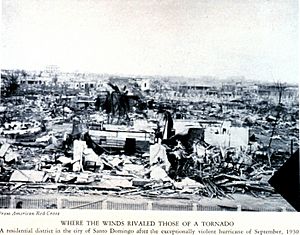
On September 3, the storm was a Category 4 hurricane when it hit Santo Domingo, the capital city of the Dominican Republic. It left a path of destruction about 20 miles (32 km) wide. Wind gusts in the city were thought to be between 150 to 200 mph (240 to 320 km/h). An instrument that measures wind, called an anemometer, recorded a gust of 180 mph (290 km/h) before it was blown away. Another observation in the capital recorded 100 mph (160 km/h) winds before the roof it was on was damaged. This was one of the strongest hurricanes ever to hit the country.
Three whole parts of the city were almost completely destroyed. One report said there was "scarcely a wreck of a wall left standing." Overall, the hurricane flattened about half of the entire city. Because the storm was small, people 75 miles (120 km) away did not even know it was coming. Heavy rain from the storm caused the Ozama River to flood. The river flowed very fast, making it impossible for boats to cross. The hurricane caused huge damage, estimated at $15 to $50 million. It was a major disaster for the area.
The Red Cross thought 2,000 people died in the city, and 8,000 more were hurt. However, the exact number of deaths may never be known. Historians believe the hurricane killed between 2,000 and 8,000 people.
Other Areas Affected
Away from the coast, the effects were minor. The mountains of Hispaniola greatly weakened the hurricane. This prevented many more deaths or much more damage. In the mountainous areas, trees were knocked down and crops were damaged. In Haiti, the hurricane brought strong winds and heavy rain. However, we don't have exact details about the damage there.
Even though the storm crossed Cuba, no damage or deaths were reported. When the storm moved through Florida, it was still very weak. The lowest air pressure in Florida was 1006 mbar (29.71 inHg) in Tampa. The hurricane then moved offshore. The National Weather Bureau issued warnings for the coasts of North Carolina and Virginia. The strongest winds stayed out at sea. Only minor damage was reported along the Outer Banks. On Cape Lookout, the hurricane knocked down 12 small buildings. It also damaged the local Coast Guard office. Power outages happened, leaving some areas on the Outer Banks without communication.
Aftermath and Recovery Efforts
Help started immediately in the Dominican Republic after the hurricane. The new President, Rafael Leónidas Trujillo, personally organized the relief work. He sent the country's entire military to help within 24 hours of the storm.
The day after the hurricane, there was a shortage of food. Many robberies also happened. The strong winds knocked out all communication within the city. So, details about the damage were unknown until some communication was fixed a day later. The newspaper La Opinión had its city office destroyed, and three staff members died. The remaining workers sent a story about the damage to their offices in New York City. They also included a plea for help. The Red Cross office in Washington, D.C., sent US$15,000 in aid a day after the hurricane hit.


