
2020 Pacific Northwest floods facts for kids

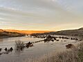
Flooding on the Walla Walla River near Touchet, Washington.
|
|
| Date | February 2020 |
|---|---|
| Location | Washington and Oregon in the United States and southwest British Columbia, Canada |
| Deaths | 1 |
The 2020 Pacific Northwest floods were big floods that hit parts of the Pacific Northwest in the United States. They mostly affected northwest Washington and areas near rivers flowing from the Blue Mountains in southeast Washington and northeast Oregon. Some parts of British Columbia, Canada, also saw flooding. These floods happened because a lot of rain fell on top of mountain snow. For some rivers, this was the worst flood ever recorded! Big rivers like the Columbia and Snake were mostly okay.
Contents
What Caused the Floods?
In early February 2020, a weather event called an atmospheric river brought huge amounts of rain to the Pacific Northwest. This rain fell on areas in Washington and northern Oregon that were at low and middle heights.
Most atmospheric rivers usually come from the southwest and move northeast. But this one was different. It moved from west to east. This direction is very good at making a lot of rain fall on the side of mountains that face the wind, like the Cascade Range. This heavy, long-lasting rain, combined with snow already on the mountains, led to widespread flooding. Some rivers saw record-breaking water levels.
Before the rain hit, the National Weather Service warned people about possible floods. In some parts of the Washington Cascades, over 15 inches (380 mm) of rain fell. The west slopes of the Blue Mountains got over 10 inches (250 mm) of rain.
Where Did the Flooding Happen?

The floods caused damage in several areas. One person sadly died during the floods.
Flooding Near the Blue Mountains
The Umatilla River rose so quickly that some people in Pendleton couldn't get warnings before they had to leave their homes. One family even had to go to their roof to escape the water. The water was so high it went over the walls built to protect the downtown area. A woman from the Pendleton area, who was believed to be trying to leave, was found a few days later.
Further downstream, the Umatilla River flooded Interstate 84. This caused a 200-mile (320 km) section of the highway to close for several days. About 50 homes in Echo were damaged. Some homes and businesses near Stanfield also saw damage. Riverfront Park near Hermiston was underwater for the second year in a row. People who were living in temporary camps nearby had to move. A mudslide also closed a railroad track owned by Union Pacific.
The Walla Walla River area also had a lot of flooding. The city of Walla Walla was mostly safe from flooding on Mill Creek. This creek was put into a deep channel through the city after a flood in 1931. However, outside the city, the creek overflowed. It washed out roads, flooded fields, and damaged buildings. To help control the water, the Army Corps of Engineers released water from Bennington Lake. This is a reservoir east of Walla Walla. The reservoir itself was not in danger, but it took about 40 days to get its water levels back to normal.
Much of Milton-Freewater was evacuated when the Walla Walla River went over a protective wall. Upstream, the river and its smaller streams made some roads in the Blue Mountains impossible to use. US 12 was closed in two places because of flooding from the Walla Walla River and the Touchet River. The Touchet River also damaged its protective walls.
Many rivers and streams flowing from the Blue Mountains broke their old flood records from the 1996 Pacific Northwest floods. Other spots came very close to those records. However, rivers on the east side of the Cascades, like the Yakima, only had minor flooding. This was because of how the 2020 atmospheric river moved and because there wasn't much snow on the valley floor.
Flooding in Northwest Washington and British Columbia
Many rivers flowing from the west side of the Cascades, north of Interstate 90, also flooded. In the north, the Sumas River went over its protective walls. This flooded the city of Sumas. It forced the closure of State Route 9 and the border crossing that connects Sumas with Abbotsford, British Columbia. People in Sumas were asked not to pump water from their homes right away because of the high water levels. North of the border, some fields were flooded. Health officials in British Columbia also shared information to calm worries about natural asbestos in the Sumas River mud.
Major flooding on the Snohomish River did not reach high enough to affect businesses in Snohomish. However, many roads near the town were covered by water. As the water went down on the Skagit River, it was found that a protective wall near Burlington was damaged and needed repairs. Strong winds in that area also caused many people to lose electricity. The Army Corps of Engineers helped prevent the Green River from flooding the Seattle suburb of Kent. They did this by controlling the water flow through the Howard Hanson Dam.
Images for kids
-
Flooding on the Walla Walla River near Touchet, Washington.
