
Muhammad al-Idrisi facts for kids
Quick facts for kids
Muhammad al-Idrisi
|
|
|---|---|
.jpg)
Statue of al-Idrisi in Ceuta
|
|
| Born | 1100 Ceuta, Almoravid dynasty (present-day Spain)
|
| Died | 1165 (aged 64–65) Ceuta, Almohad Caliphate (present-day Spain)
|
| Known for | Tabula Rogeriana |
| Scientific career | |
| Fields | Geographer, writer, scientist, cartographer |
Muhammad al-Idrisi (Arabic: أبو عبد الله محمد الإدريسي القرطبي الحسني السبتي; Latin: Dreses; 1100 – 1165) was a famous Muslim geographer and mapmaker. He was also a scientist and writer. For some time, he lived in Palermo, Sicily. He worked at the court of King Roger II.
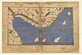
Al-Idrisi was born in Ceuta, which was then part of the Almoravid dynasty. He is best known for creating the Tabula Rogeriana. This was one of the most advanced world maps of the Middle Ages.
Contents
Early Life and Travels
Al-Idrisi was born into the Hammudid family. This family was from North Africa and Al-Andalus (Muslim Spain). His great-grandfather had to move to Ceuta after the fall of Málaga.
Al-Idrisi spent much of his early life traveling. He explored North Africa and Al-Andalus. He learned a lot about these regions. When he was only 16, he visited Anatolia (modern-day Turkey). He also studied in Córdoba, a major center of learning.
His journeys took him to many parts of Europe. He visited Portugal, the Pyrenees mountains, and the French Atlantic coast. He also traveled to Hungary and even Jórvík (now York) in England.
The Tabula Rogeriana Map


Because of problems in Al-Andalus, al-Idrisi moved to Sicily. Here, the Normans had taken control.
Al-Idrisi combined knowledge from many sources. He used information from Islamic merchants and explorers. They had traveled across Africa, the Indian Ocean, and the Far East. He also used information from Norman sailors. This helped him create the most accurate world map of his time.
This map was part of his book, Kitab nuzhat al-mushtaq. This title means A Diversion for the Man Longing to Travel to Far-Off Places.
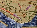
Al-Idrisi drew the Tabula Rogeriana in 1154. He made it for the Norman King Roger II of Sicily. He had spent eighteen years at the king's court working on the map. The map had labels written in Arabic. It showed all of Eurasia. It also showed the northern part of Africa. However, it did not have many details for the Horn of Africa or Southeast Asia.
For King Roger, the map was carved onto a huge silver disc. This disc was two meters (about 6.5 feet) wide.
Al-Idrisi's work was very important for geography. For three centuries, other mapmakers copied his maps. His maps showed the Nile River's lakes in a way that was similar to what explorers found 700 years later.
His work influenced many Islamic scholars. However, it was not well known in Western Europe. It did not have much impact on later European mapmaking.
Islands in the North Sea
In his Tabula Rogeriana, al-Idrisi mentioned Irlandah-al-Kabirah (Great Ireland). He said that sailing from Iceland to Great Ireland took "one day." Historians think this likely referred to Greenland.
Chinese Trade Routes
Al-Idrisi wrote about Chinese trade. He mentioned that Chinese ships called junks carried goods like leather, swords, iron, and silk. He noted the glassware from the city of Hangzhou. He also said that silk from Quanzhou was the best.
Al-Idrisi was one of the first Arabs to write about the Silla Dynasty. This was an important historical dynasty in Korea. It was a major trading partner with China at the time.
Nuzhat al-Mushtaq Book
Besides his maps, al-Idrisi wrote a large book of geographical information. Its full title is Kitab nuzhat al-mushtaq fi'khtiraq al-'afaq. This can be translated as The book of pleasant journeys into faraway lands. Or, it can be called The pleasure of him who longs to cross the horizons. Nine copies of this book still exist today. Seven of these copies include maps.
A mountain range on Pluto is named Al-Idrisi Montes after him. This name was chosen because of the translated title of his book.
In his introduction, al-Idrisi mentioned his sources. He used information from Claudius Ptolemy. He also used reports from an astronomer named Ishaq ibn al-Hasan al-Zayyat. He checked different oral reports to make sure his geographical information was correct.
Early Publications
A shorter version of al-Idrisi's Arabic text was printed in Rome in 1592. This was one of the first Arabic books ever printed. The first translation into another language was into Latin. This Latin version was published in Paris in 1619. A full translation into French was not published until the mid-1800s.
Stories of Atlantic Exploration
Al-Idrisi's book, Nuzhat al-Mushtaq, includes stories about the Atlantic Ocean. He wrote about a group of adventurers called the Mugharrarin. They sailed from Lisbon to explore the "ocean of fogs."
He wrote that after sailing for twelve days, they saw an island. It looked inhabited and had cultivated fields. They were captured by people with red skin and straight hair. Their women were very beautiful.
Another part of the story says they reached an area of "sticky and stinking waters." Then they found an uninhabited island with bitter-tasting sheep. They continued south and found another island. Its people had fair hair. One person spoke Arabic. The king of the village sent them back to the mainland, where Berbers welcomed them.
These stories are often seen as a mix of fact and legend. Some think the "sticky waters" might refer to the Sargasso Sea. The islands they visited could have been the Azores, Madeira, or the Canary Islands. The people they met might have been the Guanches, the native people of the Canary Islands. This would explain why some could speak Arabic, as there were some contacts with Morocco. These accounts show that people in Al-Andalus and Morocco had some knowledge of the Atlantic Ocean.
Medical Dictionary
Al-Idrisi also created a medical dictionary. In this book, he listed simple medicinal plants and their healing effects. This book was used by doctors, pharmacists, and merchants.
The list is special because it includes the names of drugs in many languages. These include Spanish, Berber, Latin, Greek, and Sanskrit. It also has about sixty Hebrew terms. These terms were likely given to him by Jewish people from Al-Andalus. At the end of the book, he provided an index of all the herbs.
In Popular Culture
- Al-Idrisi is a character in Tariq Ali's book A Sultan in Palermo.
- He is also a main character in Karol Szymanowski's 1926 opera, King Roger.
- His ideas about the "Sea of Darkness" are mentioned in Pascal Mercier's book Night Train to Lisbon.
- The popular IDRISI GIS system, used for mapping, is named after him. It was developed by Clark University.
- Al-Idrisi is a supporting character in Zeyn Joukhadar's novel The Map of Salt and Stars.
- In 2019, the Factum Foundation for Digital Technology in Conservation made a silver disk. It was 2 meters wide. This disk was an interpretation of Al-Idrisi's world map.
Images for kids
-
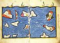
Al-Idrisi's map of the Indian Ocean.
-
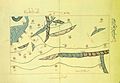
Al-Idrisi's map of North West Persian what is modern day Iranian Azerbaijan and the Caspian Sea.
-

Al-Idrisi's map of the northern shoreline of Marmara Region.
-
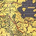
Al-Idrisi's map of the Balkans.
-
Al-Idrisi's map of the Balkans.
-
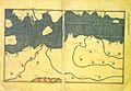
Al-Idrisi's map of the Iberian peninsula.
-
Al-Idrisi's map of the Iberian peninsula.
-
Al-Idrisi's description of Finland
-
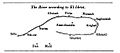
Map of the Senegal River according to al-Idrisi.


See also
 In Spanish: Al-Idrisi para niños
