
Alexander County, Illinois facts for kids
Quick facts for kids
Alexander County
|
|
|---|---|

Alexander County Courthouse in Cairo
|
|

Location within the U.S. state of Illinois
|
|
 Illinois's location within the U.S. |
|
| Country | |
| State | |
| Founded | 1819 |
| Named for | William M. Alexander |
| Seat | Cairo |
| Largest city | Cairo |
| Area | |
| • Total | 253 sq mi (660 km2) |
| • Land | 236 sq mi (610 km2) |
| • Water | 17 sq mi (40 km2) 6.8% |
| Population
(2020)
|
|
| • Total | 5,240 |
| • Estimate
(2023)
|
4,695 |
| • Density | 20.71/sq mi (7.997/km2) |
| Time zone | UTC−6 (Central) |
| • Summer (DST) | UTC−5 (CDT) |
| Congressional district | 12th |
Alexander County is the county farthest south in Illinois, a state in the United States. In 2020, about 5,240 people lived there. The main town, or county seat, is Cairo. The mighty Mississippi River forms the western edge of the county. Alexander County is also part of a larger area called the Cape Girardeau-Jackson Metropolitan Area, which includes towns on both sides of the Mississippi River in Missouri and Illinois.
Contents
History of Alexander County
Alexander County was created in 1819 from parts of Union County. It was named after William M. Alexander. He was a doctor who lived in the town of America. America was the very first county seat.
Later, the county seat moved a few times. In 1833, it moved to Unity. Then in 1843, it moved to Thebes. Finally, in 1860, Cairo became the permanent county seat. Part of Alexander County was used to form Pulaski County in 1843.
Geography and Nature
Alexander County covers about 253 square miles. Most of this is land, but about 17 square miles are water. The county's edges are partly formed by two big rivers: the Mississippi River and the Ohio River.
The lowest point in the entire state of Illinois is found here. It's on the Mississippi River in Cairo, where the river leaves Illinois and flows into Kentucky.
Neighboring Counties
Alexander County shares its borders with several other counties:
- Union County to the north
- Pulaski County to the east
- Ballard County, Kentucky to the southeast
- Mississippi County, Missouri to the south
- Scott County, Missouri to the west
- Cape Girardeau County, Missouri to the northwest
Protected Natural Areas
Parts of two important natural areas are located in Alexander County:
- Cypress Creek National Wildlife Refuge
- Shawnee National Forest
Main Roads and Highways
Several major roads pass through Alexander County, helping people travel around:
 Interstate 57
 U.S. Route 51
 U.S. Route 60
 U.S. Route 62
 Illinois Route 3
 Illinois Route 37
 Illinois Route 127
 Illinois Route 146
Climate and Weather in Alexander County
| Weather chart for Cairo, Illinois | |||||||||||||||||||||||||||||||||||||||||||||||
|---|---|---|---|---|---|---|---|---|---|---|---|---|---|---|---|---|---|---|---|---|---|---|---|---|---|---|---|---|---|---|---|---|---|---|---|---|---|---|---|---|---|---|---|---|---|---|---|
| J | F | M | A | M | J | J | A | S | O | N | D | ||||||||||||||||||||||||||||||||||||
|
3.2
41
26
|
3.6
48
30
|
4.4
58
39
|
4.7
69
50
|
4.8
78
59
|
4.2
86
67
|
4.4
90
71
|
3.6
87
69
|
3
81
61
|
3.4
71
49
|
4.4
57
39
|
4.2
46
30
|
||||||||||||||||||||||||||||||||||||
| temperatures in °F precipitation totals in inches source: The Weather Channel |
|||||||||||||||||||||||||||||||||||||||||||||||
|
Metric conversion
|
|||||||||||||||||||||||||||||||||||||||||||||||
In Cairo, the county seat, temperatures usually range from about 26°F (around -3°C) in January to 90°F (around 32°C) in July. The coldest temperature ever recorded was -12°F (-24°C) in January 1985. The hottest was 104°F (40°C) in June 1954. The county gets about 3 to 4.7 inches of rain each month.
Population and People
| Historical population | |||
|---|---|---|---|
| Census | Pop. | %± | |
| 1820 | 626 | — | |
| 1830 | 1,390 | 122.0% | |
| 1840 | 3,313 | 138.3% | |
| 1850 | 2,484 | −25.0% | |
| 1860 | 4,707 | 89.5% | |
| 1870 | 10,564 | 124.4% | |
| 1880 | 14,808 | 40.2% | |
| 1890 | 16,563 | 11.9% | |
| 1900 | 19,384 | 17.0% | |
| 1910 | 22,741 | 17.3% | |
| 1920 | 23,980 | 5.4% | |
| 1930 | 22,542 | −6.0% | |
| 1940 | 25,496 | 13.1% | |
| 1950 | 20,316 | −20.3% | |
| 1960 | 16,061 | −20.9% | |
| 1970 | 12,015 | −25.2% | |
| 1980 | 12,264 | 2.1% | |
| 1990 | 10,626 | −13.4% | |
| 2000 | 9,590 | −9.7% | |
| 2010 | 8,238 | −14.1% | |
| 2020 | 5,240 | −36.4% | |
| 2023 (est.) | 4,695 | −43.0% | |
| U.S. Decennial Census 1790-1960 1900-1990 1990-2000 2010-2020 2020 |
|||

In 2010, about 8,238 people lived in Alexander County. By 2020, the population had dropped to 5,240. This was a big decrease, the largest in any U.S. county during that time. The population has been going down for many years. The closing of a large state facility in Tamms in 2013 likely caused the population to drop even faster.
Most people in the county are White or African American. A small number of people are from other racial backgrounds. About 1.9% of the population in 2010 was of Hispanic or Latino origin.
The average age of people in Alexander County in 2010 was about 41 years old. The average income for a family was around $44,699. About 20% of the people in the county lived below the poverty line. This included about 33% of children under 18.
Education in Alexander County
Several school districts serve the students of Alexander County. These districts may also include areas in other counties.
- Cairo Unified School District 1
- Century Community Unit School District 100
- Egyptian Community Unit School District 5
- Meridian Community Unit School District 101
- Shawnee Community Unit School District 84
Towns and Villages
Alexander County has one city and several villages and smaller communities.
City
Villages
Census-designated place
Unincorporated Communities
Images for kids
-
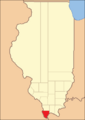
Alexander County between 1819 and 1843.
-
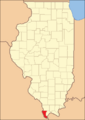
Alexander County reduced to its current borders in 1843 with the creation of Pulaski County.


See also
 In Spanish: Condado de Alexander (Illinois) para niños
