Aonach Eagach facts for kids
Quick facts for kids Aonach Eagach - Sgor nam Fiannaidh |
|
|---|---|

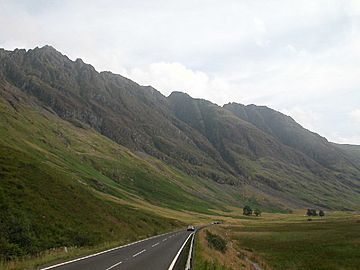
The Aonach Eagach above the A82, looking up Glen Coe
|
|
| Highest point | |
| Elevation | 967.7 m (3,175 ft) |
| Prominence | 623 m (2,044 ft) |
| Parent peak | Ben Alder |
| Listing | Munro, Marilyn |
| Naming | |
| English translation | Notched Upland - Rocky peak of Fian's warriors |
| Language of name | Gaelic |
| Geography | |
| Location | Glen Coe, Scotland |
| Parent range | Grampian Mountains |
| OS grid | NN141583 |
| Topo map | OS Landranger 41 |
| Listed summits of Aonach Eagach | ||||
| Name | Grid ref | Height | Status | |
|---|---|---|---|---|
| Sgorr nam Fiannaidh | NN14065830 | 967.7 m (3,175 ft) | Munro | |
| Meall Dearg | NN16135835 | 952.2 m (3,124 ft) | Munro | |
- For the mathematical function known as a "Devil's staircase", see Singular function.
The Aonach Eagach is a rocky mountain ridge. It is located north of Glen Coe in the Scottish Highlands. This ridge has two high peaks called Munros. The full ridge is about 10 kilometers long. It stretches from the Pap of Glencoe in the west to the Devil's Staircase in the east.
The middle part of the ridge is about 2 kilometers long. It is very rocky and needs climbing skills to get across. The sides of the ridge are very dangerous. They have steep grassy and rocky slopes that drop off into cliffs. These cliffs are on both the north and south sides.
The Aonach Eagach is often called the trickiest mountain ridge to climb in mainland Scotland. It is often compared to Liathach for this title. A local climber named Noel Williams wrote a book about climbing in the area. He warned that it's hard to get off the ridge once you start. He also said some parts are very narrow. He gave it a Grade 2 difficulty rating. He added that it's not safe to go down the south side of the ridge.
Climbing the Aonach Eagach Ridge
People usually climb the Aonach Eagach from the south side of Glen Coe. They go from east to west. The best place to park is near the A82 road. From a spot called Allt-na-reigh, a good path goes up a smaller peak called Am Bodach. The path then continues west along the ridge. It leads to the first main Munro peak, Meall Dearg.
From Meall Dearg, the peak of Sgorr nam Fiannaidh is only two kilometers to the west. But you have to climb over several rocky points. It can take more than two hours to cross this short distance. Some groups might use a rope for safety on a few parts.
In winter, climbing the ridge is a great adventure. However, it is much harder than in summer. Many groups will use ropes for some sections. Because winter days are short, climbers can often be caught out by darkness. This can happen while on the ridge or on the paths leading to it.
Going Down the Ridge
Experienced summer climbers can go back the way they came. They can descend Am Bodach. This saves them a long walk back along the glen road.
From Sgorr nam Fiannaidh, the quickest way down is to head south. This path goes down a steep, zig-zag trail next to Clachaig gully. This path is very steep and loose in places. It also has small rock steps. It gets close to the main gully in several spots, which can be dangerous. Sadly, accidents have happened here.
A safer option is to keep going along the ridge. You will reach the pass between Sgorr nam Fiannaidh and the Pap of Glencoe. From here, a track goes down the hillside. It ends on the road near Glencoe village.
Another way to go down is to walk back about 200 meters east from the top of Sgorr nam Fiannaidh. Then, you can go straight down a rocky slope to Loch Achtriochtan. You need to be careful not to go into any gullies further down. This way also needs care, especially near the top. But it is still much safer than the Clachaig Gully path.
You can also climb the two Munros separately. You would just go down the same way you came up. But the Aonach Eagach is best known for climbing the whole ridge.
Devil's Staircase

A path called the Devil's Staircase crosses the mountain range. It is about 6 kilometers east of Meall Dearg. Today, this path is part of the West Highland Way. It is mostly used by walkers and mountain bikers. They travel between Kinlochleven and Glencoe.
The Devil's Staircase got its name from soldiers. They were building roads for General Wade. It was very hard to carry building materials up this part of the road. Later, the road also became known for workers from the Blackwater Dam. They would walk to the Kings House Hotel after getting paid. This journey often became difficult, especially on a cold winter night after a few drinks.
In 1692, this path was used by troops coming from Kinlochleven. They were supposed to help during the Massacre of Glencoe. However, they were delayed.
 | Isaac Myers |
 | D. Hamilton Jackson |
 | A. Philip Randolph |

