Appling County, Georgia facts for kids
Quick facts for kids
Appling County
|
|
|---|---|

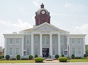
Appling County Courthouse in Baxley
|
|

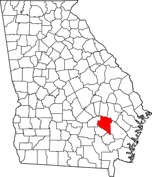
Location within the U.S. state of Georgia
|
|
 Georgia's location within the U.S. |
|
| Country | |
| State | |
| Founded | December 15, 1818 |
| Named for | Daniel Appling |
| Seat | Baxley |
| Largest city | Baxley |
| Area | |
| • Total | 512 sq mi (1,330 km2) |
| • Land | 507 sq mi (1,310 km2) |
| • Water | 5.2 sq mi (13 km2) 1.0% |
| Population
(2020)
|
|
| • Total | 18,444 |
| • Density | 36.02/sq mi (13.909/km2) |
| Time zone | UTC−5 (Eastern) |
| • Summer (DST) | UTC−4 (EDT) |
| Congressional district | 1st |
Appling County is a county in the southeastern part of Georgia. In 2020, about 18,444 people lived there. The main town, or county seat, is Baxley.
Contents
History
Appling County is named after Lieutenant Colonel Daniel Appling. He was a soldier who fought in the War of 1812. The county was officially created on December 15, 1818. It was the 42nd county made in Georgia.
The land for Appling County came from the Creek people. They gave up these lands in treaties signed in 1814 and 1818.
Early Growth and Land Lotteries
During the 1820s, more people moved to Appling County. The state of Georgia held "land lotteries" in 1820, 1821, 1827, and 1832. These lotteries gave people a chance to win land. Many new settlers came from South Carolina and nearby Tattnall County, Georgia.
Changes to County Borders
Over the years, parts of Appling County were used to create new counties. On December 15, 1824, Ware County was formed from a large southern part of Appling County.
Later, on December 24, 1825, a section of Appling County was added to Telfair County. This caused some confusion about the exact border.
On December 18, 1857, a southern part of Appling County was used to create Pierce County.
Finding a County Seat
For over ten years, there was disagreement about where the county seat should be. A county seat is the main town where the county government is located. On December 8, 1828, Holmesville, Georgia was chosen as the county seat. Before this, court meetings were held at a person's home.
In 1836, a group was asked to find a new, more central location for the county seat. However, they couldn't agree. The need for a central county seat remained a big topic in local politics for many years.
Population Changes and New County Seats
By 1850, Appling County had a population of 2,949 people. By 1860, the population had grown to 4,190.
On August 27, 1872, eastern parts of Appling County were added to Wayne County. This area included Jesup, Georgia, which became Wayne County's new county seat in 1873.
Also in August 1872, people in Appling County voted to move their county seat. They chose Baxley, Georgia as the new county seat. Baxley was located along the Macon and Brunswick Railroad, which made it easier to reach.
More Counties Formed
On August 18, 1905, Jeff Davis County was created. It took land from both Appling County and Coffee County.
Later, on July 27, 1914, Bacon County was formed. It was made from parts of Appling, Pierce, and Ware counties. The remaining part of Appling County south of the Little Satilla River became part of Bacon County.
Geography
The U.S. Census Bureau says Appling County covers a total area of 512 square miles. Most of this area, about 507 square miles, is land. The rest, about 5.2 square miles, is water.
Rivers and Basins
The southern two-thirds of Appling County is part of the Little Satilla River area. This river flows into the St. Marys River-Satilla River basin. The northern third of the county is in the Altamaha River area.
Major Highways
 U.S. Route 1
 U.S. Route 23
 U.S. Route 341
 State Route 4
 State Route 15
 State Route 19
 State Route 27
 State Route 121
 State Route 144
 State Route 169
 State Route 203
Neighboring Counties
- Toombs County - north
- Tattnall County - northeast
- Wayne County - southeast
- Pierce County - south
- Jeff Davis County - west
- Bacon County - west
Communities
Cities
Town
Demographics
| Historical population | |||
|---|---|---|---|
| Census | Pop. | %± | |
| 1820 | 1,264 | — | |
| 1830 | 1,468 | 16.1% | |
| 1840 | 2,052 | 39.8% | |
| 1850 | 2,949 | 43.7% | |
| 1860 | 4,190 | 42.1% | |
| 1870 | 5,086 | 21.4% | |
| 1880 | 5,276 | 3.7% | |
| 1890 | 8,676 | 64.4% | |
| 1900 | 12,336 | 42.2% | |
| 1910 | 12,318 | −0.1% | |
| 1920 | 10,594 | −14.0% | |
| 1930 | 13,314 | 25.7% | |
| 1940 | 14,497 | 8.9% | |
| 1950 | 14,003 | −3.4% | |
| 1960 | 13,246 | −5.4% | |
| 1970 | 12,726 | −3.9% | |
| 1980 | 15,565 | 22.3% | |
| 1990 | 15,744 | 1.2% | |
| 2000 | 17,419 | 10.6% | |
| 2010 | 18,236 | 4.7% | |
| 2020 | 18,444 | 1.1% | |
| 2023 (est.) | 18,457 | 1.2% | |
| U.S. Decennial Census 1790-1880 1890-1910 1920-1930 1930-1940 1940-1950 1960-1980 1980-2000 2010-2020 |
|||
Here's a look at the different groups of people living in Appling County in 2020:
| Race | Num. | Perc. |
|---|---|---|
| White (non-Hispanic) | 12,674 | 68.72% |
| Black or African American (non-Hispanic) | 3,339 | 18.1% |
| Native American | 33 | 0.18% |
| Asian | 123 | 0.67% |
| Pacific Islander | 1 | 0.01% |
| Other/Mixed | 449 | 2.43% |
| Hispanic or Latino | 1,825 | 9.89% |
In 2020, there were 18,444 people living in Appling County.
Education
See also
 In Spanish: Condado de Appling para niños

