
Ardsley, New York facts for kids
Quick facts for kids
Ardsley, New York
|
|||
|---|---|---|---|

Downtown Ardsley
|
|||
|
|||

Location of Ardsley, New York
|
|||
| Country | United States | ||
| State | New York | ||
| County | Westchester | ||
| Town | Greenburgh | ||
| Area | |||
| • Total | 1.32 sq mi (3.42 km2) | ||
| • Land | 1.32 sq mi (3.42 km2) | ||
| • Water | 0.00 sq mi (0.00 km2) | ||
| Elevation | 210 ft (64 m) | ||
| Population
(2020)
|
|||
| • Total | 5,079 | ||
| • Density | 3,844.81/sq mi (1,484.49/km2) | ||
| Time zone | UTC-5 (Eastern (EST)) | ||
| • Summer (DST) | UTC-4 (EDT) | ||
| ZIP Code |
10502
|
||
| Area code(s) | 914 | ||
| FIPS code | 36-02506 | ||
| GNIS feature ID | 0942544 | ||


Ardsley is a small village located in Westchester County, New York. It is part of a larger area called the town of Greenburgh. In 2020, about 5,079 people lived here. The village is led by its mayor, Nancy Kaboolian.
Ardsley has its own post office and a school district. This school district serves students from the village and nearby areas. The village also has a library that is part of the Westchester Library System. It is important not to confuse Ardsley with Ardsley-on-Hudson. That is a different small community nearby.
Contents
A Look Back in Time: Ardsley's History
Early Inhabitants and Land Ownership
Before European settlers arrived, the land where Ardsley now stands was home to the Wickquasgeck tribe. They were part of the Wappinger people. These tribes were related to the Lenape (Delaware) tribes. The Lenape lived across lower New York state and New Jersey.
Later, the Dutch came to this area. The land became part of a large property owned by Frederick Philipse. He bought it in 1682. After the American Revolution, the state of New York took the land from Philipse's grandson. He had supported the British. The state then sold the land to local farmers. These farmers had been renting the land from the Philipse family.
How Ardsley Grew and Changed
A community called Ashford first formed from parts of this land. It was named after the main road. Early businesses included a blacksmith shop. There was also a sawmill and a grist mill. Both of these mills were located on the Saw Mill River. By the time of the American Civil War, three pickle factories were operating.
In the 1880s, two big projects helped Ardsley grow. The Putnam Railroad was built. Also, the New Croton Aqueduct was constructed. These projects brought more people to the area. This led to new things like electric lighting and better roads.
Why the Name Changed to Ardsley
The town had to change its name from Ashford. This was because another Ashford Post Office already existed in New York state. The name "Ardsley" was chosen because of Cyrus West Field. He owned a large piece of land nearby called Ardsley Park. He had named his home after the English birthplace of his ancestor. That place was East Ardsley in England.
The story goes that Field helped the village get its own post office. In return, the village agreed to be renamed Ardsley. The first postmaster for the village was appointed in 1883.
Modern Growth and Development
Ardsley officially became an incorporated town in 1896. Ardsley High School opened in 1912. The town continued to grow steadily. However, a fire destroyed the village center in 1914. This led to new buildings being constructed. It also led to the creation of a fire department.
Ardsley experienced two major population booms. The first was after World War I. The second happened after World War II. A new elementary school, Concord Road, was built in 1953. The original high school became too small. So, a new high school opened in 1957. The old school then became a middle school. A new middle school building was constructed in 1971.
The village changed a lot in the late 1950s. This was due to the building of the New York State Thruway. This highway caused the loss of the Ardsley train station. It also led to the loss of many businesses in the downtown area.
Where is Ardsley?
Geography and Waterways
Ardsley covers an area of about 1.3 square miles. All of this area is land.
The Saw Mill River and Sprain Brook are two waterways. They both flow through Ardsley. Sometimes, the Saw Mill River has caused flooding. This has damaged homes, businesses, and village buildings. Major floods happened in 1980, 1984, and 1999. The Army Corps of Engineers has completed projects. These projects help to reduce flood damage in downtown Ardsley.
Climate in Ardsley
Ardsley has a climate with hot, humid summers. The winters are generally mild to cool. This type of climate is called a humid subtropical climate. It usually receives about 28 inches of snow each year.
Who Lives in Ardsley?
| Historical population | |||
|---|---|---|---|
| Census | Pop. | %± | |
| 1900 | 404 | — | |
| 1910 | 537 | 32.9% | |
| 1920 | 730 | 35.9% | |
| 1930 | 1,135 | 55.5% | |
| 1940 | 1,423 | 25.4% | |
| 1950 | 1,744 | 22.6% | |
| 1960 | 3,991 | 128.8% | |
| 1970 | 4,470 | 12.0% | |
| 1980 | 4,183 | −6.4% | |
| 1990 | 4,272 | 2.1% | |
| 2000 | 4,269 | −0.1% | |
| 2010 | 4,452 | 4.3% | |
| 2020 | 5,079 | 14.1% | |
| 2021 (est.) | 5,006 | 12.4% | |
| U.S. Decennial Census | |||
In 2000, there were 4,269 people living in Ardsley. There were 1,432 households. Most households (75.1%) were married couples. About 43.5% of households had children under 18. The average household had almost 3 people.
The population was spread out by age. About 27.9% were under 18. About 15.3% were 65 or older. The average age was 42 years old.
In 2018, the U.S. Census Bureau estimated that 4,534 people lived in the village. The population is diverse. About 68.3% were non-Hispanic white. About 15.5% were Asian. And about 8.2% were Hispanic or Latino.
Learning in Ardsley
The Ardsley Union Free School District manages the public schools in the village. Ardsley High School is the main high school for the district.
The Lyceum Kennedy International School also has a campus in Ardsley. It serves students in elementary grades.
Ardsley's Culture
In 2018, a writer for The New York Times described Ardsley as one of the "Rivertowns." These towns are known for their unique culture. Even though Ardsley is not right next to a river, it shares a similar vibe. These towns are seen as less typical suburbs. They are liked for their culture and cool factor.
Getting Around Ardsley
Public Transportation Options
The Bee-Line Bus System provides bus service in Ardsley. Several bus lines run through the village. These lines connect Ardsley to other places. You can travel to Elmsford, White Plains, and Getty Square, Yonkers. Other lines go east and west. They connect to train stations and downtown areas. These include Dobbs Ferry, Scarsdale, and New Rochelle.
The New York and Putnam Railroad no longer operates. It was replaced by Interstate 87. Now, people can take commuter trains to New York City. The Metro-North Railroad's Hudson Line serves the Dobbs Ferry and Ardsley-on-Hudson stations. The Harlem Line serves the Hartsdale and Scarsdale stations.
Pathways for Walking and Biking
Ardsley also has the South County Trail. This trail is only for walking and biking. It connects Ardsley to the larger Empire State Trail across New York State. Many people use the trail for strolls or to get to places. You can reach Elmsford or Yonkers using the trail. The trail follows the old path of the New York and Putnam Railroad.
Notable People from Ardsley
- David Oks, writer and political activist
- Harold Goldsmith (1930–2004), Olympic foil and épée fencer
- Jesse McCartney, singer, songwriter, and actor
- Timothy A. McDonnell, a leader in the Roman Catholic Church
- Marshall Rogers, comics artist
- Funkmaster Flex, professional disc jockey
- Jane Schoenbrun, filmmaker
Images for kids
-
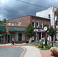
Downtown Ardsley
-
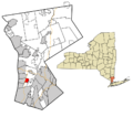
Location of Ardsley, New York
-
Map of Ardsley
-
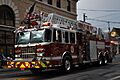
Ardsley Fire Department engine
See also
 In Spanish: Ardsley (Nueva York) para niños
