
Athol, Massachusetts facts for kids
Quick facts for kids
Athol, Massachusetts
|
|||
|---|---|---|---|

Millers River
|
|||
|
|||
| Nickname(s):
Tool Town
|
|||

Location in Worcester County and the state of Massachusetts.
|
|||
| Country | United States | ||
| State | Massachusetts | ||
| County | Worcester | ||
| Settled | 1735 | ||
| Incorporated | 1762 | ||
| Government | |||
| • Type | Open town meeting | ||
| Area | |||
| • Total | 33.4 sq mi (86.5 km2) | ||
| • Land | 32.6 sq mi (84.4 km2) | ||
| • Water | 0.8 sq mi (2.1 km2) | ||
| Elevation | 546 ft (166 m) | ||
| Population
(2020)
|
|||
| • Total | 11,945 | ||
| • Density | 357.6/sq mi (138.09/km2) | ||
| Time zone | UTC-5 (Eastern) | ||
| • Summer (DST) | UTC-4 (Eastern) | ||
| ZIP code |
01331
|
||
| Area code(s) | 351 / 978 | ||
| FIPS code | 25-02480 | ||
| GNIS feature ID | 0619473 | ||
| Website | www.athol-ma.gov | ||


Athol (pronounced ATH-awl) is a town in Worcester County, Massachusetts, United States. In 2020, about 11,945 people lived there.
Contents
History of Athol
.jpg)
The area was first called Pequoiag by Native Americans. In September 1735, five families settled here. When the town officially became a town in 1762, its name changed to Athol. John Murray, one of the land owners, chose the name. Some believe it means "New Ireland."
Early residents were mostly farmers and hunters. By 1791, Athol had many mills that used water power. These included mills for grinding grain, cutting wood, and processing cloth. The Athol Cotton Factory, built in 1811, was one of the first big industries.
Throughout the 1800s, industries like textiles, leather, wood, and metal grew. The building of railroads in the 1840s and 1870s helped these industries grow even more. Trains connected Athol to other cities like Springfield and Boston.
The Athol Machine Company started in 1868. It made a special chopping machine invented by Laroy S. Starrett. In 1881, Mr. Starrett started the L. S. Starrett Company. This company is famous for making high-quality tools that are very precise. It is still the town's biggest employer today. This is why Athol is known as "Tool Town."
As factories grew along the river, homes and shops appeared around the town common. This area, now called Uptown, was where the first bank was. Trolley lines started in 1894, making it easy to travel to nearby towns like Orange. By the early 1900s, Athol was a busy center for industry, business, and transportation.
In the 1930s, trolleys stopped running because more people had cars and buses became common. Also, the economy was tough. When four towns were flooded to create the Quabbin Reservoir, a railroad route had to close. This slowed Athol's growth. The town's population reached its highest point of 12,186 in 1955.
A new highway, Route 2, was built around Athol in the 1950s. This meant less traffic went through the downtown area. The population then went down, reaching a low of 10,634 in 1980. However, Athol's population has slowly grown since then.
Athol's Geography
Athol covers about 33.4 square miles (86.5 square kilometers). Most of this is land, with a small part being water. The Millers River flows through the town, especially the downtown area. The Tully River also flows into the Millers River here.
Athol has many streams, lakes, and ponds. The land is hilly and covered with woods. Elevations range from about 500 feet (152 meters) near the Millers River to 1,282 feet (391 meters) at the top of Pratt Hill. A large part of the Millers River Wildlife Management Area is in Athol.
Athol is on the western edge of Worcester County. It is next to Franklin County. Nearby towns include Royalston to the north and Orange to the west. Athol is about 23 miles (37 km) east of Greenfield and 67 miles (108 km) west of Boston. Most people live in the downtown area, while other parts of town are less populated.
Town Economy

Since the Civil War, Athol's economy has mainly been about factories and manufacturing. In the early 1900s, the local water power and train service attracted companies like Union Twist Drill and the L. S. Starrett Company. This led to Athol's nickname, "Tool Town."
In the 1950s, new highways like Route 2 and Interstate 495 changed traffic patterns. This caused Athol and other towns in central Massachusetts to face a long period of economic decline. By 1998, many stores in Athol were empty.
Today, the L. S. Starrett Company is still the biggest employer in town. The Athol Memorial Hospital is the second largest. Most other jobs in Athol are in retail stores and restaurants.
In the 1960s, Athol and Orange worked together to bring new businesses to the area near the Orange Municipal Airport. Groups like the Millers River Community Development Corporation helped people find housing.
In the early 1980s, the state gave money to the North Quabbin region (including Athol and Orange) to help its economy grow. This was because the area had a very high unemployment rate. This funding helped, but then a recession hit.
In the 1990s, a Walmart opened in Orange, close to Athol. This caused some businesses on Athol's Main Street to close.
More recently, in the 2010s, a new shopping plaza opened in Athol. It has a Market Basket grocery store, a movie theater, and other shops and restaurants. In the 2020s, new businesses have opened on Main Street, making fewer storefronts empty.
Groups like the Economic Development and Industrial Corporation and the North Quabbin Chamber of Commerce are still working to improve Athol's economy.
Population Information
| Historical population | ||
|---|---|---|
| Year | Pop. | ±% |
| 1850 | 2,034 | — |
| 1860 | 2,604 | +28.0% |
| 1870 | 3,517 | +35.1% |
| 1880 | 4,307 | +22.5% |
| 1890 | 6,319 | +46.7% |
| 1900 | 7,061 | +11.7% |
| 1910 | 8,536 | +20.9% |
| 1920 | 9,792 | +14.7% |
| 1930 | 10,677 | +9.0% |
| 1940 | 11,180 | +4.7% |
| 1950 | 11,554 | +3.3% |
| 1960 | 11,637 | +0.7% |
| 1970 | 11,185 | −3.9% |
| 1980 | 10,634 | −4.9% |
| 1990 | 11,451 | +7.7% |
| 2000 | 11,299 | −1.3% |
| 2010 | 11,584 | +2.5% |
| 2020 | 11,945 | +3.1% |
| 2022 | 11,897 | −0.4% |
Source: United States Census records and Population Estimates Program data. |
||
In 2000, there were 11,299 people living in Athol. There were 4,487 households and 2,970 families. The town had about 347 people per square mile (134 people per square kilometer).
Most people in Athol were White (96.33%). Other groups included Black or African American, Native American, and Asian. About 2% of the population was Hispanic or Latino. Many residents have French, French Canadian, English, Irish, or Italian backgrounds.
About 31.6% of households had children under 18. About half of the households (49.1%) were married couples. The average household had 2.46 people.
The population's age was spread out. About 25.4% were under 18, and 17.2% were 65 or older. The average age was 39 years.
Communications in Athol
Athol has its own daily newspaper, The Athol Daily News. Other newspapers from nearby cities also cover news in Athol.
Time Warner Cable provides cable TV service to the area. Athol-Orange Community Television, Inc. (AOTV) is a local non-profit group. It helps people create their own TV shows and broadcasts public meetings. AOTV also runs a local radio station, WVAO-LP 105.9 FM.
Other radio stations can be heard in Athol from nearby towns and cities. High-speed internet is available in some parts of town.
Transportation Options
Many people in Athol can walk to shops and businesses downtown. However, for traveling outside of town, most people use cars. Athol is located along Route 2, which is a main highway that goes east and west through northern Massachusetts.
U.S. Route 202 also runs through Athol with Route 2. The old route, now Route 2A, goes through downtown Athol. Route 2A connects Athol to Orange to the west and Gardner to the east. Route 2 connects to Greenfield (20 miles west) and Boston (71 miles east).
Athol has several bus lines. The Franklin Regional Transit Authority (FRTA) has daily buses to places west of Athol. The Montachusett Regional Transit Authority (MART) serves areas east of town. There are also special "dial-a-ride" services for people who need help getting to work or appointments.
The closest airport for small planes is the Orange Municipal Airport. For bigger flights, the nearest airports are Bradley International Airport and Manchester-Boston Regional Airport, both about an hour's drive away.
Athol still has its old train station downtown. There is a plan called "Northern Tier Passenger Rail" to bring passenger train service back to Athol. This would connect Athol to MBTA's Fitchburg Line and other towns.
Education in Athol
The Athol-Royalston Regional School District teaches students from preschool to 12th grade. There are two elementary schools: Athol Community Elementary School (Pre-K to 4) and Royalston Community School (K–6). The Athol-Royalston Middle School has grades 5 to 8, and Athol High School has grades 9 to 12.
Students can also choose to go to the Montachusett Regional Vocational Technical School in Fitchburg. Athol High School has worked hard to keep its full accreditation, which means it meets high standards for education.
For higher education, the closest community colleges are Mount Wachusett Community College in Gardner and Greenfield Community College in Greenfield. There are also colleges and universities in Amherst, Fitchburg, Worcester, and Keene.
For younger children, there are private day care centers and nursery schools. The Athol Public Library has many activities for preschoolers, like story times and craft workshops. The Athol Area YMCA also has programs for young children, including a preschool and after-school care.
The Athol Public Library started in 1882. It was rebuilt in 1918 and was the first building in Athol to have air conditioning in 1969.
Culture in Athol
Athol is a bit far from the big cultural centers of Massachusetts. Because of this, people in Athol often create their own fun and entertainment. The town is known for having many talented musicians.
Groups like the Athol Area YMCA, the Athol Historical Society, and the Athol Public Library organize events and programs. The Athol Cultural Council helps fund some of these activities.
The Athol Public Library has programs for young adults, like craft workshops and author visits. The children's library also offers weekly programs for toddlers, preschoolers, and preteens.
Community groups like the Athol Lions Club put on yearly events such as Summerfest and the River Rat Race. The River Rat Race is the town's biggest event, held every April. Thousands of people watch over 300 canoes race down the Millers River from Athol to Orange. There's also a parade and a carnival during this time.
"Tool Town Live!" concerts are held in the summer and early fall. These free concerts feature talented musicians from around New England.
The Athol Historical Society is in the old town hall. It has a museum with items from Athol's past. They also give talks about local history and tours of historic places. The L.S. Starrett Tool Museum also shows old machine tools.
The Millers River Environmental Center is on Main Street. It has exhibits and events and is home to the Athol Bird and Nature Club.
Recreation and Entertainment
Athol and its surroundings offer many chances to enjoy the outdoors. Clubs like the Woodsman Rifle and Pistol Club and the Athol Bird and Nature Club focus on specific outdoor activities.
The Millers River is a big part of outdoor fun. The River Rat Race, an annual canoe race, starts in Athol and ends in Orange.
Athol has six public nature areas managed by the Athol Conservation Commission. The largest is Bearsden Forest, which has hiking trails, camping areas, and ponds.
Protecting nature is important in the North Quabbin region. The Millers River Environmental Center offers programs and is home to the Athol Bird and Nature Club. The Mount Grace Land Conservation Trust works to protect natural areas and farms.
The Alan E. Rich Environmental Park is near the Millers River bridge. It has parking and allows access for canoes, kayaks, and small boats. It's next to Cass Meadow, which has trails for birdwatching.
The southern part of Athol, near the Harvard Forest and the Quabbin Reservoir, has beautiful hiking trails. The town also has Fish Park, Silver Lake, and Lake Ellis, where people can swim, skate, play tennis, or play ball.
Other fun places include the Ellinwood Country Club, which has an 18-hole golf course. The downtown Athol Area YMCA has a pool, gym, and exercise classes. It also runs youth sports leagues and a summer camp called Camp Wiyaka.
Groups like the Boy Scouts, Girl Scouts, and Campfire Girls offer activities for children and young adults. The Athol Recreation Department has summer programs at school playgrounds. Social clubs like the Lions and Rotary clubs also offer many activities for families. Chuck Stone Little League has baseball and softball for kids in Athol and Royalston.
The Silver Lake Wiffleball League plays at Silver Lake Park from April to September. It's open to all adults and is free.
Notable people
- Dave Bargeron, musician
- Jimmy Barrett, baseball player
- Philip Bezanson, composer and educator
- Asa Drury, educator and minister
- Daniel Francis Feehan, bishop
- Isaac Fitzgerald, writer
- Gregory Gibson, author
- George Henry Hoyt, attorney, politician, and Union officer
- Ellen Cheney Johnson, prison reformer
- John Murray, early land owner
- Shawn Patterson, composer and writer of "Everything Is Awesome"
- Kenny Roberts, country music singer
- Lysander Spooner, philosopher and writer
- Charles Starrett, actor
- Laroy S. Starrett, industrialist
- Charles H. Sweetser, author and journalist
- Ginery Twichell, railroad president and congressman
- Donald Goddard Wing, Yale librarian
Images for kids
-
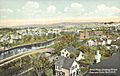
Bird's-eye view in 1908
-
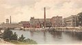
L. S. Starrett Co. in 1905
-
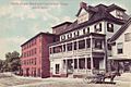
Opera House around 1906
-
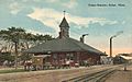
Union Station around 1912


See also
 In Spanish: Athol (Massachusetts) para niños
