
August Heinrich Petermann facts for kids
Quick facts for kids
August Heinrich Petermann
|
|
|---|---|
 |
|
| Born | 18 April 1822 Bleicherode, German Confederation
|
| Died | 25 September 1878 (aged 56) |
| Nationality | German |
| Known for | "No issue without a map" |
| Scientific career | |
| Fields | Cartography |
Augustus Heinrich Petermann (born April 18, 1822 – died September 25, 1878) was a famous German cartographer. A cartographer is someone who makes maps. He was known for saying, "No issue without a map," which showed how much he believed in the power of maps to explain things.
Contents
Early Life and Learning
Petermann was born in Bleicherode, Germany. When he was 14, he started grammar school. His mother wanted him to become a clergyman, but he was so good at drawing maps and loved reading about geography, that he chose a different path.
Learning to Make Maps
In 1839, a man named Heinrich Berghaus started a special school in Potsdam called the 'Geographical School of Art'. It was a place where students learned how to make maps. Berghaus had help from a famous scientist named Alexander von Humboldt.
August Petermann was one of the first students at this school, starting in 1839. His father couldn't afford to pay for his education. But when Berghaus saw August's maps, he knew August had a lot of talent. Berghaus even asked the king for money to help support Petermann's studies, and the king agreed!
What Petermann Studied
At the school, Petermann learned many things about making maps. He studied:
- Mathematical geography: How to draw maps accurately using different map projections (ways to show the round Earth on a flat map).
- Physical geography: Learning about weather (meteorology), water (hydrology), and rocks (geology).
- Political geography: Understanding country borders and how areas are divided.
He also learned practical skills like drawing and engraving maps onto copper plates. This was a very detailed and artistic way to make maps back then. Even though new ways like lithography (a cheaper printing method) were appearing, copper engraving was still the best for making beautiful, detailed maps.
Petermann also met many important geographers and explorers at the school, including Alexander von Humboldt. These meetings helped him learn a lot about the world and new discoveries.
Working in Britain
From 1845 to 1854, August Petermann lived and worked in Scotland and England. This time helped him learn about the business side of map-making.
Time in Scotland
In 1845, Petermann joined Alexander Keith Johnston, a map publisher in Edinburgh, Scotland. They worked together on a big book called the Physical Atlas, which showed maps of Earth's natural features.
While in Edinburgh, Petermann also worked with other publishers and even taught John Bartholomew Jr., who later became a very famous mapmaker himself. Bartholomew learned a lot from the German way of making maps. He became known for using different colors to show heights on maps, with green for lowlands and brown for highlands. This idea might have come from what he learned in Germany.

Moving to London
In 1847, Petermann moved to London. He wanted to continue his studies and then return to Germany, but he found good opportunities in London. He worked for a London magazine and, in 1850, he started his own map-making company called "The Geographical Establishment."
He published several important maps and atlases, including an Atlas of physical geography. He also made maps for the Royal Geographical Society (RGS), a famous group of explorers and geographers. Petermann became a member of the RGS in 1847 and later won their prestigious 'Founders medal' in 1868. Even Queen Victoria recognized his talent, naming him 'physical geographer-royal'.
Petermann was very interested in helping geographical explorations. He encouraged the British government to send scientists like Heinrich Barth and Adolf Overweg on expeditions to Africa. He wanted to make sure that the scientific discoveries from these trips were recorded.
Maps and Writings in English
During his time in Britain, Petermann became very good at both German and English. This helped him read many different reports and articles, which was important for his work. He became very interested in exploring the polar regions (the Arctic and Antarctic) because many explorers shared their discoveries at the Royal Geographical Society.
He published many articles and maps in English. For example, he made maps showing:
- The distribution of active volcanoes and earthquakes.
- The spread of different animal species around the world.
- The routes of explorers in Africa.
- Ideas about exploring the North Pole.
He even made maps about the spread of diseases like cholera in Britain, showing how maps could be better than tables for understanding where and how many people were affected.
Petermanns Geographische Mitteilungen (PGM)
In 1854, Petermann returned to Germany and started working for the Perthes publishing company in Gotha. He was given an important role in their geographical institute.
Starting a Famous Journal
Instead of just updating an old yearbook, Petermann decided to create a new monthly journal called Mittheilungen aus Justus Perthes Geographischer Anstalt (which became known as PGM). This journal was special because it always included new, detailed maps to show the results of explorations.
Petermann believed that maps were the best way to show what we know about Earth. He wrote that maps should not only show locations and distances but also clearly show heights and depths, from sea level to the highest mountains.
He was very good at taking information from explorers and other sources and turning it into accurate maps. He often left blank spaces on his maps if an area hadn't been fully explored. This was to show exactly what was known and what was still a mystery.
New Ways of Making Maps
Petermann brought many new ideas to map-making. He helped introduce the metric scale (like 1:1,000,000) on maps, which made them more consistent. He also suggested using red and blue colors for temperature maps of the oceans.
He was very interested in new printing methods, especially color-lithography, which allowed for more colorful maps. Even though many maps were still colored by hand, he was excited about new technologies like photogravure, which made map production faster and cheaper.
Many people, including the President of the Royal Geographical Society, praised PGM for quickly sharing new discoveries and maps.
The "Gotha School" of Cartography
Petermann guided many talented mapmakers and engravers at the Perthes company. He trained a new generation of cartographers who became very skilled. Some of his students included Bruno Hassenstein and Hermann Habenicht.
He taught them to improve map lettering, add elevation and depth figures (which were new for general geographic maps), and make maps more accurate and colorful. The maps in the famous Stieler's Handatlas became much better and more consistent under his direction.
Petermann also encouraged the use of physical features (like mountains and rivers) as a background for thematic maps. For example, he made maps showing population density over a terrain map, which was a new idea at the time.
Mapping Unknown Lands
Even though Petermann didn't travel widely himself, he was a master at interpreting and evaluating information from explorers. He was sometimes called an "armchair geographer," but his maps were incredibly accurate and helped fill in the blank spaces on the world map.
He knew that even the best maps of his time weren't perfect. He once said that our knowledge of Earth's territories was "far less than is generally supposed." He believed that maps should show what was truly known and what was still unexplored.
The Perthes Institute, where he worked, collected a huge library of maps, books, and notes from explorers. This allowed Petermann to check new discoveries against all the information available. He also gave advice to explorers, and in return, they let him publish their findings quickly.
African Expeditions
Petermann played a big role in encouraging German expeditions to Africa. He helped persuade the British government to send scientists like Heinrich Barth and Eduard Vogel on trips. He then published their findings in PGM.
When some explorers didn't return, Petermann helped raise money for new German expeditions to find out what happened. Sadly, some of these explorers died in Africa, and Petermann even made a map showing "Four martyrs of German science in Inner-Africa."
He created many maps of Africa, showing the routes of explorers like Barth. These maps helped people understand the geography of the continent much better.
Exploring the Arctic
Petermann was very passionate about exploring the polar regions. He spent a lot of time promoting and raising money for Arctic expeditions. He published many maps and articles about the Arctic and Antarctic.
He believed that the best way to explore the Arctic was by using steamships and starting from Spitsbergen, an island north of Norway. He thought that Greenland stretched much farther north than people knew and that there might be open water in the central Arctic.
He even tried to get the German government involved in Arctic exploration. In 1868, thanks to his efforts, a German Arctic expedition took place. Although they faced challenges with ice, Petermann remained determined to find a way to the North Pole and a passage to the Pacific Ocean.
He continued to publish maps showing exploration routes and his theories about the Arctic, even when some of his ideas, like the huge extension of Greenland, turned out to be incorrect. However, his belief that the warm Gulf Stream affected the Arctic was partly true.
The Northeast Passage
Petermann was very interested in finding the Northeast Passage, a sea route along the northern coast of Asia. He thought this route would be easier than the Northwest Passage (north of North America), which the British and Americans were focusing on.
After Petermann's death, the successful completion of the Northeast Passage by Adolf Erik Nordenskiöld on the steamship Vega was published in PGM. The map showing the Vega's route was even added to one of Petermann's older maps of Siberia, honoring his vision.
Mapping Australia
Petermann also had a special interest in Australia. He published about 48 maps related to explorations there. In 1871-1872, he published a huge, detailed eight-sheet map of Australia, which was a major achievement. It combined all the known information into one large, colorful map.
Stieler's Handatlas
After the main mapmaker for Stielers Handatlas died in 1865, Petermann took over. This atlas was a very important collection of maps. Under Petermann's leadership, the maps in the atlas became more consistent and showed the clear style of the "Gotha School" of mapmaking.
A Legacy for Geography
Petermann's greatest skill was in taking different pieces of information from explorers and scientists, even if they seemed to contradict each other, and putting them together to create accurate and clear maps. He taught his students to do the same, which greatly benefited the field of geography.
His journal, PGM, was very popular because it made new discoveries easy for everyone to understand, not just scientists. It focused on describing the physical world and new explorations.
Petermann signed 226 articles in PGM, with many about Africa and the polar regions. He also created or edited about 535 maps in total.
Later Life and Passing
Towards the end of his life, the field of geography began to change, with more focus on human geography (how people interact with their environment). Petermann also faced personal challenges. He passed away in Gotha on September 25, 1878.
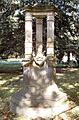
In 1909, a monument was built in Gotha to honor him, showing how important he was to German geography.
What Was Named After Him
Because of his significant work, several places, especially in the Arctic, were named after August Petermann. These include:
- Petermann Ranges (Antarctica)
- Petermann Island (Antarctica)
- Petermann Ranges (Australia)
- Petermann Peak
- Petermann Fjord
- Petermann Glacier
- Petermann Peninsula
- Kapp Petermann
There's even a crater on the Moon named Petermann crater! Petermann himself believed that map editors should have the privilege of naming new features, especially after important explorers or friends of geography.
The End of an Era
In 2003, the huge collection of maps, books, and archives from the Perthes publishing company (where Petermann worked) was bought by the German state of Thuringia. It is now kept at the University of Erfurt in Gotha.
In 2004, after 149 years of publication, the famous journal Petermanns Geographische Mitteilungen stopped being published. Today, the Perthes archives are housed in a modern building called Perthesforum in Gotha, where they can be studied by future generations.
Gallery
-
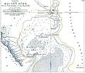
Petermann's map of the bay of Suez (1856)
-
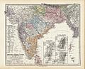
A page from Stielers Handatlas with credit, "Von A. Petermann." Many of his maps are credited in German as "Von A. Petermann." meaning, "By A. Petermann."
-
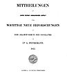
Front page of the 1st edition of Petermanns Geographische Mitteilungen (1855)
-
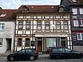
The house where Petermann was born: Neue Straße 3, Bleicherode
-
Petermann's grave at the cemetery of Gotha
-
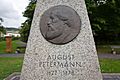
Memorial for August Petermann in his hometown Bleicherode
-
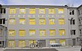
Perthesforum


See also
 In Spanish: August Petermann para niños
- Germania (ship, 1869)
