Barrington, New Hampshire facts for kids
Quick facts for kids
Barrington, New Hampshire
|
||
|---|---|---|
|
Town
|
||

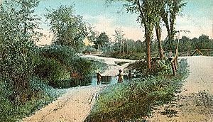
Tom Ham Brook c. 1910
|
||
|
||

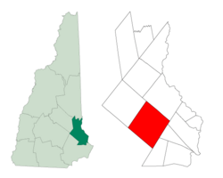
Location within Strafford County, New Hampshire
|
||
| Country | United States | |
| State | New Hampshire | |
| County | Strafford | |
| Settled | 1699 | |
| Incorporated | 1722 | |
| Villages |
|
|
| Area | ||
| • Total | 48.6 sq mi (125.9 km2) | |
| • Land | 46.6 sq mi (120.8 km2) | |
| • Water | 2.0 sq mi (5.1 km2) | |
| Elevation | 381 ft (116 m) | |
| Population
(2020)
|
||
| • Total | 9,326 | |
| • Density | 200/sq mi (77.2/km2) | |
| Time zone | UTC-5 (EST) | |
| • Summer (DST) | UTC-4 (EDT) | |
| ZIP code |
03825
|
|
| Area code(s) | 603 | |
| FIPS code | 33-03460 | |
| GNIS feature ID | 0873538 | |
Barrington is a town in Strafford County, New Hampshire, United States. It's a place where you can find woodlands, farms, and homes for people who travel to work in other towns.
In 2020, the town had a population of 9,326 people. This was an increase from 8,576 people in 2010.
Contents
History of Barrington
Barrington became an official town in 1722. It was named after Samuel Shute, who was the colonial governor of both Massachusetts and New Hampshire at the time. His brother was John Shute Barrington, 1st Viscount Barrington.
The town was originally formed from two land grants. One grant included all of what is now Strafford and most of present-day Barrington. The second grant was a two-mile-wide strip of land called New Portsmouth, or the Two Mile Streak. This strip was set aside to provide wood and homes for workers at the Lamprey River Iron Works, which was a company started in 1719 to help develop industries in the area.
Settling in Barrington was slow at first because the soil was very rocky. However, by 1810, Barrington had 3,564 residents. This made it the third-largest town in New Hampshire. Its main industry was smelting, which is a process of melting iron ore to get pure iron.
The Isinglass River and its smaller streams provided water power for different types of mills. These included grist mills (which ground grain into flour), fulling mills (which cleaned and thickened cloth), and saw mills (which cut wood).
In 1820, the area known as Strafford became its own separate town. This happened because it was too far for people in Strafford to travel to Barrington for town meetings. This change cut Barrington's land area in half.
In 1882, a writer named Reverend Alonzo Hall Quint described Barrington as one of the most beautiful towns in the state, known for its quiet scenery. The town has many attractive natural features, like rivers, brooks, waterfalls, and at least 14 ponds. There's even a hill called Beauty Hill, which is about 374 feet (114 meters) high.
Barrington is divided by the Calef Highway, also known as New Hampshire Route 125. This road is named after a state senator from the 1800s. His family also started a famous general store in 1869, which is still open today.
Geography of Barrington
Barrington covers a total area of about 48.6 square miles (125.9 square kilometers). About 46.6 square miles (120.8 square kilometers) of this is land, and 2.0 square miles (5.1 square kilometers) is water. This means that about 4% of the town's area is water.
The town's water comes from the Isinglass River and the Bellamy River. You can also find Swains Lake and Mendum's Pond in the southern part of town.
The highest point in Barrington is an unnamed hill near its western border. It stands about 610 feet (186 meters) above sea level. The highest named hill is Bumfagging Hill, which is about 601 feet (183 meters) high. All of Barrington is part of the Piscataqua River watershed, which means all its water eventually flows into the Piscataqua River and then to the ocean.
The main business area of Barrington is the village of East Barrington. This area is located where state routes 9 and 125 meet.
Neighboring Towns
Barrington shares its borders with several other towns:
- Rochester (to the northeast)
- Dover (to the east)
- Madbury (to the east)
- Lee (to the southeast)
- Nottingham (to the southwest)
- Northwood (to the west)
- Strafford (to the northwest)
Barrington's Population Over Time
| Historical population | |||
|---|---|---|---|
| Census | Pop. | %± | |
| 1790 | 2,470 | — | |
| 1800 | 2,773 | 12.3% | |
| 1810 | 3,564 | 28.5% | |
| 1820 | 1,610 | −54.8% | |
| 1830 | 1,895 | 17.7% | |
| 1840 | 1,845 | −2.6% | |
| 1850 | 1,752 | −5.0% | |
| 1860 | 1,963 | 12.0% | |
| 1870 | 1,581 | −19.5% | |
| 1880 | 1,497 | −5.3% | |
| 1890 | 1,408 | −5.9% | |
| 1900 | 1,208 | −14.2% | |
| 1910 | 900 | −25.5% | |
| 1920 | 616 | −31.6% | |
| 1930 | 613 | −0.5% | |
| 1940 | 780 | 27.2% | |
| 1950 | 1,052 | 34.9% | |
| 1960 | 1,036 | −1.5% | |
| 1970 | 1,865 | 80.0% | |
| 1980 | 4,404 | 136.1% | |
| 1990 | 6,164 | 40.0% | |
| 2000 | 7,475 | 21.3% | |
| 2010 | 8,576 | 14.7% | |
| 2020 | 9,326 | 8.7% | |
| U.S. Decennial Census | |||
According to the 2000 census, there were 7,475 people living in Barrington. These people lived in 2,756 households, and 2,075 of these were families. The population density was about 160 people per square mile (62 people per square kilometer).
About 38.8% of the households had children under 18 living with them. The average household had 2.71 people, and the average family had 3.07 people.
The population was spread out by age. About 27.5% of the people were under 18 years old. About 35.1% were between 25 and 44 years old, and 24.7% were between 45 and 64 years old. About 7.0% of the population was 65 years or older. The average age in town was 37 years.
Education in Barrington
The Barrington School District provides education for children from Pre-K through 8th grade. These students attend the Early Childhood Learning Center (ECLC), Barrington Elementary School, and Barrington Middle School.
For high school, students from Barrington go to schools in nearby towns. These schools include Dover High School, Coe-Brown Northwood Academy, Oyster River High School, or St. Thomas Aquinas High School.
Notable People from Barrington
Here are some well-known people who have connections to Barrington:
- John Buzzell (1766–1863), a Free Will Baptist preacher and writer.
- Paul Frase (born 1965), an American professional football player who played for teams like the New York Jets and Jacksonville Jaguars. He also helped start the Joshua Frase Foundation.
- Frank Jones (1832–1902), a brewer, hotel owner, and a U.S. congressman.
- Jillian Wheeler (born 1991), a singer, songwriter, and actress.
See also
 In Spanish: Barrington (Nuevo Hampshire) para niños
 | Delilah Pierce |
 | Gordon Parks |
 | Augusta Savage |
 | Charles Ethan Porter |


