
Barton, Maryland facts for kids
Quick facts for kids
Barton
|
|
|---|---|
_between_Railroad_Street_and_Eutaw_Street_in_Barton,_Allegany_County,_Maryland.jpg)
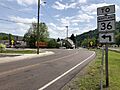
MD 935 through central Barton
|
|
| Etymology: Named for Barton-upon-Humber, England | |

Location of Barton, Maryland
|
|

Barton
Location in Maryland

Barton
Location in the United States

Barton
Location in North America
|
|
| Country | |
| State | |
| County | Allegany |
| Incorporated | 1900 |
| Named for | Barton-upon-Humber, North Lincolnshire, England |
| Area | |
| • Total | 0.21 sq mi (0.54 km2) |
| • Land | 0.21 sq mi (0.54 km2) |
| • Water | 0.00 sq mi (0.01 km2) |
| Elevation | 1,276 ft (389 m) |
| Population
(2020)
|
|
| • Total | 464 |
| • Density | 2,241.55/sq mi (866.61/km2) |
| Time zone | UTC-5 (Eastern (EST)) |
| • Summer (DST) | UTC-4 (EDT) |
| ZIP code |
21521
|
| Area codes | 301, 240 |
| FIPS code | 24-04625 |
| GNIS feature ID | 2390715 |
Barton is a small town in Allegany County, Maryland, United States. It's located in the Georges Creek Valley, a beautiful area known for its history. Barton is part of the larger Cumberland metropolitan area. In 2010, about 457 people lived here, and by 2020, the population grew slightly to 464.
Contents
History of Barton
How Barton Began
The story of Barton started in 1794 when a Methodist minister named William Shaw settled in the area. Later, in 1853, his son, William Shaw Jr., officially planned and laid out the town. He named it Barton after his father's hometown, Barton-upon-Humber in England.
Coal Mining Days
The discovery of coal nearby brought many new people to Barton. Settlers from Scotland, Ireland, and Germany came, hoping to find work in the mines. In 1853, the first shipment of coal was sent out on the newly built Georges Creek Railroad. For many years, coal mining was the main industry.
Over time, the deep coal mines were closed. They were replaced by strip mines, which dig coal from the surface. You can still see some of these mines from the town today. While coal was once king, most families in Barton now work in other types of jobs.
Early Mills and Industry
Besides coal, Barton also had early mills. The first gristmill (a mill for grinding grain into flour) was built on Moores Run. It used a water wheel for power. Another gristmill, called the Morrison Mill, was built south of Barton. There was also the Shaw Mill, a large stone mill built by the Shaw family. These mills were important for processing food for the community.
In the 1800s, many coal companies operated around Barton. These companies had special structures called coal tipples, which were used to load coal onto trains. One interesting piece of engineering was the Barton Coal Company's plane, a type of cable railway built in 1854. It helped move coal and operated for many years until 1898. Besides the big companies, many families also had small mines on their farms to sell coal locally.
Railroads and Modern Life
The Cumberland and Pennsylvania Railroad, which took over from the Georges Creek Railroad, opened a train station in Barton in 1889. This station was a key part of the town's transportation until it was taken down in the mid-1900s.
Today, Barton is a peaceful town with four churches and many volunteer groups. It has a lighted ball field, a playground, and two parks for everyone to enjoy. The town has faced challenges like floods and fires but has always recovered. Each year, Barton celebrates with a "Party in the Park," featuring crafts, food, entertainment, and a parade.
The historic Shaw Mansion was added to the National Register of Historic Places in 1985, recognizing its importance.
Geography
Barton covers a total area of about 0.22 square miles (0.54 square kilometers), and almost all of it is land.
Nearby Towns and Cities
Barton is close to several other communities, including:
- Cumberland
- Lonaconing
- Westernport
- Piedmont, West Virginia
- Luke
- Midland
- Keyser, West Virginia
- Frostburg
Transportation
The main way to travel to and from Barton is by road. Maryland Route 935 is the only state highway that goes directly through the town. It follows Legislative Road right through the center. MD 935 is actually the older path of Maryland Route 36, which now goes around the east side of town. Both ends of MD 935 connect back to MD 36. From MD 36, you can go north to Frostburg and Interstate 68, or south to Westernport.
Demographics
| Historical population | |||
|---|---|---|---|
| Census | Pop. | %± | |
| 1880 | 1,112 | — | |
| 1920 | 765 | — | |
| 1930 | 689 | −9.9% | |
| 1940 | 781 | 13.4% | |
| 1950 | 695 | −11.0% | |
| 1960 | 731 | 5.2% | |
| 1970 | 723 | −1.1% | |
| 1980 | 617 | −14.7% | |
| 1990 | 530 | −14.1% | |
| 2000 | 478 | −9.8% | |
| 2010 | 457 | −4.4% | |
| 2020 | 464 | 1.5% | |
| U.S. Decennial Census | |||
Population in 2010
According to the census from 2010, Barton had 457 people living in 195 households, with 132 of those being families. The town had about 2077 people per square mile. Most of the people living in Barton were White (98.0%). A small percentage were African American, Asian, or from two or more races. About 1.3% of the population identified as Hispanic or Latino.
Of the households, about 28.7% had children under 18 living with them. Many households (50.8%) were married couples living together. The average household had 2.34 people, and the average family had 2.83 people.
The average age in Barton was 39.9 years old. About 20.4% of residents were under 18, and 17.3% were 65 or older. The town had a fairly even split between males (51.0%) and females (49.0%).
Images for kids
-
MD 935 through the middle of Barton
_just_north_of_Railroad_Street_in_Barton,_Allegany_County,_Maryland.jpg)
See also
 In Spanish: Barton (Maryland) para niños
