Bean's Purchase, New Hampshire facts for kids
Quick facts for kids
Bean's Purchase, New Hampshire
|
|
|---|---|

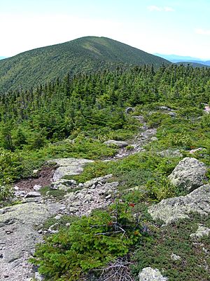
Carter Dome seen from Mt. Hight
|
|

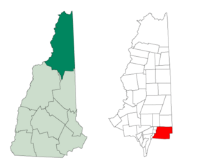
Location in Coös County, New Hampshire
|
|
| Country | United States |
| State | New Hampshire |
| County | Coös |
| Area | |
| • Total | 65.30 sq mi (169.12 km2) |
| • Land | 65.19 sq mi (168.85 km2) |
| • Water | 0.10 sq mi (0.27 km2) 0.16% |
| Elevation | 1,960 ft (600 m) |
| Population
(2020)
|
|
| • Total | 0 |
| Time zone | UTC-5 (Eastern) |
| • Summer (DST) | UTC-4 (Eastern) |
| Area code(s) | 603 |
| FIPS code | 33-007-04260 |
Bean's Purchase is a special area in Coös County, New Hampshire, United States. It is called a "township," but it's not like a regular town with its own government. It's an "unincorporated" part of the county.
This means Bean's Purchase is not part of any town. It has very limited or no self-government. The entire area is located within the beautiful White Mountain National Forest. As of the 2020 census, no one lives there.
Contents
History of Bean's Purchase
In 1851, the government of New Hampshire decided to sell some public lands. They chose James Willey to be the land commissioner. He was in charge of selling these lands.
Bean's Purchase was sold to Alpheus Bean in 1812. He bought the land for $1,025. The area he purchased was about 59,000 acres (239 square kilometers).
In 1927, a girl named Beth McKenzie was born in Bean's Purchase. She was the first child born within the area of the White Mountain National Forest. This forest was officially created in 1918. A brook in a nearby town, Berlin, is named Betty Brook in her honor.
Geography of Bean's Purchase
Bean's Purchase covers a total area of about 169.1 square kilometers (65.3 square miles). Only a very small part of this area, about 0.3 square kilometers (0.1 square miles), is water.
The middle of Bean's Purchase is in the valley of the Wild River. A large part of this area is also within the Wild River Wilderness. The western side of Bean's Purchase has tall mountains. These include Wildcat Mountain, the Carter mountains, and Mount Moriah.
The highest point in Bean's Purchase is the top of Carter Dome. It stands at 4,832 feet (1,473 meters) above sea level. The famous Appalachian Trail also goes through Bean's Purchase. It follows the high ridge of the Wildcat-Carter-Moriah mountains.
The rivers on the west side of this mountain ridge flow into the Peabody River. Both the Peabody and Wild rivers flow northeast. They are tributaries of the Androscoggin River. On the eastern edge of Bean's Purchase, you can find the summits of North Baldface, Mount Meader, and West Royce. The eastern slopes of these mountains are part of the Saco River watershed.
Neighboring Areas
Bean's Purchase shares borders with several other towns and grants:
- Shelburne (to the north)
- South Oxford, Maine (to the east)
- Chatham (to the southeast)
- Jackson (to the south)
- Pinkham's Grant (to the west)
- Green's Grant (to the west)
- Martin's Location (to the west)
- Gorham (to the northwest)
Population of Bean's Purchase
| Historical population | |||
|---|---|---|---|
| Census | Pop. | %± | |
| 1930 | 25 | — | |
| 1940 | 0 | −100.0% | |
| 1950 | 0 | — | |
| 1960 | 0 | — | |
| 1970 | 0 | — | |
| 1980 | 0 | — | |
| 1990 | 0 | — | |
| 2000 | 4 | — | |
| 2010 | 0 | −100.0% | |
| 2020 | 0 | — | |
| U.S. Decennial Census | |||
As of the 2020 census, the population of Bean's Purchase was zero. This means no one officially lives there. Bean's Purchase is considered part of the Berlin, NH-VT Micropolitan Statistical Area.
See also
 In Spanish: Bean's Purchase para niños
 | Tommie Smith |
 | Simone Manuel |
 | Shani Davis |
 | Simone Biles |
 | Alice Coachman |

