Bell Canyon facts for kids
Quick facts for kids Bell Canyon |
|
|---|---|

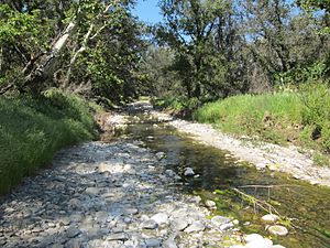
Bell Creek at Caspers Wilderness Park
|
|

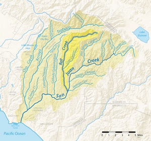
Map of the San Juan Creek watershed with Bell Canyon sub-watershed highlighted
|
|
| Other name(s) | Arroyo de las Campanas |
| Country | USA |
| State | California |
| Region | Orange County |
| Physical characteristics | |
| Main source | Bell Canyon, Santa Ana Mountains 4,000 ft (1,200 m) 33°39′51″N 117°28′22″W / 33.66417°N 117.47278°W |
| River mouth | San Juan Creek, outside San Juan Capistrano 113 ft (34 m) 33°32′3″N 117°33′17″W / 33.53417°N 117.55472°W |
| Length | 14.4 mi (23.2 km) |
| Basin features | |
| Tributaries |
|
Bell Canyon is a beautiful area in the Santa Ana Mountains of Orange County, California. It is home to Bell Creek, also called Bell Canyon Creek or Arroyo de las Campanas. This creek flows for about 14.4 miles (23.2 km) south until it meets San Juan Creek.
Bell Canyon is a very important part of the local environment. It is the second longest creek that flows into San Juan Creek. Most of Bell Canyon is protected wilderness. This includes parts of the Cleveland National Forest and Ronald W. Caspers Wilderness Park. The valley itself is very deep, more than 1,000 feet (300 m), and about 1 mile (1.6 km) wide. Smaller creeks like Dove Canyon, Crow Canyon, and Tick Creek join Bell Creek.
History of Bell Canyon
Early People in the Canyon
Native Americans called the Acjachemen (also known as Juaneño) lived in the Bell Canyon area for nearly 10,000 years. Archeologists have found proof of their long history here. It is said that these native people would hit rocks against boulders in the canyon. This made a ringing sound, which is how the canyon got its name. The word "Campanas" in "Arroyo de las Campanas" means "bells" in Spanish.
The way of life for the Acjachemen people changed when Spanish explorers and missionaries arrived. In 1776, the Mission San Juan Capistrano was built nearby. This mission was about 10 miles (16 km) from where Bell Creek meets San Juan Creek.
Land Ownership Changes
In 1841, a large piece of land that included Bell Canyon was granted to Pío Pico and Andrés Pico. This land was called 'Rancho San Onofre y Santa Margarita'. Later, more land was added, and it became the Rancho Santa Margarita y Las Flores.
Much of Bell Canyon was bought by Eugene Grant Starr in the late 1920s. This created a large area of undeveloped land. In 1973, this land became the 'Starr Ranch', managed by the National Audubon Society. It helps protect nature.
Protecting the Creek Today
Bell Creek still looks much like it did before the Spanish arrived. However, new towns like Coto de Caza have grown nearby. This has led to more urban runoff flowing into the creek. Urban runoff is rainwater that picks up pollution from streets and yards.
Even though this water often soaks into the ground before reaching San Juan Creek, it can still pollute the local groundwater. To help with this, pumps were installed in 2005 on Dove and Tick Creeks. These pumps remove extra surface water. This water is then cleaned and used for watering plants in homes. This helps reduce pollution and stops harmful invasive species of plants from growing.
How Bell Creek Flows
The Creek's Journey
Bell Creek starts high up in the Santa Ana Mountains. Its source is a network of canyons on the side of Los Pinos Peak. This peak is about 4,510 feet (1,370 m) tall. The creek's starting point is in the Cleveland National Forest.
Bell Creek flows through a deep canyon for about 4 miles (6.4 km). Then it turns southwest for another 1.5 miles (2.4 km). It flows near the edge of Rancho Santa Margarita. Along its path, Bell Creek gets water from smaller creeks. An unnamed creek joins it from the right side. Fox Creek, a slightly larger creek, enters from the left side.
Joining Other Creeks
The largest creek that flows into Bell Creek is Dove Canyon. It drains an area that includes homes and a golf course. Dove Canyon joins Bell Creek from the right side. Tick Creek also joins shortly after.
Bell Creek then flows south through a wider valley. Crow Canyon enters from the left side. By this point, Bell Creek becomes a wide, braided stream. This means it splits into many smaller channels that weave together. Most of its water flows underground here.
Finally, Bell Creek reaches San Juan Creek. This is about 7.5 miles (12.1 km) east of San Juan Capistrano. Bell Creek joins San Juan Creek on its right side. After this, San Juan Creek flows for another 14.7 miles (23.7 km) before reaching the Pacific Ocean at Dana Point.
The Bell Canyon Watershed
The Bell Canyon Creek watershed is shaped like an "L". A watershed is the area of land where all the water drains into a particular creek or river. This watershed is about 10 miles (16 km) long and 2 miles (3.2 km) wide at its widest point.
The Bell Canyon valley itself ranges from 2,600 feet (790 m) deep near its start to about 300 feet (91 m) deep near its end. The entire watershed covers about 26 square miles (67 km2). This is about 19% of the total San Juan Creek watershed.
Bell Canyon Creek is the second largest creek in the San Juan Creek watershed. It is second only to Trabuco Creek. Most of the Bell Canyon area is within the Cleveland National Forest and the Ronald W. Caspers Regional Park. However, the Dove Canyon area is a residential area in Rancho Santa Margarita.
Geology of the Canyon
How the Mountains Formed
The upper part of Bell Canyon is in the Santa Ana Mountains. These mountains are made of very old rocks, including igneous rock and metamorphic rock. These rocks are covered by layers of sedimentary rock and thin soil. The mountains started to rise about 5.5 million years ago.
The bottom of the upper Bell Canyon is made of a type of rock called the Bedford Canyon Formation. This formation includes different kinds of rocks like siltstone, limestone, and slate. There are also two small faults (cracks in the Earth's crust) that cross Bell Creek.
Ice Ages and River Changes
The flat areas along the lower canyon were formed by floods during the last Ice Age. This period was called the Wisconsinian glaciation. It happened between 70,000 and 10,000 years ago. During this time, sea levels around the world dropped a lot.
The climate in Southern California also changed. It became much colder and rainier. The small streams became powerful rivers. These rivers carved deep channels into the land as they flowed to the lower sea level.
When the Wisconsinian era ended, the climate became like it is today. The rivers went back to being small, seasonal streams. The sea level also rose again. This rise in sea level helped create river terraces, which are flat steps along the sides of the river valleys.
Water Flow Underground
The Bell Canyon Creek watershed has three main areas where water soaks into the ground differently.
- On the mountain slopes (about 65% of the watershed), water soaks in slowly. This causes a moderate amount of runoff during storms.
- In the deep valley floors, water soaks into the ground easily. It then flows underground into San Juan Creek. This area has many plants and trees near the creek. It produces little runoff during storms.
- In residential areas like Dove Canyon and Tick Creek, about 90% of the surface water flows into the streams as runoff. During storms, this runoff increases very quickly. This urban runoff continues to be a challenge for the Bell Canyon watershed.
Plants and Animals
Bell Canyon Creek has a wide, flat area where many plants grow. This area is called a riparian zone. It stretches from one side of the canyon to the other. This area has many trees and smaller plants.
Some of the common trees include the California Sycamore, Fremont Cottonwood, and Coast live oak. However, some non-native plants are causing problems. These invasive species, like Periwinkle and Ivy, are carried into the creek from nearby areas. They are replacing the native California plants that naturally grow there.
 | Dorothy Vaughan |
 | Charles Henry Turner |
 | Hildrus Poindexter |
 | Henry Cecil McBay |

