
Benson County, North Dakota facts for kids
Quick facts for kids
Benson County
|
|
|---|---|

Benson County Courthouse
|
|

Location within the U.S. state of North Dakota
|
|
 North Dakota's location within the U.S. |
|
| Country | |
| State | |
| Founded | March 9, 1883 (created) June 4, 1884 (organized) |
| Named for | Bertil W. Benson |
| Seat | Minnewaukan |
| Largest community | Fort Totten |
| Area | |
| • Total | 1,439 sq mi (3,730 km2) |
| • Land | 1,389 sq mi (3,600 km2) |
| • Water | 51 sq mi (130 km2) 3.5% |
| Population
(2020)
|
|
| • Total | 5,964 |
| • Estimate
(2022)
|
5,770 |
| • Density | 4.1445/sq mi (1.6002/km2) |
| Time zone | UTC−6 (Central) |
| • Summer (DST) | UTC−5 (CDT) |
| Congressional district | At-large |
Benson County is a county located in the state of North Dakota in the United States. In 2020, about 5,964 people lived there. The main town, or county seat, is Minnewaukan.
The county was created on March 9, 1883, by the government of the Dakota Territory. It was named after Bertil W. Benson, who was a lawmaker at that time. The county officially started its government on June 4, 1884.
A large part of the Spirit Lake Indian Reservation and the White Horse Hill National Game Preserve are found within Benson County.
Contents
Geography of Benson County
Much of the eastern border of Benson County is along the shore of Devils Lake. This is a special type of lake that doesn't flow into other rivers unless it overflows. The North Fork Sheyenne River also flows through the southwestern part of the county.
Benson County has rolling hills with many lakes, ponds, and small streams. The land gently slopes towards the east. The highest point in the county is about 1,624 feet (495 meters) above sea level, located on its western border. The county covers a total area of 1,439 square miles (3,727 square kilometers). About 1,389 square miles (3,597 square kilometers) is land, and 51 square miles (132 square kilometers) is water.
Neighboring Counties
These are the counties that share a border with Benson County:
- Towner County – to the north
- Ramsey County – to the northeast
- Nelson County – to the east
- Eddy County – to the southeast
- Wells County – to the southwest
- Pierce County – to the west
Main Roads
These are the most important highways that pass through Benson County:
 U.S. Highway 2
 U.S. Highway 281
 North Dakota Highway 19
 North Dakota Highway 20
 North Dakota Highway 57
Protected Natural Areas
Benson County is home to several protected natural areas, including:
- Buffalo Lake National Wildlife Refuge (part)
- Grahams Island State Park (part)
- Pleasant Lake National Wildlife Refuge
- Silver Lake National Wildlife Refuge (part)
- White Horse Hill National Game Preserve
- Volk National Wildlife Refuge
- Wood Lake National Wildlife Refuge
- Wurgler National Wildlife Refuge
Lakes in Benson County
Here are some of the lakes found in Benson County:
- Broken Bone Lake
- Cranberry Lake
- Free Peoples Lake
- Horseshoe Lake
- Lake Murie
- Lake Yri
- Long Lake
- Sand Lake
- Shin Bone Lake
- Spring Lake
- Stink Lake
- Stony Lake
- Wood Lake
People and Population
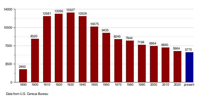
The number of people living in Benson County has changed over the years. Here's how the population has grown and shrunk:
| Historical population | |||
|---|---|---|---|
| Census | Pop. | %± | |
| 1890 | 2,460 | — | |
| 1900 | 8,320 | 238.2% | |
| 1910 | 12,681 | 52.4% | |
| 1920 | 13,095 | 3.3% | |
| 1930 | 13,327 | 1.8% | |
| 1940 | 12,629 | −5.2% | |
| 1950 | 10,675 | −15.5% | |
| 1960 | 9,435 | −11.6% | |
| 1970 | 8,245 | −12.6% | |
| 1980 | 7,944 | −3.7% | |
| 1990 | 7,198 | −9.4% | |
| 2000 | 6,964 | −3.3% | |
| 2010 | 6,660 | −4.4% | |
| 2020 | 5,964 | −10.5% | |
| 2022 (est.) | 5,770 | −13.4% | |
| U.S. Decennial Census 1790-1960 1900-1990 1990-2000 2010-2020 |
|||
2020 Census
According to the census in 2020, there were 5,964 people living in Benson County.
2010 Census
In 2010, the census counted 6,660 people in the county. The population density was about 4.8 people per square mile.
The people living in Benson County were made up of different groups:
- 55.0% were American Indian
- 43.4% were white
- 0.2% were from other races
- 1.4% were from two or more races
About 1.2% of the population was of Hispanic or Latino background.
The average age of people in Benson County was 31.6 years.
Population Changes Over Time
This chart shows how the population of Benson County has changed from 1890 to 2022.
Communities in Benson County
Benson County has several cities, towns, and smaller communities. The largest community is Fort Totten, followed by Leeds, Maddock, and the county seat, Minnewaukan. There are nine cities in the county.
The largest township is Mission Township, with 935 people. It's on the south shore of Devils Lake and is popular for vacations. It's also home to the Spirit Lake Casino and Resort and is part of the Spirit Lake Indian Reservation.
Cities
Census-designated place
Unincorporated Communities
These are smaller communities that are not officially organized as cities or towns:
Townships
Townships are smaller local government areas within the county:
- Albert
- Arne
- Aurora
- Beaver
- Broe
- Butte Valley
- East Fork
- Eldon
- Esmond
- Hesper
- Impark
- Iowa
- Irvine
- Isabel
- Knox
- Lake Ibsen
- Lallie
- Leeds
- Lohnes
- McClellan
- Minco
- Mission
- Normania
- North Viking
- Oberon
- Pleasant Lake
- Rich Valley
- Riggin
- Rock
- South Viking
- Twin Lake
- Twin Tree
- Warwick
- West Antelope
- West Bay
- Wood Lake
- York
Education
Here are the school districts that serve students in Benson County:
K-12 School Districts
These districts offer schooling from kindergarten through 12th grade:
- Dakota Prairie Public School District 1
- Devils Lake Public School District 1
- Fort Totten Public School District 30
- Harvey Public School District 38
- Leeds Public School District 6
- Maddock Public School District 9
- Minnewaukan Public School District 5
- New Rockford-Sheyenne Public School District 2
- North Star School District
- Rugby Public School District 5
- Warwick Public School District 29
Elementary School Districts
This district focuses on elementary education:
- Oberon Public School District 16
See also
 In Spanish: Condado de Benson para niños
