
Bills Peak facts for kids
Quick facts for kids Bills Peak |
|
|---|---|

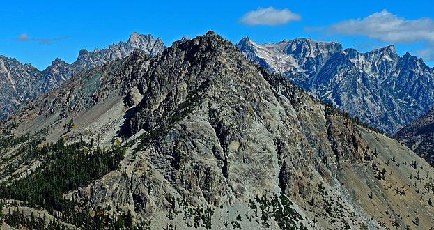
Southwest aspect
|
|
| Highest point | |
| Elevation | 6,917 ft (2,108 m) |
| Prominence | 1,077 ft (328 m) |
| Isolation | 2.61 mi (4.20 km) |
| Parent peak | Earl Peak (7,036 ft) |
| Geography | |

Bills Peak
Location in Washington (state)

Bills Peak
Location in the United States
|
|
| Location | Kittitas County / Chelan County Washington, U.S. |
| Parent range | Wenatchee Mountains Cascade Range |
| Topo map | USGS Mount Stuart |
| Climbing | |
| Easiest route | class 3 scrambling |
Bills Peak is a mountain in Washington state. It stands about 6,917 feet (2,108 meters) tall. This peak is located right on the border between Kittitas County and Chelan County.
Bills Peak is the tenth-highest point in the Teanaway area. This area is part of the Wenatchee Mountains. The mountain is near the Alpine Lakes Wilderness area. It is also on land managed by the Wenatchee National Forest.
Water from the peak flows south into the Teanaway River. It also flows north into Ingalls Creek. Ingalls Creek is part of the Wenatchee River system. From the top of Bills Peak, you can see amazing views. These include the huge Mount Stuart and the Stuart Range.
The mountain was named after William Noble "Bill" Prater. He was a mountaineer and farmer. Bill Prater lived in nearby Ellensburg.
Contents
Meet Bill Prater
Bill Prater (1926–2010) was a famous climber. He was the first person to climb several peaks. These include Argonaut Peak and Sherpa Peak in 1955. He also climbed Mount Kennedy in Canada in 1965.
A Winter Climb and Rescue
In December 1960, Bill Prater and his younger brother Gene were climbing Bills Peak. They were with two other people. As they got close to the top, a snowslide happened. The snowslide carried the Prater brothers down the mountain. Bill was hurt and needed help. A rescue team came to get him.
Inventing Modern Snowshoes
In the early 1970s, Bill and Gene Prater invented something new. They created the modern aluminum snowshoe. These snowshoes helped people walk on deep snow. Bill sold them through his company, "Sherpa Snowshoes." They became very popular.
Understanding the Climate
Bills Peak is located east of the Cascade Range. This means the weather here is a bit drier. It gets less rain and snow than areas to the west.
Summer Weather
Summers can be warm on Bills Peak. Sometimes, there are thunderstorms. Usually, there are clear skies in summer. This is because of high pressure systems over the Pacific Ocean.
Winter Weather
Most weather comes from the Pacific Ocean. It moves east towards the Cascade Mountains. When weather fronts hit the tall Cascade peaks, they are forced upwards. This causes them to drop their moisture. This moisture falls as rain or snow on the western side of the mountains. This process is called Orographic lift. Because of this, the eastern slopes, like Bills Peak, get less precipitation. Winters are often cloudy.
Exploring the Geology
The Alpine Lakes Wilderness has very rugged land. You can see jagged peaks and ridges. There are also deep valleys carved by glaciers. Huge granite walls are common. Over 700 mountain lakes dot the area.
How Mountains Formed
The Cascade Range formed over millions of years. This started in the late Eocene Epoch. The North American Plate slowly moved over the Pacific Plate. This caused many volcanic eruptions. Also, small pieces of the Earth's crust, called terranes, joined together. This helped create the North Cascades about 50 million years ago.
Ice Age and Valleys
About two million years ago, during the Pleistocene period, glaciers covered the land. These huge ice sheets moved back and forth many times. They carved and shaped the landscape. The last glaciers in the Alpine Lakes area started to melt about 14,000 years ago. They were gone from the area by 10,000 years ago.
The river valleys in this area have a "U"-shape. This shape was created by these ancient glaciers. The mountains and deep valleys of the Alpine Lakes Wilderness were formed by two main things:
- Uplift: When the Earth's crust pushes upwards.
- Faulting: When cracks in the Earth's crust cause sections to move.
- Glaciation: The action of ice sheets.
Gallery
-
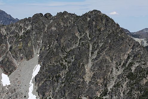
South aspect from Iron Peak, with Stuart Range in back
-
West aspect, from Teanaway Peak aka Genes Peak


