
Bletchley facts for kids
Quick facts for kids Bletchley |
|
|---|---|
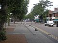
 Queensway, the main shopping street in Bletchley. |
|

Bletchley
|
|
| Population | 37,114 (2011 census) |
| OS grid reference | SP872336 |
| • London | 43 miles (69 km) |
| Civil parish |
|
| District |
|
| Unitary authority |
|
| Ceremonial county | |
| Region | |
| Country | England |
| Sovereign state | United Kingdom |
| Post town | MILTON KEYNES |
| Postcode district | MK1-3 |
| Dialling code | 01908 |
| Police | Thames Valley |
| Fire | Buckinghamshire |
| Ambulance | South Central |
| EU Parliament | South East England |
| UK Parliament |
|
Bletchley is a town located in Milton Keynes, Buckinghamshire, England. It's in the southwest part of the city. The town is divided into two main areas called civil parishes: Bletchley and Fenny Stratford and West Bletchley. In 2011, the total population of these areas was 37,114 people.
Bletchley is most famous for Bletchley Park. This was the secret headquarters where Britain's World War II codebreaking teams worked. Today, it's a popular place for tourists to visit. The National Museum of Computing is also located at Bletchley Park.
Contents
History of Bletchley
How Bletchley Started
The name Bletchley comes from an old Anglo-Saxon phrase meaning "Blæcca's clearing." It was first written down in records during the 12th century. Back then, it was called Bicchelai. Later, its name changed to Blechelegh and then Blecheley.
Near Bletchley, there was an old Roman-British town called Magiovinium. This town was built along Watling Street, an important Roman road.
Bletchley began as a small village next to Fenny Stratford. Fenny Stratford used to be more important. However, Fenny Stratford started to decline after the English Civil War in the 1600s.
The Railway Arrives
The arrival of the London and Birmingham Railway in 1838 changed everything for Bletchley. This railway is now part of the West Coast Main Line. Even more important were the new railway lines that connected Bletchley to Bedford (in 1846) and Buckingham (in 1850). These lines later became part of the "Varsity Line" between Oxford and Cambridge.
Because of these railway connections, Bletchley railway station became a very busy place. Bletchley grew quickly and became more important than Fenny Stratford.
By 1884, Bletchley was still a small village around its church. There was also a small group of houses near a chapel and a pub. These areas are now known as Old Bletchley and Far Bletchley. Fenny Stratford was still the main settlement at that time.
Brick-Making in Bletchley
The Bletchley area has a lot of a special type of clay called Oxford Clay. This clay has been used to make bricks for a long time. Brick-making started in the area around 1897. The Bletchley Brickworks factory closed in September 1990.
Bletchley Grows in the 20th Century
As the railway brought more people, Bletchley and Fenny Stratford grew together. In 1895, Fenny Stratford became an urban district. Bletchley joined it in 1898. By 1911, the combined population was 5,166. The local council changed its name from Fenny Stratford Urban District to Bletchley Urban District.
In 1933, a local newspaper, the Bletchley Gazette, started a campaign for a "Bigger, Better, Brighter, Bletchley." After World War II, Bletchley Council wanted the town to grow even more. Its population was 10,919 in 1951.
By 1952, the council agreed to welcome people and businesses from London, which had been damaged by bombs during the war. This growth continued through the 1950s and 1960s. New industrial areas like Mount Farm and Denbigh were built, and businesses like Marshall Amplification moved there.
Bletchley Road, the main street, was changed to Queensway after a royal visit in 1966. It became a wide high street with shops and businesses. By 1971, the population of the Bletchley Urban District was 30,642.
Bletchley as Part of Milton Keynes
In the early 1960s, there were plans to build a new city in North Buckinghamshire. Bletchley hoped to be the center of this new city. However, when Milton Keynes was officially created in 1967, Bletchley was at its southern end. The plan for Milton Keynes in 1971 placed the new city center, Central Milton Keynes, four miles north. Bletchley became a suburb.
In the early years of Milton Keynes, Bletchley was the main shopping area. The Brunel Shopping Centre was built in the early 1970s, changing the look of Queensway. But when the new Central Milton Keynes Shopping Centre was built, Bletchley's shops became less popular.
In March 2021, Bletchley received good news. The Bletchley and Fenny Stratford Town Deal Board successfully got £22.7 million from the UK Government's "New Towns Deal." Most of this money will be used to improve jobs, skills, and connections in Central Bletchley.
Bletchley Park: The Secret Codebreaking Site

Bletchley Park is located in the Church Green area of West Bletchley. During the Second World War, it was the secret home of the Government Code and Cypher School. Here, brilliant minds like Alan Turing worked to break the German Enigma code. They also solved another secret code using early computers called Colossus.
Today, Bletchley Park is a museum. Visitors can learn about the amazing work done there. Some parts of the park grounds have been sold for building houses.
Wilton Hall
Wilton Hall is a building near Bletchley Park. It was built in 1943 as part of the Bletchley Park estate. The government used it for meetings during the day and as a place for music and dancing at night.
After World War II, Wilton Hall remained open. Famous musicians like Lulu and The Rolling Stones performed there. The building closed in 2019 and was planned to be torn down. However, local people and the Member of Parliament (MP) wanted to save it because of its history. In 2020, it was sold to new owners who refurbished it, and it reopened in 2022.
Bletchley's Local Areas
Bletchley is divided into two main local government areas called civil parishes: Bletchley and Fenny Stratford and West Bletchley.
The districts in the Bletchley and Fenny Stratford parish include:
- Brickfields (with the Blue Lagoon)
- Central Bletchley
- Denbigh
- Eaton Manor
- Fenny Stratford
- Granby
- Manor Farm
- Mount Farm
- Newton Leys
- Water Eaton (including "Lakes Estate")
In 2011, this parish had a population of 15,313.
The West Bletchley parish covers the part of Milton Keynes that is south of Standing Way (A421), west of the West Coast Main Line railway, and north of the Varsity Line railway. In 2011, this parish also had a population of 15,313. The areas in this parish are:
- Church Green (including Bletchley Park)
- Far Bletchley
- Old Bletchley
- West Bletchley (district)
- Whaddon (an area around Whaddon Way)
In 1961, the Bletchley parish had 17,095 people. On April 1, 1974, the parish was removed and became part of the Milton Keynes district.
Getting Around Bletchley: Transport
Trains
Bletchley railway station is on Sherwood Drive. It serves both the West Coast Main Line and the Bletchley-Bedford Marston Vale Line. The Marston Vale Line was once part of the Oxford-Cambridge Varsity Line, which closed in 1967.
However, a big project called East West Rail is rebuilding and reopening the line west of Bletchley to Bicester Village via Winslow. The line from Bicester Village to Oxford is already open. Eventually, trains are planned to go all the way to Cambridge.
Roads
Several major roads in Milton Keynes serve Bletchley:
- Watling Street (known as the V4 between Denbigh North and Stony Stratford)
- V7 Saxon Street (connects Central Bletchley to the rest of the city)
- H8 Standing Way (A421) (goes west towards Buckingham and the M40, and east towards Bedford and the M1)
- The A5 runs along the east side of Fenny Stratford, connecting it to the city center.
- The A4146 southern bypass serves Water Eaton, Newton Leys, and Fenny Stratford.
Watling Street is an ancient Roman road that used to connect Dover and Wroxeter. It runs through Fenny Stratford and on through Stony Stratford.
Buses
Bletchley is a main hub for bus services in southern Milton Keynes. Several bus companies serve the town, including Arriva, Z&S Transport, Red Rose, and Star Travel.
The main bus station in Bletchley is on South Terrace, in Central Bletchley. Milton Keynes City Council also has an on-demand bus service called "MK Connect" that covers the whole area, including Bletchley.
Sports and Fun in Bletchley
Bletchley has a football club called Milton Keynes Irish. It also has a rugby union club, Bletchley RUFC. Both clubs play at Manor Fields, just south of Fenny Stratford.
Bletchley Leisure Centre was finished in 2009. It replaced an older building from the 1970s.
Stadium MK, the home of Milton Keynes Dons football team, is at the northern edge of Bletchley. This area also has the "MK1" shopping center. It includes shops, restaurants, and an Odeon cinema.
Bletchley's Built-Up Area
For the 2011 census, the Office for National Statistics (ONS) defined a "built up area sub-division" for Bletchley. This area is west of the A5 and south of the A421. In 2011, this area had a population of 37,114 people.
For the 2001 census, the ONS used a larger "urban sub-area" for Bletchley. This area was similar to the old Bletchley Urban District Council boundaries. It also included parts of Shenley Brook End Civil Parish, like Furzton, Emerson Valley, Tattenhoe, and Snelshall. In 2001, this larger area had a population of 47,176.
Images for kids
-
Queensway, the main shopping street in Bletchley.
-
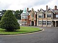
The main house at Bletchley Park
See also
 In Spanish: Bletchley para niños
