History of Milton Keynes facts for kids
This article tells the story of Milton Keynes, from its very first human settlements to the modern city it is today. Milton Keynes was officially started in 1967. It's the biggest town and only city in Buckinghamshire. In 2021, over 256,000 people lived in its urban area.
Contents
- How Milton Keynes Began
- Ancient Times and Early People
- Roman Britain
- Anglo-Saxon Period
- Norman Conquest and Medieval Times
- Early Modern Britain
- Bletchley Park
- Bletchley in the 20th Century
- Plans for a New City in the 1960s
- Designing a City for 250,000 People
- Future Development Plans
- Milestones Since 1967
How Milton Keynes Began
In the 1960s, the UK government needed to find places for more people to live. London was getting very crowded. They decided to create a new type of large town, called a 'new city', in the South East of England.
Since the 1950s, some people from London had already moved to Bletchley. Studies in the 1960s showed that north Buckinghamshire was a good spot for a huge new city. This new city would include the existing towns of Bletchley, Fenny Stratford, Stony Stratford, and Wolverton. It was planned to be the biggest new town ever, aiming for 250,000 people. The area was about 21,883 acres (8,856 hectares).
The name 'Milton Keynes' came from a small, old village already in the area. Most of the land was farmland and small villages. Before building started, every part of the area was carefully checked by archaeologists. This helped uncover a rich history of human life stretching back thousands of years.
From 1967 to 1992, the Milton Keynes Development Corporation was in charge of building the city. Many famous British architects and landscape designers helped create this special place. Unlike older new towns, most of Milton Keynes was built with private money. However, the Development Corporation made sure all buildings followed strict design rules.
Ancient Times and Early People
Long, long ago, this area was covered by a deep sea. One amazing fossil found here is an ichthyosaur (an ancient sea reptile) from Caldecotte. You can see it in the central library.
Humans started living here around 2000 BCE (about 4,000 years ago). They mostly lived near the River Ouse and River Ouzel. Archaeologists have found several burial sites from 2000 BCE to 1500 BCE. The oldest signs of people were found at Blue Bridge. Here, they found flint tools from the Middle Stone Age.
In the same area, a very large round house (18 meters wide) was found. It dates back to the Late Bronze Age or Early Iron Age, around 700 BCE. Other digs in the Blue Bridge area found seven more settlement sites, used until about 100 BCE.
The Milton Keynes Hoard
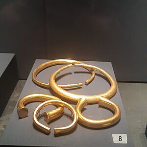
The area that became Milton Keynes was quite wealthy in ancient times. The Milton Keynes Hoard is one of the biggest collections of Bronze Age gold jewellery ever found in Britain. It weighs about 2.2 kg (nearly 5 pounds)! The British Museum said it "seems to flaunt wealth."
It was found in September 2000 at Monkston, near the original Milton Keynes village. The hoard includes two Bronze Age gold torcs (necklaces) and three gold bracelets. They were hidden in a clay pot.
Roman Britain
Before the Roman conquest of Britain in 43 CE, the Catuvellauni tribe lived here. They controlled the area from their hillfort at Danesborough, near Woburn Sands. When the Romans arrived, the area became very successful.
A major Roman road, called Iter II (later known as Watling Street), ran right through the area. This road led to a Roman town called Magiovinium at Fenny Stratford. A "superb example" of the first type of coin used in Britain was found here. It was a gold coin from the mid-second century BCE.
The remains of a large Romano-British villa were found at Bancroft Park. It even had under-floor heating and mosaic floors. Further digs showed that this area was lived in for 2,000 years, from the Late Bronze Age to the early Saxon period. Iron Age burial items found here included jewellery and nice pottery. Other Roman settlements were found at Stanton Low, Woughton, and Wymbush. People also worked with bronze and made pottery at Caldecotte and Wavendon Gate. Many iron-working sites were also found.
Anglo-Saxon Period
Most Roman sites were left empty by the fifth century. The farmland turned back into wild scrub and woodland. The Anglo-Saxons arrived in the sixth century and began clearing the land again. Names like Bletchley ('Blaeca's clearing') and the Shenleys ('Bright clearing') come from this time.
Large Anglo-Saxon settlements have been found at Pennyland and near Milton Keynes village. Their burial grounds were found at Newport Pagnell, Shenley, and Tattenhoe.
The Domesday Book of 1086 is the first written record of many settlements. It lists places like Bertone (Broughton), Calvretone (Calverton), Linforde (Great Linford), and Wluerintone (Wolverton).
Secklow Mound, an ancient meeting place for the Sigelai Hundred (an old administrative area), has been found and rebuilt. It's on the highest land in the central area, just behind the Central Library in modern Central Milton Keynes. Newport Pagnell, started in the early 10th century, was the main market town for the area.
Norman Conquest and Medieval Times
After the Norman conquest in 1066, the de Cahaignes family owned the manor of Middleton from 1166 to the late 1200s. The village became "Middleton de Cahaignes," which slowly changed over centuries to "Milton Keynes." There are Norman motte and bailey castle sites in Old Wolverton and Shenley Church End.
Stony Stratford and Fenny Stratford became market towns on Watling Street in the late 1100s or early 1200s.
By the early 1200s, North Buckinghamshire had several religious houses. Bradwell Abbey (1154) is inside modern Milton Keynes. Many old medieval paths to these sites still exist. They are now part of the Redway network for bikes and walkers.
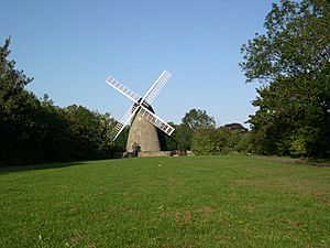
Britain's earliest discovered windmill was in Great Linford. Its large oak base supports were found and dated to the first half of the 13th century. The stone tower mill near Bradwell was built in 1815.
Only one medieval manor house still stands: the 15th-century Manor Farmhouse in Loughton. The oldest surviving house is Number 22, Milton Keynes (village). It was the home of the bailiff (manager) of Bradwell manor.
Early Modern Britain
Enclosures
Most of the eighteen medieval villages in Milton Keynes still exist today. But some, like Old Wolverton, are only seen as old field patterns. Old Wolverton became a deserted village because landlords changed large open fields into smaller enclosed ones. They turned farmland into pastures for animals.
By 1654, the Longville family had completely enclosed the parish. With the end of the feudal system, peasants lost their land and rights to farm or graze animals. They had to find other work or starve. So, Old Wolverton went from about thirty peasant families in the mid-1500s to almost none within a century. There are also deserted village sites in Tattenhoe and Westbury (Shenley Wood).
Turnpike Roads
Some important roads crossed the area where the new city was built. The most important was Watling Street, which ran between London and Chester. Another route went from Oxford to Cambridge through Stony Stratford, Wolverton, and Newport Pagnell.
These roads were often muddy and hard to use in winter. The Hockliffe – Dunchurch part of Watling Street became a paved Turnpike in 1706. Turnpikes were roads where you paid a toll to use them. This helped improve the roads.
Turnpikes greatly helped the economies of Fenny Stratford and Stony Stratford. In the stage coach era, Stony Stratford was a major stop for coaches. Over 30 coaches a day stopped there in the early 1800s. This traffic suddenly ended in 1838 when the London and Birmingham Railway opened through nearby Wolverton.
Grand Junction Canal
The Grand Junction Canal was built through the area between 1793 and 1800. There were wharfs (loading areas) along the canal in Fenny Stratford, Great Linford, Bradwell, and Wolverton. The canal didn't go through Newport Pagnell, but a branch was dug to it in 1817.
Trade along the canal helped the local economy. A large brickworks was built near the canal in Great Linford. You can still see two bottle kilns and the clay pits there.
London and Birmingham Railway, Wolverton and New Bradwell New Towns
The London and Birmingham Railway brought even bigger changes. The coach business in Stony Stratford collapsed, hurting many businesses. Luckily, Wolverton was the halfway point on the rail route. Engines were changed here, and passengers could get food and drinks.
Wolverton railway works was built here, creating jobs for thousands of people. Between 1840 and 1880, new towns were built in New Bradwell and Wolverton (about 2 km east of the original deserted village) to house these workers. A narrow gauge railway was built to Newport Pagnell in 1866. The Wolverton and Stony Stratford Tramway ran to Stony Stratford from 1888 to 1926.
Bletchley also became an important railway town. It was on the junction of the London and Birmingham railway with the Bedford branch. Bletchley grew and took over Fenny Stratford, which was its parent village.
Bletchley Park
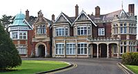
Bletchley Park is a former private estate in Old Bletchley. It was a very important secret intelligence site during World War II. Today, it's home to museums about Cryptography (code-breaking) and Computing.
Because it was conveniently located at a railway junction, Bletchley Park (code-named Station X) became the main code-breaking center for the Allied forces during World War II. They deciphered codes and ciphers from several Axis powers, most famously the German Enigma machine. Colossus, the world's first programmable electronic digital computer, was used here to help break codes. The high-level intelligence from Bletchley Park, called Ultra, is often credited with helping the Allies win the war faster.
Bletchley in the 20th Century
By 1911, the population of Bletchley and Fenny Stratford was 5,166. The local council changed its name to Bletchley Urban District. By 1926, the settlements started to merge. In 1933, the local newspaper started a campaign for a "Bigger, Better, Brighter, Bletchley."
After World War II, Bletchley Council wanted to grow. By 1952, they agreed to take people and businesses from bombed-out parts of London. This continued through the 1950s and 1960s. Businesses like Marshall Amplification moved to new industrial areas. Bletchley Road became the new high street, called Queensway. By 1971, the population of Bletchley was 30,642.
Bletchley wanted to be the center of the new city, but it wasn't chosen. The 1970 plan for Milton Keynes put Central Milton Keynes on a new site four miles north. Bletchley became a suburb.
Plans for a New City in the 1960s
In the 1960s, the government decided to build more new towns in South East England. These towns would help with London's growing population.
In 1964, a government study suggested a "new city" near Bletchley. A 1965 study proposed that this new city would include Bletchley, Stony Stratford, and Wolverton. It was planned to be the biggest new town yet, with a target population of 250,000.
The Housing Minister, Anthony Greenwood, officially announced the new town on January 23, 1967. The chosen area was about 21,870 acres (8,850 hectares). The name "Milton Keynes" was also announced, taken from the existing village of Milton Keynes in the area. The site was chosen because it was roughly equal distance from London, Birmingham, Leicester, Oxford, and Cambridge. With its large target population, Milton Keynes was meant to become a city one day. It officially became a city in August 2022.
When Milton Keynes was created, about 40,000 people already lived in the area. The land was divided among five local councils.
Existing Villages and Their Stories
In 1967, the area outside the four main towns (Bletchley, Newport Pagnell, Stony Stratford, Wolverton) was mostly farmland. But it also had many charming villages and hamlets. These included Bradwell village, Broughton, Caldecotte, Great Linford, Loughton, Milton Keynes Village, New Bradwell, Shenley Brook End, Shenley Church End, Simpson, Stantonbury, Tattenhoe, Tongwell, Walton, Water Eaton, Wavendon, Willen, Great and Little Woolstone, and Woughton on the Green. All these places had rich spoken histories, which have been recorded.
Designing a City for 250,000 People
After the plan for Milton Keynes was published, the government put the Milton Keynes Development Corporation (MKDC) in charge. They wanted to make sure the city was built as planned. The goals for the new city were:
- Lots of opportunities and choices for people.
- Easy ways to move around and access places.
- Good ways to communicate.
- A balanced and varied city.
- An attractive city.
- Public involvement and awareness.
- Smart use of resources.
The designers wanted to learn from mistakes made in earlier new towns. They also wanted to bring back the ideas of the Garden City (cities with lots of green space). They created the special grid roads that run between different areas. They also designed the Redway system of separate paths for bikes and walkers. They planted millions of trees and created many lakes and parks.
Central Milton Keynes was not meant to be a traditional town center. Instead, it was a business and shopping area that added to the smaller local centers in most of the grid squares. This plan was different from other new towns. It aimed for many types of industries and different housing styles. The grid plan was inspired by an urban thinker named Melvin M Webber. He believed that with modern communication, cities didn't need to be tightly packed. He thought cities should allow people to travel easily, creating "community without closeness."
Urban Design
Milton Keynes's unique plan and large size got international attention. Early parts of the city were designed by famous architects like Lord Norman Foster. The Development Corporation itself had many talented young architects. Their modern designs were often shown in architectural magazines.
"City in the Forest"
The original plan was to create a 'forest city'. The foresters planted millions of trees from their own nursery. By 2006, the urban area had 20 million trees! After the Development Corporation closed, the beautiful landscapes along the grid roads and in the major parks were given to the Milton Keynes Parks Trust. This is a charity that looks after the green spaces. It's funded by renting out commercial properties, which is a unique way to pay for park upkeep.
Public Art
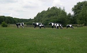
The Development Corporation had a big public art program. Over 50 artworks were created, and most are still there. This program had two parts. One part involved the local community, like Liz Leyh's famous Concrete Cows. These concrete Friesian cows have become an unofficial symbol of the city. The other part was more abstract art, like Lilliane Lijn's Circle of Light in the Central Milton Keynes shopping centre.
Demographics
Milton Keynes is unusual for a new town because most homes (about 80%) are privately owned. This was due to the political situation. Earlier new towns were mostly built for social housing (rented from the government). Milton Keynes started that way, but it was mostly built under governments that wanted more private involvement.
Future Development Plans
In January 2004, the government announced plans to expand Milton Keynes. They proposed that the population should double in the next 20 years. A group called English Partnerships was put in charge. They created a local group, the 'Milton Keynes Partnership', to manage the growth.
Their plans for expansion moved away from the grid squares. They focused on large, mixed-use developments with more homes in each area. This included big expansions to the east (Broughton and Brooklands) and west (Whitehouse and Fairfields). They also planned to make the city center more dense. As of April 2020, the Milton Keynes Partnership still exists, working with Milton Keynes Council.
Milestones Since 1967
1960s
- 1961: The population of the areas that would become Milton Keynes was 52,931.
- 1967: Milton Keynes is officially designated as a New Town.
- 1969: The Open University moves to its new headquarters in Walton Hall.
1970s
- 1970: The first part of the new city's grid road system opens. The Stables holds its first concert.
- 1971: The first major housing project by MKDC is completed (Galley Hill, Stony Stratford). The population of the future Milton Keynes District is 65,925.
- 1974: Stantonbury Campus opens. The first major grid road (V8 Marlborough Street) connects Bletchley to Stantonbury. Work begins on the Shopping Building. The first balancing lake (Willen Lake) is finished. The Borough of Milton Keynes is created.
- 1975: The first office building in Central Milton Keynes (Lloyds Court) opens.
- 1979: The first concert at Milton Keynes Bowl takes place. Margaret Thatcher opens the Shopping Building.
1980s
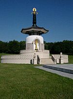
- 1980: The A5D opens, bypassing Watling Street. The Peace Pagoda is dedicated at Willen.
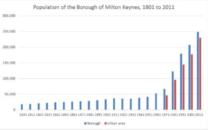
- 1981: Homeworld 81 (a housing exhibition) takes place. The Central Library and Willen Hospice open. The population of the Borough of Milton Keynes is 122,351.
- 1982: Milton Keynes Central railway station officially opens.
- 1983: The Caldecotte balancing lake is ready.
- 1984: The A421 road connects to the M1 motorway. Milton Keynes General Hospital opens (now Milton Keynes University Hospital).
- 1985: Britain's first multiplex cinema, The Point, opens.
- 1987: Woughton Marina opens.
- 1989: Furzton balancing lake is completed. The Bradwell aqueduct (the first aqueduct on the Grand Union Canal in over 100 years) is built. The Milton Keynes Coachway opens, the first of its kind in the UK.
1990s
- 1991: The population of the Borough of Milton Keynes is 176,304. The Church of Christ the Cornerstone is completed. De Montfort University opens its Milton Keynes campus.
- 1992: The Milton Keynes Development Corporation is closed down. Kingston District Centre opens. HMP Woodhill prison opens.
- 1994: Westcroft district centre opens.
- 1996: National Hockey Stadium opens.
- 1997: The District of Milton Keynes becomes the "Borough of Milton Keynes," a unitary authority (meaning it manages its own local services).
- 1999: Milton Keynes Theatre, Art Gallery, and a new Visitor Centre open.
2000s
- 2000: Xscape opens (an indoor snow and leisure complex).
- 2001: The population of the Borough of Milton Keynes is 207,037.
- 2003: Wimbledon F.C. moves to the former National Hockey Stadium.
- 2004: Wimbledon F.C. is renamed and relaunched as Milton Keynes Dons F.C..
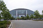
- 2007: Stadium MK opens, and Milton Keynes Dons move in. The Hub & Vizion developments are completed in CMK.
- 2008: University Centre Milton Keynes opens.
2010s
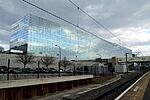
- 2010: The former National Hockey Stadium is demolished. Construction begins on the Network Rail National Centre, Quadrant:MK. The Milton Keynes Shopping Centre is given Grade II listed status (meaning it's a building of special interest). The IF: Milton Keynes International Festival is launched.
- 2011: The population of the Borough of Milton Keynes is 248,821.
- 2012: The Network Rail National Centre (Quadrant:MK) officially opens.
- 2015: Three matches of the 2015 Rugby World Cup are played at Stadium MK.
- 2017: A series of events celebrate 50 years since Milton Keynes was designated.
- 2018: Milton Keynes becomes the first 'city' in the UK planned to have widespread fibre to the home internet. The world's first urban delivery service by robot begins here.
- 2019: The gallery is expanded and includes an art-house cinema. A prize-winning design for MK:U (a planned university of technology) is announced. Milton Keynes is named the European City of Sport for 2020.
2020s
- 2020: The A421 road is upgraded. Work begins on East West Rail (Oxford – Cambridge). Campbell Park is given Grade II listed status.
- 2021: The population of the Borough of Milton Keynes is 287,000.
- 2022: Hotel la Tour opens in Central Milton Keynes. It's the tallest building in the city at 50 meters. The Borough of Milton Keynes is formally awarded city status on August 15, 2022, becoming the City of Milton Keynes.
 | George Robert Carruthers |
 | Patricia Bath |
 | Jan Ernst Matzeliger |
 | Alexander Miles |


