
Bon Secour, Alabama facts for kids
Quick facts for kids
Bon Secour, Alabama
|
|
|---|---|

Looking west over Bon Secour Bay
|
|

Location of Bon Secour in Baldwin County, Alabama.
|
|

Bon Secour, Alabama
Location in Alabama

Bon Secour, Alabama
Location in the United States
|
|
| Country | United States |
| State | Alabama |
| County | Baldwin |
| Area | |
| • Total | 4.65 sq mi (12.05 km2) |
| • Land | 4.32 sq mi (11.19 km2) |
| • Water | 0.33 sq mi (0.86 km2) |
| Population
(2020)
|
|
| • Total | 1,754 |
| • Density | 405.92/sq mi (156.74/km2) |
| Time zone | UTC-6 (Central (CST)) |
| • Summer (DST) | UTC-5 (CDT) |
| ZIP codes |
36511
|
| FIPS code | 01-08272 |
Bon Secour (pronounced "bon sah-KYOOR") is a small community in Baldwin County, Alabama, United States. It's not an official city, but a "census-designated place." This means it's a special area the government counts for population.
Bon Secour is located on the eastern side of Bon Secour Bay. This bay is connected to the bigger Mobile Bay. The community is about 35 miles (56 km) east of the Alabama-Mississippi border. It is also near Gulf Shores, Alabama and about 45 miles (72 km) west of Pensacola, Florida.
The name "Bon Secour" comes from a French phrase. It means "safe harbor." This name fits well because of its quiet location. It sits on the inner coast of the Fort Morgan peninsula.
The community is built along the Bon Secour River. This river is only about 10 feet (3 meters) above sea level. It flows into Bon Secour Bay, which then connects to Mobile Bay. Bon Secour is part of the larger Daphne-Fairhope-Foley metropolitan area.
This area is often mentioned during hurricane reports. This is because it's the easternmost town inside Mobile Bay. It helps show how weather and tides affect the people living there.
Contents
Exploring Bon Secour's History
Bon Secour has a long and interesting past. It started as a French fishing village in the late 1800s. Today, it's a waterfront community. It still provides a safe place for commercial fishing boats.
The area was named by Jacques Cook. He was a French Canadian from Montreal. He came with Pierre Le Moyne d'Iberville's group in 1699. This group helped start Mobile in 1702.
Seafood Industry in Bon Secour
Several big seafood businesses operate here today. These include Bon Secour Fisheries, Safe Harbor Seafood, Aquilla Seafood, and Billy's Seafood. They ship large amounts of seafood from the Gulf of Mexico across the United States.
Bon Secour Fisheries is the oldest and largest. It has been running since the 1890s. The local fishing boats mainly catch shrimp. This includes shrimp from Mobile Bay and "Royal Red" shrimp from deep waters. Large shrimp boats can be seen along the Bon Secour River. They dock at processing plants to package and ship their catch.
The community is proud of its "Alabama Wild Shrimp Program." Local shrimpers work together to promote wild-caught shrimp. This helps them compete with farmed shrimp from other countries. Studies show that wild-caught shrimp from local waters are often cleaner. Even so, the commercial shrimping industry in Bon Secour faces challenges.
Nature and Scenery
Bon Secour is known for its beautiful coastal scenery. You can see huge water oak trees covered in Spanish moss. Great blue herons and brown pelicans are common. You might also spot pods of bottle-nosed dolphins. The air often smells of salty Gulf waters.
The local fishermen are friendly. Besides the small, family-owned seafood plants, Bon Secour has many rural neighborhoods. Most of these homes have lovely views of the Bon Secour River and Bon Secour Bay.
You can see brown pelicans everywhere. Locals sometimes see alligators in the river system. Baby bottle-nosed dolphins often play near the river's mouth. In Bon Secour, you can catch different types of fish. You can find bass, bream, and freshwater catfish. A few miles downriver, in the bay, you can catch saltwater fish, shrimp, and oysters.
Some homes in Bon Secour are among the oldest on the eastern Alabama Gulf Coast. After Hurricane Ivan, new homes were built. Property prices now range from around $100,000 for older homes to millions for new mansions. These new homes are often on the riverbanks or Bon Secour Bay.
New, fancy gated communities are also growing. People with money can buy beautiful land with amazing views. This land offers access to Mobile Bay and the Intracoastal Waterway. This means you can travel by boat to many places. You could go from Bon Secour to Ft. Lauderdale, Florida by water. Boaters can even travel across the Gulf of Mexico to places like Cozumel in Mexico.
Many seabirds, tree frogs, and other animals live in Bon Secour's natural environment.
How Hurricanes Affect Bon Secour
Bon Secour is on the northern coast of the Gulf of Mexico. This location makes it very open to hurricanes.
- In September 1979, Hurricane Frederic hit Bon Secour hard. It was a Category 3 hurricane. It destroyed most of the beachfront in town.
- In September 2004, Hurricane Ivan (Category 3) made landfall nearby. It caused a lot of wind and flood damage. Over 800 homes, mostly condos, were destroyed by Ivan.
- Hurricane Katrina (August 29, 2005) brought a huge storm surge to Bon Secour. The water rose high, even 120 miles (193 km) east of the storm's center. Waves in Mobile Bay near Bon Secour were 22 feet (6.7 m) high.
2010 Gulf Oil Spill
The 2010 Deepwater Horizon oil spill greatly reduced the amount of shrimp available. This caused many people in the fishing industry to lose their jobs. In June 2010, oil blobs and submerged oil washed ashore. This happened on the beaches of the Bon Secour National Wildlife Refuge. It killed many fish and crabs.
Nearby Communities
- Daphne, Alabama
- Elberta, Alabama
- Fairhope, Alabama
- Foley, Alabama
- Gulf Shores, Alabama
- Orange Beach, Alabama
- Point Clear, Alabama
- Robertsdale, Alabama
- Silverhill, Alabama
- Summerdale, Alabama
Geography of Bon Secour
Bon Secour is located at 30°27'56" North, 87°45'13" West. The community covers about 3.4 square miles (8.7 km2) of land. It is right along the Bon Secour River and bay.
Population Information
| Historical population | |||
|---|---|---|---|
| Census | Pop. | %± | |
| 2020 | 1,754 | — | |
| U.S. Decennial Census 1850 1860 1870 1880 1890-1900 1910 1920 1930 1940 1950 1960 1970 1980 1990 2000 2010 2020 |
|||
Bon Secour was first counted as a census-designated place in the 2020 U.S. Census.
Who Lives in Bon Secour?
| Race / Ethnicity (NH = Non-Hispanic) | Pop 2020 | % 2020 |
|---|---|---|
| White alone (NH) | 1,428 | 81.41% |
| Black or African American alone (NH) | 63 | 3.49% |
| Native American or Alaska Native alone (NH) | 11 | 0.63% |
| Asian alone (NH) | 6 | 0.34% |
| Pacific Islander alone (NH) | 1 | 0.06% |
| Some Other Race alone (NH) | 8 | 0.46% |
| Mixed Race or Multi-Racial (NH) | 59 | 3.36% |
| Hispanic or Latino (any race) | 178 | 10.15% |
| Total | 1,754 | 100.00% |
Education in Bon Secour
Students in Bon Secour attend schools in the Baldwin County Public Schools system. These schools are mostly located in the nearby town of Foley.
- Foley High School (grades 9-12)
- Foley Intermediate School (grades 5-6)
- Foley Middle School (grades 7-8)
- Foley Elementary School (grades K-4)
- Swift Elementary School (grades PreK-6) - This school is actually located in Bon Secour.
Climate and Weather
Bon Secour has mild weather all year. In winter, high temperatures average around 65 degrees Fahrenheit (18 degrees Celsius). In summer, high temperatures average around 87 degrees Fahrenheit (31 degrees Celsius). Bon Secour also gets about 61 inches (155 cm) of rain each year.
Bon Secour National Wildlife Refuge
The Bon Secour National Wildlife Refuge (NWR) is a special natural area. It's not directly in Bon Secour, but it's very close by. It's located along Ft. Morgan Road, on the island. You cross the Intracoastal Waterway bridge to get there.
The refuge covers over 6,700 acres (27 km2) of wildlife habitat. It is west of Gulf Shores, Alabama. It's on the Fort Morgan peninsula. This land is formed by the Intracoastal Waterway, Oyster Bay, Bon Secour Bay, and Mobile Bay.
The refuge was created in 1980 by the United States Congress. Its main purpose is to provide a home for birds. These birds migrate south in the fall and north in the spring. Their migration paths go to lower Florida, the Caribbean, Mexico, and Central America.
The Bon Secour refuge is one of the largest undeveloped areas on the Alabama coast. It has sand dunes that remind people of how the Gulf Coast used to look. Because of its natural beauty, the Bon Secour National Wildlife Refuge is considered one of Alabama's ten natural wonders. It has become a very popular place for birdwatching.
Images for kids
-
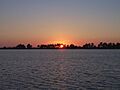
Looking west over Bon Secour Bay
-
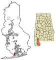
Location of Bon Secour in Baldwin County, Alabama.
See also
 In Spanish: Bon Secour para niños
