Boreen Point, Queensland facts for kids
Quick facts for kids Boreen PointQueensland |
|||||||||||||||
|---|---|---|---|---|---|---|---|---|---|---|---|---|---|---|---|

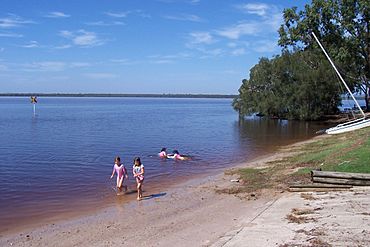
Main Beach, Boreen Point (Note dark Tannin discolouration of the water)
|
|||||||||||||||
| Population | 359 (2021 census) | ||||||||||||||
| • Density | 67.7/km2 (175/sq mi) | ||||||||||||||
| Postcode(s) | 4565 | ||||||||||||||
| Area | 5.3 km2 (2.0 sq mi) | ||||||||||||||
| Time zone | AEST (UTC+10:00) | ||||||||||||||
| Location | |||||||||||||||
| LGA(s) | Shire of Noosa | ||||||||||||||
| State electorate(s) | Noosa | ||||||||||||||
| Federal Division(s) | Wide Bay> | ||||||||||||||
|
|||||||||||||||
Boreen Point is a small, quiet place in Queensland, Australia. It's part of the Shire of Noosa area. Even though there's a town called Boreen nearby, people usually just say Boreen Point. In 2021, about 359 people lived here.
Contents
Exploring Boreen Point's Location
Boreen Point is located north of Tewantin, on Queensland's beautiful Sunshine Coast.
Discover Lake Cootharaba
One of the best things about Boreen Point is Lake Cootharaba. This is a very big, but shallow, lake. It's famous across Australia for being a fantastic spot for sailing and windsurfing. The lake connects to the Noosa River and also leads to amazing national parks.
A Look at Boreen Point's Past
The name "Boreen" comes from an Aboriginal word. It was used by tribes around Moreton Bay and means a path that connected two bora rings. Bora rings were special places where Aboriginal ceremonies took place.
The Historic Apollonian Hotel
In 1987, a very old hotel called the Apollonian Hotel was moved to Boreen Point. It was originally built in the 1860s in Gympie, Queensland. The hotel was named after Apollo, a god from ancient Greek stories.
Changes in Local Government
Boreen Point has always been part of the Shire of Noosa. However, for a few years, from 2008 to 2013, it was part of the Sunshine Coast Region. This change happened when many local areas were combined. But after people in the Noosa area voted, the Shire of Noosa became its own area again.
Who Lives in Boreen Point?
The number of people living in Boreen Point has slowly grown over the years.
- In 2011, there were 264 people.
- By 2016, the population grew to 328 people.
- In 2021, the population was 359 people.
Learning and Schools
There are no schools right in Boreen Point.
- For primary school, kids usually go to Kin Kin State School in Kin Kin (to the west) or Tewantin State School in Tewantin (to the south).
- For high school, the closest option is Noosa District State High School. It has a junior campus in Pomona and a senior campus in Cooroy. Both are to the south-west.
Community Services and Fun Spots
The Shire of Noosa offers a mobile library service that visits Orchard Avenue every week. This means you can borrow books and other items even without a local library building.
Boat Ramps and Water Access
There is a boat ramp on Orchard Avenue that lets you get your boat into Lake Cootharaba and the Noosa River. It's managed by the Noosa Shire Council.
Parks to Explore
Boreen Point has several parks where you can relax and enjoy nature:
- Boreen Point Foreshore Park
- Borg Park
- Coates Park
- Rainforest Court Bushland Reserve
- Urunga Parade Foreshore
Important Facilities
Boreen Point also has important facilities for the community:
- Boreen Point Rural Fire Station (for local fire emergencies)
- Boreen Point SES Facility (for help during storms or other emergencies)
 | Kyle Baker |
 | Joseph Yoakum |
 | Laura Wheeler Waring |
 | Henry Ossawa Tanner |


